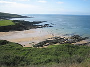
Bovisand
Encyclopedia

Plymouth Sound
Plymouth Sound, or locally just The Sound, is a bay at Plymouth in England.Its southwest and southeast corners are Penlee Point in Cornwall and Wembury Point on Devon, a distance of about 3 nautical miles . Its northern limit is Plymouth Hoe giving a north-south distance of nearly 3 nautical miles...
in Devon
Devon
Devon is a large county in southwestern England. The county is sometimes referred to as Devonshire, although the term is rarely used inside the county itself as the county has never been officially "shired", it often indicates a traditional or historical context.The county shares borders with...
, England
England
England is a country that is part of the United Kingdom. It shares land borders with Scotland to the north and Wales to the west; the Irish Sea is to the north west, the Celtic Sea to the south west, with the North Sea to the east and the English Channel to the south separating it from continental...
.
Despite the steep cliff paths and rocky surrounding, Bovisand features two beaches, a holiday park, privately owned bungalows and a diving centre at Fort Bovisand
Fort Bovisand
thumb|right|Fort Bovisand from the southFort Bovisand is a fort in Devon, England near the beach of Bovisand. It was built on the mainland to defend the entrance of Plymouth Sound, at the narrows opposite the east end of Plymouth Breakwater...
. The area is used by locals more than tourists because of its locality to Plymouth
Plymouth
Plymouth is a city and unitary authority area on the coast of Devon, England, about south-west of London. It is built between the mouths of the rivers Plym to the east and Tamar to the west, where they join Plymouth Sound...
and Wembury
Wembury
Wembury is a village on the south coast of Devon, very close to Plymouth Sound. Wembury is also the name of the peninsula in which the village is situated. The village lies in the administrative district of the South Hams within the South Devon Area of Outstanding Natural Beauty . The South West...
, and because of the larger beaches on the otherside of Plymouth Sound in Cornwall
Cornwall
Cornwall is a unitary authority and ceremonial county of England, within the United Kingdom. It is bordered to the north and west by the Celtic Sea, to the south by the English Channel, and to the east by the county of Devon, over the River Tamar. Cornwall has a population of , and covers an area of...
. It is often referred to as simply Bovi by locals. It lies just outside the boundaries of the city of Plymouth and instead within the district of South Hams
South Hams
South Hams is a local government district on the south coast of Devon, England with its headquarters in the town of Totnes. It contains the towns of Dartmouth, Kingsbridge, Ivybridge, Salcombe — the largest of which is Ivybridge with a population of 16,056....
.
Looking out from Bovisands you can see Plymouth Breakwater
Plymouth Breakwater
Plymouth Breakwater is a stone breakwater protecting Plymouth Sound and the anchorages therein. It is wide at the top and the base is . It lies in about of water. Around 4 million tons of rock were used in its construction in 1812 at the then-colossal cost of £1.5 million .-History:In 1806, as...
, Mount Edgecombe and out across the English Channel
English Channel
The English Channel , often referred to simply as the Channel, is an arm of the Atlantic Ocean that separates southern England from northern France, and joins the North Sea to the Atlantic. It is about long and varies in width from at its widest to in the Strait of Dover...
towards France
France
The French Republic , The French Republic , The French Republic , (commonly known as France , is a unitary semi-presidential republic in Western Europe with several overseas territories and islands located on other continents and in the Indian, Pacific, and Atlantic oceans. Metropolitan France...
.
Bovisand is also known for its tombstoning spots. There are many small jumps, the most popular called 'grassy' by local tombstoners. Another jump that is rarely used is called 'pillbox', because it is a pillbox originating from WW2. This is the tallest of 'proper' jumps at Bovisands, although there is a jump located near grassy. It doesn't have a name, and is 43 ft (14m) tall.

