Bowness-on-Solway
Encyclopedia

House
A house is a building or structure that has the ability to be occupied for dwelling by human beings or other creatures. The term house includes many kinds of different dwellings ranging from rudimentary huts of nomadic tribes to free standing individual structures...
s on the Solway Firth
Solway Firth
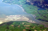
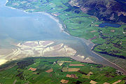
The Solway Firth is a firth that forms part of the border between England and Scotland, between Cumbria and Dumfries and Galloway. It stretches from St Bees Head, just south of Whitehaven in Cumbria, to the Mull of Galloway, on the western end of Dumfries and Galloway. The Isle of Man is also very...
separating England
England
England is a country that is part of the United Kingdom. It shares land borders with Scotland to the north and Wales to the west; the Irish Sea is to the north west, the Celtic Sea to the south west, with the North Sea to the east and the English Channel to the south separating it from continental...
and Scotland
Scotland
Scotland is a country that is part of the United Kingdom. Occupying the northern third of the island of Great Britain, it shares a border with England to the south and is bounded by the North Sea to the east, the Atlantic Ocean to the north and west, and the North Channel and Irish Sea to the...
. It falls in North-West Cumbria
Cumbria
Cumbria , is a non-metropolitan county in North West England. The county and Cumbria County Council, its local authority, came into existence in 1974 after the passage of the Local Government Act 1972. Cumbria's largest settlement and county town is Carlisle. It consists of six districts, and in...
to the west of Carlisle on the English
England
England is a country that is part of the United Kingdom. It shares land borders with Scotland to the north and Wales to the west; the Irish Sea is to the north west, the Celtic Sea to the south west, with the North Sea to the east and the English Channel to the south separating it from continental...
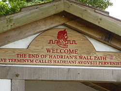
side. The western end of Hadrian's Wall
Hadrian's Wall
Hadrian's Wall was a defensive fortification in Roman Britain. Begun in AD 122, during the rule of emperor Hadrian, it was the first of two fortifications built across Great Britain, the second being the Antonine Wall, lesser known of the two because its physical remains are less evident today.The...
is a major tourist attraction, along with beaches and wading
Wader
Waders, called shorebirds in North America , are members of the order Charadriiformes, excluding the more marine web-footed seabird groups. The latter are the skuas , gulls , terns , skimmers , and auks...
birds. The town is part of the Solway Coast Area of Outstanding Natural Beauty
Area of Outstanding Natural Beauty
An Area of Outstanding Natural Beauty is an area of countryside considered to have significant landscape value in England, Wales or Northern Ireland, that has been specially designated by the Countryside Agency on behalf of the United Kingdom government; the Countryside Council for Wales on...
.
Roman era

Castra
The Latin word castra, with its singular castrum, was used by the ancient Romans to mean buildings or plots of land reserved to or constructed for use as a military defensive position. The word appears in both Oscan and Umbrian as well as in Latin. It may have descended from Indo-European to Italic...
called Maia
Mais (Bowness)
Mais, or Maia, in Cumbria, England was a Roman fort on Hadrian's Wall, and was the last fort at the western end of the Wall....
, at the western end of Hadrian's Wall
Hadrian's Wall
Hadrian's Wall was a defensive fortification in Roman Britain. Begun in AD 122, during the rule of emperor Hadrian, it was the first of two fortifications built across Great Britain, the second being the Antonine Wall, lesser known of the two because its physical remains are less evident today.The...
. It was the second largest fort on the entire Wall. There was also a small civilian settlement (vicus) outside the south gate of the fort.
St Michael's Church
Built atop what may be the granaryWheat
Wheat is a cereal grain, originally from the Levant region of the Near East, but now cultivated worldwide. In 2007 world production of wheat was 607 million tons, making it the third most-produced cereal after maize and rice...
for the Roman fort in the 12th century, the two original bell
Church bell
A church bell is a bell which is rung in a church either to signify the hour or the time for worshippers to go to church, perhaps to attend a wedding, funeral, or other service...
s were stolen by border raiders in 1626, accidentally dropping them in the Solway during their flight. In retaliation, the villagers raided Dornock and Middlebie, making off with a new pair of bells. Traditionally, on inception, the vicar
Vicar
In the broadest sense, a vicar is a representative, deputy or substitute; anyone acting "in the person of" or agent for a superior . In this sense, the title is comparable to lieutenant...
of Annan petitions the village's neighbours for the return of his bells.
Solway Junction Railway
In 1869, the Solway Junction RailwaySolway Junction Railway
The Solway Junction Railway ran between the Caledonian Railway near Kirtlebridge and the Brayton station of the Maryport and Carlisle Railway. The Act of Parliament was granted on 30 June 1864 and the line was opened in 1869. It involved a iron girder viaduct between Bowness-on-Solway and Annan...
was opened between Bowness-on-Solway and Annan
Annan, Dumfries and Galloway
The royal burgh of Annan is a well-built town, red sandstone being the material mainly used. Each year in July, Annan celebrates the Royal Charter and the boundaries of the Royal Burgh are confirmed when a mounted cavalcade undertakes the Riding of the Marches. Entertainment includes a...
in Scotland, connecting to the Maryport & Carlisle railway.
The construction of the railway necessitated a one mile (1.6 km), 176 yards (160.9 m) iron girder
Girder
A girder is a support beam used in construction. Girders often have an I-beam cross section for strength, but may also have a box shape, Z shape or other forms. Girder is the term used to denote the main horizontal support of a structure which supports smaller beams...
viaduct
Viaduct
A viaduct is a bridge composed of several small spans. The term viaduct is derived from the Latin via for road and ducere to lead something. However, the Ancient Romans did not use that term per se; it is a modern derivation from an analogy with aqueduct. Like the Roman aqueducts, many early...
across the Solway, the remains of which can still be seen today. However, numerous problems attended the viaduct
Viaduct
A viaduct is a bridge composed of several small spans. The term viaduct is derived from the Latin via for road and ducere to lead something. However, the Ancient Romans did not use that term per se; it is a modern derivation from an analogy with aqueduct. Like the Roman aqueducts, many early...
. In 1875 and 1881 it was damaged by ice, and by altering sediment-carrying currents it caused nearby Port Carlisle
Port Carlisle
Port Carlisle is a fishing village at Carlisle, Cumbria, England, one mile from Bowness-on-Solway—.Historically within Cumberland, its original name was Fishers Cross, and the port was built in 1819. Four years later, a canal link was added to take goods to Carlisle Basin. The canal was...
to silt
Sediment
Sediment is naturally occurring material that is broken down by processes of weathering and erosion, and is subsequently transported by the action of fluids such as wind, water, or ice, and/or by the force of gravity acting on the particle itself....
up and lose trade. In turn this resulted in the abandonment of the Port Carlisle to Carlisle railway.
In 1914 the railway was restricted to carrying freight only. In 1921 it was closed entirely, and in 1934 the viaduct
Viaduct
A viaduct is a bridge composed of several small spans. The term viaduct is derived from the Latin via for road and ducere to lead something. However, the Ancient Romans did not use that term per se; it is a modern derivation from an analogy with aqueduct. Like the Roman aqueducts, many early...
was demolished.

