
Box Hill, Surrey
Encyclopedia
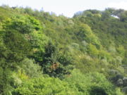
Box Hill is a summit of the North Downs
in Surrey
, approximately 30 km (18.6 mi) south west of London. The hill takes its name from the ancient box woodland found on the steepest west-facing chalk slopes overlooking the River Mole. The western part of the hill is owned and managed by the National Trust
, whilst the village of Box Hill lies on higher ground to the east. The highest point is Betchworth Clumps at 224 m (734.9 ft) above OD
, although the Salomons Memorial overlooking the town of Dorking is the most popular viewpoint.
Box Hill lies within the Surrey Hills Area of Outstanding Natural Beauty
and forms part of the Mole Gap to Reigate Escarpment
Site of Special Scientific Interest. The north- and south-facing slopes support an area of chalk downland, noted for its orchids and other rare plant species. The hill provides a habitat for 40 species of butterfly, and has given its name to a species of squash bug
, now found throughout south east England.
An estimated 850,000 people visit Box Hill each year. The National Trust visitors' centre provides both a cafeteria and gift shop and the panoramic views of the western Weald may be enjoyed from the North Downs Way
, a long distance footpath that runs along the southern escarpment. Box Hill will feature prominently on the route of the 2012 Summer Olympics cycling
road race events, the men doing nine circuits and the women doing two circuits.
is located in the village of Mickleham
about 1.4 kilometre (0.869921831309729 mi) to the north and the hill overlooks the town of Dorking
to the south west. The hill is approximately 30 km (18.6 mi) south west of central London.
The National Trust owns and manages much of the western part of Box Hill. Leopold Salomons
, owner of Norbury Park
donated 95 ha (234.7 acre) in 1914 in order to protect it from development. Additional land was purchased or donated between 1921 and 1999 and today the Box Hill estate covers an area of around 490 ha (1,210.8 acre), including Mickleham Downs to the north and Lower Boxhill Farm to the south.
The village of Box Hill is located to the east of the National Trust property. The earliest flint cottages date from the 1800s, although much of the village was constructed in the first half of the 20th century. By 2005 there were more than 800 dwellings of which over five hundred were mobile homes. An estimated 41% of the community is aged 60 or over. St Andrew's Church, part of the Parish of Headley, was opened in 1969 and the village hall opened in 1972.
and included in a designated Site of Special Scientific Interest
, affording it a level of legislative protection against planning applications. The chalk downland environment supports notable populations of bat
s, lepidopterans, orchids and the hill's namesake
, the box tree (buxus sempervirens
).
 Box Hill was given to the nation by Leopold Salomons
in 1914.
A country park
, owned by the National Trust
, now provides for public access to Box Hill, and the Pilgrims' Way
long distance footpath runs about 1 kilometre (0.621372736649807 mi) to the south.
At the "top" of the hill there is a car park
and viewpoint, from where the entire town of Dorking can be viewed. However, this location is not actually the true summit of the hill. To the east, the ridge ascends, and most of the village of Box Hill is higher, at an altitude of around 200 metres (656 ft). The Ordnance Survey mark a spot height of 224 metres (735 ft) at the radio mast at .
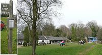
Within the area of the car park there is a National Trust
Shop, a small 'visitor centre' (inside the shop) and a café (take-away only). The car park is owned and run by the National Trust. Details of trails are available in this area. There are several potential trails, although they aren't necessarily clearly marked (e.g. the 'Family Fun Trail', details of which are available in the shop).
Box Hill is served by local and London
bus routes, providing access to both the visitor centre and the foot of the hill, where there exists another car park (adjoining Ryka's Café) that is frequented by motorcyclists
.
The route to the top car park from the A24, known as the Zig Zag Road, is very narrow and is a popular test of fitness by road cyclists. There is another small car park half way up this, with room for only around 10 cars.
The nearest railway station is Box Hill & Westhumble railway station.
, i.e. Chanctonbury Ring
and Devil's Dyke, Sussex
(a distance of 26 miles, according to the inscription on the viewing platform).
The Salomons Memorial is often mistakenly considered the summit of the hill, although the land continues to rise to the east. The highest point is at Betchworth Clumps, a wooded area to the south of the Hand-in-Hand public house, with an elevation of 224 metres (735 ft). The summit is occupied by a water tower and transmitter mast.
) built to protect London from invasion from continental Europe. The building cannot be entered by visitors. It is inhabited by bats.
, who purchased Juniper Hall
in 1815.
descent. He joined the British Army at the age of 14, becoming a Major in 1760. After leaving the army he became a political agitator and was accused in 1775 of bribing British Troops not to fight in the American War of Independence, although he was never tried for treason. Throughout the 1770-80s Labiliere corresponded regularly with both Benjamin Franklin
(at that time the American representative in France) and the Long Island wax sculptor Patience Wright
. The effect of his anti-war protests on British public sentiment is uncertain, although he appears to have attracted a following of upwards of 700 like-minded adherents, and the army was required to rely on German mercenaries, as recruitment of British troops for the war became increasingly difficult.
Labilliere moved to Dorking from London in around 1789, and often visited Box Hill to meditate. With old age he became increasingly eccentric and neglected his own personal hygiene to such an extent that he acquired the nickname "the walking dung-hill". In accordance with his wishes he was buried head downwards in June 1800 on the western side of Box Hill above The Whites. The burial was carried out without any religious ceremony and Labilliere is reported to have said that the world was "topsy-turvey" and that it would be righted in the end. He may also have wished to emulate the example of St Peter
, who was crucified upside-down
according to apocryphal sources.
The memorial stone on Box Hill is not believed to mark the exact location of his burial (which is though to be several meters to the west on a steep incline). There are two errors on the memorial stone itself: He was buried in June 1800 (rather than July) and all surviving manuscripts indicate that he spelt his name Labilliere (rather than Labelliere).
 The Weypole (or Waypole) is a roughly semi-circular 2.4 ha (5.9 acre) area of level ground at the foot of Box Hill, between The Whites and the River Mole. The area was originally part of the grounds of Burford Lodge, built by John Eckersall in 1776, and the prevalence of apple and cherry trees in the area suggest that it was used as an orchard for a time. The Burford Lodge estate was later owned by the horticuluralist Sir Trevor Lawrence, who created a garden along the banks of the Mole for his collection of orchids.
A fording point across the River Mole is thought to have existed at this site since prehistoric times.(ref) The way-pole itself was a notched post secured in the riverbed, to indicate the depth of the water. Stepping stones at this site are first recorded in 1841 and it is possible that they were installed by an owner of Burford Lodge to facilitate access to the Weypole orchard. The current stones were dedicated in September 1946 by the then Prime Minister Clement Attlee
, replacing those destroyed during WW2 as an anti-invasion measure. The location is popular both with anglers and families, although swimming is strongly discouraged. The stones give their name to the pub in the nearby village of Westhumble
.
 John Logie Baird
, the inventor of the first working television system lived at Swiss Cottage from 1929 until 1932. Baird conducted some of his experiments on Box Hill, including his Noctovisor, an infra-red viewing device.
North Downs
The North Downs are a ridge of chalk hills in south east England that stretch from Farnham in Surrey to the White Cliffs of Dover in Kent. The North Downs lie within two Areas of Outstanding Natural Beauty , the Surrey Hills and the Kent Downs...
in Surrey
Surrey
Surrey is a county in the South East of England and is one of the Home Counties. The county borders Greater London, Kent, East Sussex, West Sussex, Hampshire and Berkshire. The historic county town is Guildford. Surrey County Council sits at Kingston upon Thames, although this has been part of...
, approximately 30 km (18.6 mi) south west of London. The hill takes its name from the ancient box woodland found on the steepest west-facing chalk slopes overlooking the River Mole. The western part of the hill is owned and managed by the National Trust
National Trust for Places of Historic Interest or Natural Beauty
The National Trust for Places of Historic Interest or Natural Beauty, usually known as the National Trust, is a conservation organisation in England, Wales and Northern Ireland...
, whilst the village of Box Hill lies on higher ground to the east. The highest point is Betchworth Clumps at 224 m (734.9 ft) above OD
Ordnance Datum
In the British Isles, an Ordnance Datum or OD is a vertical datum used by an ordnance survey as the basis for deriving altitudes on maps. A spot height may be expressed as AOD for "above ordnance datum". Usually mean sea level is used for the datum...
, although the Salomons Memorial overlooking the town of Dorking is the most popular viewpoint.
Box Hill lies within the Surrey Hills Area of Outstanding Natural Beauty
Surrey Hills AONB
The Surrey Hills is a Area of Outstanding Natural Beauty , located in Surrey, England. The AONB was designated in 1958 and covers one quarter of the county of Surrey...
and forms part of the Mole Gap to Reigate Escarpment
Mole Gap to Reigate Escarpment
Mole Gap to Reigate Escarpment is a Site of Special Scientific Interest in Surrey, England. It is owned and managed by the National Trust.The site includes part of the North Downs which has remained relatively undisturbed by the pressures of modern farming and building. It stretches for 8 miles ...
Site of Special Scientific Interest. The north- and south-facing slopes support an area of chalk downland, noted for its orchids and other rare plant species. The hill provides a habitat for 40 species of butterfly, and has given its name to a species of squash bug
Coreidae
Coreidae are a large family of predominantly herbivorous insects that belong in the hemipteran suborder Heteroptera. There are more than 1,800 species in over 250 genera. They vary in size from 7 to 45 mm, making the larger species some of the biggest heteropterans. The body shape of coreids...
, now found throughout south east England.
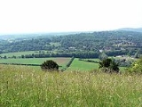
An estimated 850,000 people visit Box Hill each year. The National Trust visitors' centre provides both a cafeteria and gift shop and the panoramic views of the western Weald may be enjoyed from the North Downs Way
North Downs Way
The North Downs Way is a long-distance path in southern England, opened in 1978. It runs from Farnham to Dover, past Godalming, Guildford, Dorking, Merstham, Otford and Rochester, along the Surrey Hills Area of Outstanding Natural Beauty and Kent Downs AONB.East of Boughton Lees, the path splits...
, a long distance footpath that runs along the southern escarpment. Box Hill will feature prominently on the route of the 2012 Summer Olympics cycling
Cycling at the 2012 Summer Olympics
Cycling at the 2012 Summer Olympics is scheduled to take place at five different venues. The venues are the London Velopark for track cycling and BMX, and Hadleigh Farm in Essex for mountain biking...
road race events, the men doing nine circuits and the women doing two circuits.
Geography
Box Hill stands at the south eastern corner of the Mole Gap, the valley carved by the River Mole through the North Downs. Box Hill SchoolBox Hill School
Box Hill School is an independent coeducational boarding and day school situated in the village of Mickleham near Dorking, Surrey, England. The school has approximately 425 pupils aged 11–18, about a quarter of which are from overseas...
is located in the village of Mickleham
Mickleham, Surrey
Mickleham is a village and civil parish between the towns of Dorking and Leatherhead in Surrey, England covering . The parish includes the hamlet of Fredley.-History:Mickleham lies near to the old Roman road known as Stane Street...
about 1.4 kilometre (0.869921831309729 mi) to the north and the hill overlooks the town of Dorking
Dorking
Dorking is a historic market town at the foot of the North Downs approximately south of London, in Surrey, England.- History and development :...
to the south west. The hill is approximately 30 km (18.6 mi) south west of central London.
The National Trust owns and manages much of the western part of Box Hill. Leopold Salomons
Leopold Salomons
Leopold Salomons was a city financier and company director active in the City of London in the late nineteenth and early twentieth centuries. Salomons was born into a British Jewish family, but it has been suggested that he later converted to Christianity...
, owner of Norbury Park
Norbury Park
Norbury Park is a swathe of land arranged around a small manor house near Leatherhead and Dorking, Surrey, which appears in the Domesday Book of 1086. The manor was also known as Northbury for some time....
donated 95 ha (234.7 acre) in 1914 in order to protect it from development. Additional land was purchased or donated between 1921 and 1999 and today the Box Hill estate covers an area of around 490 ha (1,210.8 acre), including Mickleham Downs to the north and Lower Boxhill Farm to the south.
The village of Box Hill is located to the east of the National Trust property. The earliest flint cottages date from the 1800s, although much of the village was constructed in the first half of the 20th century. By 2005 there were more than 800 dwellings of which over five hundred were mobile homes. An estimated 41% of the community is aged 60 or over. St Andrew's Church, part of the Parish of Headley, was opened in 1969 and the village hall opened in 1972.
Environment
Box Hill is a Special Area of ConservationSpecial Area of Conservation
A Special Area of Conservation is defined in the European Union's Habitats Directive , also known as the Directive on the Conservation of Natural Habitats and of Wild Fauna and Flora...
and included in a designated Site of Special Scientific Interest
Mole Gap to Reigate Escarpment
Mole Gap to Reigate Escarpment is a Site of Special Scientific Interest in Surrey, England. It is owned and managed by the National Trust.The site includes part of the North Downs which has remained relatively undisturbed by the pressures of modern farming and building. It stretches for 8 miles ...
, affording it a level of legislative protection against planning applications. The chalk downland environment supports notable populations of bat
Bat
Bats are mammals of the order Chiroptera "hand" and pteron "wing") whose forelimbs form webbed wings, making them the only mammals naturally capable of true and sustained flight. By contrast, other mammals said to fly, such as flying squirrels, gliding possums, and colugos, glide rather than fly,...
s, lepidopterans, orchids and the hill's namesake
Namesake
Namesake is a term used to characterize a person, place, thing, quality, action, state, or idea that has the same, or a similar, name to another....
, the box tree (buxus sempervirens
Buxus sempervirens
Buxus sempervirens is a flowering plant in the genus Buxus, native to western and southern Europe, northwest Africa, and southwest Asia, from southern England south to northern Morocco, and east through the northern Mediterranean region to Turkey. Buxus colchica of western Caucasus and B...
).
Public access
Leopold Salomons
Leopold Salomons was a city financier and company director active in the City of London in the late nineteenth and early twentieth centuries. Salomons was born into a British Jewish family, but it has been suggested that he later converted to Christianity...
in 1914.
A country park
Country park
A country park is an area designated for people to visit and enjoy recreation in a countryside environment.-History:In the United Kingdom the term 'Country Park' has a special meaning. There are over 400 Country Parks in England alone . Most Country Parks were designated in the 1970s, under the...
, owned by the National Trust
National Trust for Places of Historic Interest or Natural Beauty
The National Trust for Places of Historic Interest or Natural Beauty, usually known as the National Trust, is a conservation organisation in England, Wales and Northern Ireland...
, now provides for public access to Box Hill, and the Pilgrims' Way
Pilgrims' Way
The Pilgrims' Way is the historic route supposed to have been taken by pilgrims from Winchester in Hampshire, England, to the shrine of Thomas Becket at Canterbury in Kent...
long distance footpath runs about 1 kilometre (0.621372736649807 mi) to the south.
At the "top" of the hill there is a car park
Parking lot
A parking lot , also known as car lot, is a cleared area that is intended for parking vehicles. Usually, the term refers to a dedicated area that has been provided with a durable or semi-durable surface....
and viewpoint, from where the entire town of Dorking can be viewed. However, this location is not actually the true summit of the hill. To the east, the ridge ascends, and most of the village of Box Hill is higher, at an altitude of around 200 metres (656 ft). The Ordnance Survey mark a spot height of 224 metres (735 ft) at the radio mast at .
Within the area of the car park there is a National Trust
National Trust for Places of Historic Interest or Natural Beauty
The National Trust for Places of Historic Interest or Natural Beauty, usually known as the National Trust, is a conservation organisation in England, Wales and Northern Ireland...
Shop, a small 'visitor centre' (inside the shop) and a café (take-away only). The car park is owned and run by the National Trust. Details of trails are available in this area. There are several potential trails, although they aren't necessarily clearly marked (e.g. the 'Family Fun Trail', details of which are available in the shop).
Box Hill is served by local and London
London Buses route 465
London Buses route 465 is a Transport for London contracted bus route in London, United Kingdom. The service is currently contracted to Metrobus.-History:...
bus routes, providing access to both the visitor centre and the foot of the hill, where there exists another car park (adjoining Ryka's Café) that is frequented by motorcyclists
Motorcycle
A motorcycle is a single-track, two-wheeled motor vehicle. Motorcycles vary considerably depending on the task for which they are designed, such as long distance travel, navigating congested urban traffic, cruising, sport and racing, or off-road conditions.Motorcycles are one of the most...
.
The route to the top car park from the A24, known as the Zig Zag Road, is very narrow and is a popular test of fitness by road cyclists. There is another small car park half way up this, with room for only around 10 cars.
The nearest railway station is Box Hill & Westhumble railway station.
Notable Sights
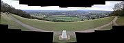
Salomons Memorial (viewpoint)
The most notable sight on Box Hill is the view from the viewing platform. It gives a very clear view, roughly south over Dorking and further in the distance towards Gatwick Airport and right across to the South DownsSouth Downs
The South Downs is a range of chalk hills that extends for about across the south-eastern coastal counties of England from the Itchen Valley of Hampshire in the west to Beachy Head, near Eastbourne, East Sussex, in the east. It is bounded on its northern side by a steep escarpment, from whose...
, i.e. Chanctonbury Ring
Chanctonbury Ring
Chanctonbury Ring is a hill fort based ring of trees atop Chanctonbury Hill on the South Downs, on the border of the civil parishes of Washington and Wiston in the English county of West Sussex. A ridgeway, now part of the South Downs Way, runs along the hill...
and Devil's Dyke, Sussex
Devil's Dyke, Sussex
Devil's Dyke is a V-shaped valley on the South Downs Way in southern England, near Brighton and Hove. It is part of the Southern England Chalk Formation.Devil's Dyke is on the way to Brighton and is a big hill at the side of the road.-Geological history:...
(a distance of 26 miles, according to the inscription on the viewing platform).
The Salomons Memorial is often mistakenly considered the summit of the hill, although the land continues to rise to the east. The highest point is at Betchworth Clumps, a wooded area to the south of the Hand-in-Hand public house, with an elevation of 224 metres (735 ft). The summit is occupied by a water tower and transmitter mast.
The Old Fort
Close to the car park and shop there is the 'Old Fort'. This was built in the late 1890s as one of a number of forts (known as the London Defence PositionsLondon Defence Positions
The London Defence Positions were 19th century earthworks in the south-east of England, designed to protect London from foreign invasion landing on the south coast....
) built to protect London from invasion from continental Europe. The building cannot be entered by visitors. It is inhabited by bats.
Broadwood's Folly
The circular flint tower located on the northern tip of Lodge Hill was built for the piano maker Thomas BroadwoodBroadwood and Sons
Broadwood and Sons is an English piano manufacturer, founded in 1728 by Burkat Shudi and continued after his death in 1773 by John Broadwood.- Early history :...
, who purchased Juniper Hall
Juniper Hall
Juniper Hall Field Centre, leased from the National Trust, is a 18th century country house in a quiet wooded valley within the chalk North Downs in Surrey. It is about from Box Hill and only from central London. Nearby habitats and environments for study include unimproved chalk grassland,...
in 1815.
Labilliere's Grave
Peter Labilliere was born in Dublin on 30th May 1725 to a family of French HuguenotHuguenot
The Huguenots were members of the Protestant Reformed Church of France during the 16th and 17th centuries. Since the 17th century, people who formerly would have been called Huguenots have instead simply been called French Protestants, a title suggested by their German co-religionists, the...
descent. He joined the British Army at the age of 14, becoming a Major in 1760. After leaving the army he became a political agitator and was accused in 1775 of bribing British Troops not to fight in the American War of Independence, although he was never tried for treason. Throughout the 1770-80s Labiliere corresponded regularly with both Benjamin Franklin
Benjamin Franklin
Dr. Benjamin Franklin was one of the Founding Fathers of the United States. A noted polymath, Franklin was a leading author, printer, political theorist, politician, postmaster, scientist, musician, inventor, satirist, civic activist, statesman, and diplomat...
(at that time the American representative in France) and the Long Island wax sculptor Patience Wright
Patience Wright
Patience Lovell Wright was the first recognized American-born sculptor. She chiefly created wax figures of people. She loved to write poetry and was also a painter....
. The effect of his anti-war protests on British public sentiment is uncertain, although he appears to have attracted a following of upwards of 700 like-minded adherents, and the army was required to rely on German mercenaries, as recruitment of British troops for the war became increasingly difficult.
Labilliere moved to Dorking from London in around 1789, and often visited Box Hill to meditate. With old age he became increasingly eccentric and neglected his own personal hygiene to such an extent that he acquired the nickname "the walking dung-hill". In accordance with his wishes he was buried head downwards in June 1800 on the western side of Box Hill above The Whites. The burial was carried out without any religious ceremony and Labilliere is reported to have said that the world was "topsy-turvey" and that it would be righted in the end. He may also have wished to emulate the example of St Peter
Saint Peter
Saint Peter or Simon Peter was an early Christian leader, who is featured prominently in the New Testament Gospels and the Acts of the Apostles. The son of John or of Jonah and from the village of Bethsaida in the province of Galilee, his brother Andrew was also an apostle...
, who was crucified upside-down
Cross of St. Peter
The Cross of St. Peter or Petrine Cross is an inverted Latin cross traditionally used as a Christian symbol, but in recent times also used widely as an anti-Christ symbol .-In Christianity:The origin of this symbol comes from the Catholic tradition that Simon Peter was crucified upside...
according to apocryphal sources.
The memorial stone on Box Hill is not believed to mark the exact location of his burial (which is though to be several meters to the west on a steep incline). There are two errors on the memorial stone itself: He was buried in June 1800 (rather than July) and all surviving manuscripts indicate that he spelt his name Labilliere (rather than Labelliere).
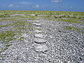
Weypole and Stepping Stones
A fording point across the River Mole is thought to have existed at this site since prehistoric times.(ref) The way-pole itself was a notched post secured in the riverbed, to indicate the depth of the water. Stepping stones at this site are first recorded in 1841 and it is possible that they were installed by an owner of Burford Lodge to facilitate access to the Weypole orchard. The current stones were dedicated in September 1946 by the then Prime Minister Clement Attlee
Clement Attlee
Clement Richard Attlee, 1st Earl Attlee, KG, OM, CH, PC, FRS was a British Labour politician who served as the Prime Minister of the United Kingdom from 1945 to 1951, and as the Leader of the Labour Party from 1935 to 1955...
, replacing those destroyed during WW2 as an anti-invasion measure. The location is popular both with anglers and families, although swimming is strongly discouraged. The stones give their name to the pub in the nearby village of Westhumble
Westhumble
Westhumble is a village situated north of Dorking in Surrey, England. Neighbouring villages include Mickleham and Great Bookham. The census area Mickleham, Westhumble and Pixham has a population of 1,932....
.
Other
John Logie Baird
John Logie Baird FRSE was a Scottish engineer and inventor of the world's first practical, publicly demonstrated television system, and also the world's first fully electronic colour television tube...
, the inventor of the first working television system lived at Swiss Cottage from 1929 until 1932. Baird conducted some of his experiments on Box Hill, including his Noctovisor, an infra-red viewing device.