

Breakpoint (meteorology)
Encyclopedia
Meteorology
Meteorology is the interdisciplinary scientific study of the atmosphere. Studies in the field stretch back millennia, though significant progress in meteorology did not occur until the 18th century. The 19th century saw breakthroughs occur after observing networks developed across several countries...
when issuing watches, warnings, or advisories, for specific areas. Breakpoints are used when coastal and offshore areas need to be warned of an impending weather event, usually pertaining to a hazard faced because of the water.
Breakpoints are typically defined by the name of a place or town on the coast, by a geographic feature, or by some combination of latitude and longitude. Breakpoints are used by various meteorological organizations worldwide, including the National Hurricane Center
National Hurricane Center
The National Hurricane Center , located at Florida International University in Miami, Florida, is the division of the National Weather Service responsible for tracking and predicting weather systems within the tropics between the Prime Meridian and the 140th meridian west poleward to the 30th...
(NHC), the Japan Meteorological Agency
Japan Meteorological Agency
The or JMA, is the Japanese government's weather service. Charged with gathering and reporting weather data and forecasts in Japan, it is a semi-autonomous part of the Ministry of Land, Infrastructure and Transport...
(JMA), and the National Weather Service
National Weather Service
The National Weather Service , once known as the Weather Bureau, is one of the six scientific agencies that make up the National Oceanic and Atmospheric Administration of the United States government...
(NWS).
Use of breakpoints
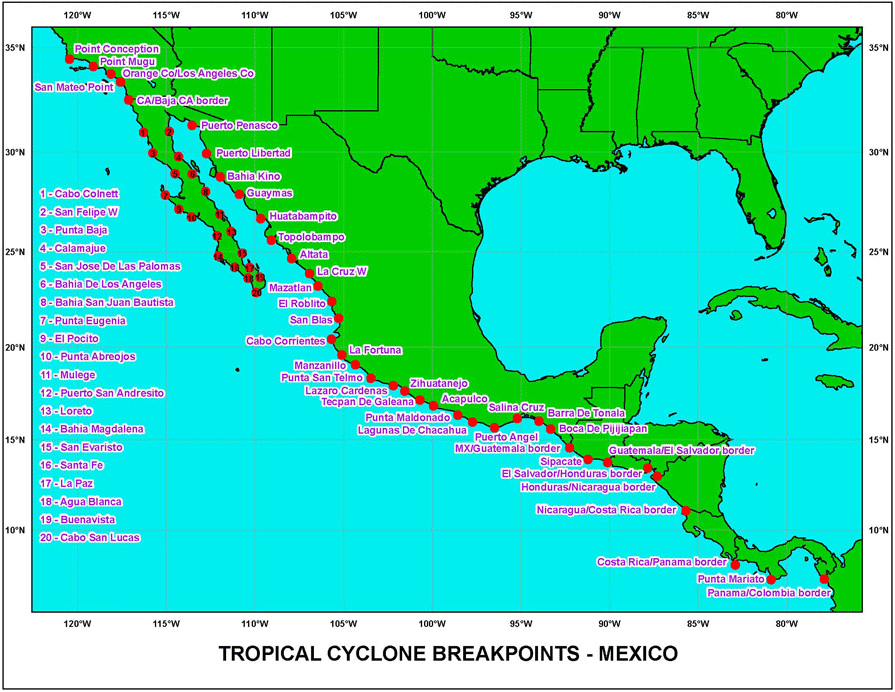
Breakpoints, in general, are used to specify the endpoints of a region to be discussed by a meteorologist. While virtually any point can be used for informal discussions, a list of formal breakpoints is generally used for issuing warnings and forecasts for an area.The National Hurricane Center has a list of both formal and informal breakpoints, which it uses throughout its areas of responsibility in the Eastern Pacific
Pacific hurricane
A Pacific hurricane or tropical storm is a tropical cyclone that develops in the northeastern part of the Pacific Ocean. For organizational purposes, the northern Pacific Ocean is divided into three regions: the eastern, , central , and western...
, and in the Atlantic basin
Atlantic hurricane
North Atlantic tropical cyclones usually form in the northern hemisphere summer or fall. Tropical cyclones can be categorized by intensity. Tropical storms have one-minute maximum sustained winds of at least 39 mph , while hurricanes have one-minute maximum sustained exceeding 74 mph...
. All of these breakpoints are defined as points on the coastline, and are usually significant towns that are a reasonable distance apart, though the exact distance varies. The NHC's list of breakpoints http://www.nhc.noaa.gov/breakpoints_list.shtml? is adhered to for the issuance of hurricane watches and warnings, for sections of coastline, though the forecasts and the informal discussions are not limited to using breakpoints as points of reference.
The NWS is similar to the NHC in its use of breakpoints, in that the breakpoints are used for the issuance of watches and warnings, though beyond that the NWS is stricter in its use of breakpoints. In general, the breakpoints used by the NWS are a combination of latitude or longitude points (such as 35N), and geographical features (such as Hatteras Canyon
Cape Hatteras
Cape Hatteras is a cape on the coast of North Carolina. It is the point that protrudes the farthest to the southeast along the northeast-to-southwest line of the Atlantic coast of North America...
). The NWS breakpoints are also significantly fewer and spread out, resulting in a larger distance between the breakpoints. The NWS issues forecasts for the area between each breakpoint, defining each as a forecast zone. In general, the NWS's breakpoints serve almost solely as endpoints to the zones, as watches, warnings, and forecasts are all issued for each zone between consecutive breakpoints.
The use as breakpoints comes into play when consecutive zones are being discussed, in which the breakpoints at the end of the entire region can be used. The JMA is similar to the NWS in forecasts and most warnings are issued by zone, though tropical cyclone warnings are issued differently. Like the NHC, the JMA issues most of its tropical cyclone
Tropical cyclone
A tropical cyclone is a storm system characterized by a large low-pressure center and numerous thunderstorms that produce strong winds and heavy rain. Tropical cyclones strengthen when water evaporated from the ocean is released as the saturated air rises, resulting in condensation of water vapor...
advisories for a section of coast, usually chosen to coincide with the zone endpoints, creating a system of breakpoints and a warning methodology, similar in appearance to the NHC.
Various other meteorological agencies across the world use breakpoints as well, though to a lesser extent than the three agencies discussed above.