
Briningham
Encyclopedia
Briningham is a village and a civil parish in the English
county
of Norfolk
. The village is 9.9 miles east north east of the town of Fakenham
, 13.3 miles west south west of Cromer
, 22.3 miles north north west of the city of Norwich
, and 124 miles north north east of London
. The nearest railway station is at Sheringham
for the Bittern Line
which runs between Sheringham
, Cromer and Norwich. There is an abandoned railway line which is considered as a footpath, it runs parallel with an old track "the lane" that leads up to "belle vue tower". The nearest airport is Norwich International Airport
. The civil parish had in 2001 census
a population of 122. For the purposes of local government, the parish falls within the district
of North Norfolk
.
of 1085. In the great book Briningham is recorded by the names Bruningaham, and Biringaham. The main landholders were Count Alan
and Bishop William
. The main tenant is said to be Roger Longwood. The survey also mentions that there are five beehives, a church and a mill.
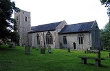
is unusual in that the church tower is on the south side. On the east wall of the interior there are two large statues of Saint Maurice and the Blessed Virgin which are set into niches. In the south wall there is a 14th century window. Within the graveyard stands a ten-foot-high pyramidal memorial to members of the Brereton family, on top of which sits the head of a muzzled bear. It is a Grade I listed building http://www.imagesofengland.org.uk/details/default.aspx?id=223523.
England
England is a country that is part of the United Kingdom. It shares land borders with Scotland to the north and Wales to the west; the Irish Sea is to the north west, the Celtic Sea to the south west, with the North Sea to the east and the English Channel to the south separating it from continental...
county
County
A county is a jurisdiction of local government in certain modern nations. Historically in mainland Europe, the original French term, comté, and its equivalents in other languages denoted a jurisdiction under the sovereignty of a count A county is a jurisdiction of local government in certain...
of Norfolk
Norfolk
Norfolk is a low-lying county in the East of England. It has borders with Lincolnshire to the west, Cambridgeshire to the west and southwest and Suffolk to the south. Its northern and eastern boundaries are the North Sea coast and to the north-west the county is bordered by The Wash. The county...
. The village is 9.9 miles east north east of the town of Fakenham
Fakenham
Fakenham is a town and civil parish in Norfolk, England. It is situated on the River Wensum, some north east of King's Lynn, south west of Cromer, and north west of Norwich....
, 13.3 miles west south west of Cromer
Cromer
Cromer is a coastal town and civil parish in north Norfolk, England. The local government authority is North Norfolk District Council, whose headquarters is in Holt Road in the town. The town is situated 23 miles north of the county town, Norwich, and is 4 miles east of Sheringham...
, 22.3 miles north north west of the city of Norwich
Norwich
Norwich is a city in England. It is the regional administrative centre and county town of Norfolk. During the 11th century, Norwich was the largest city in England after London, and one of the most important places in the kingdom...
, and 124 miles north north east of London
London
London is the capital city of :England and the :United Kingdom, the largest metropolitan area in the United Kingdom, and the largest urban zone in the European Union by most measures. Located on the River Thames, London has been a major settlement for two millennia, its history going back to its...
. The nearest railway station is at Sheringham
Sheringham railway station
Sheringham railway station is a timber halt in the town of Sheringham in the English county of Norfolk. The station is the terminus of the Bittern Line, operated by National Express East Anglia, and is 49 km north of...
for the Bittern Line
Bittern Line
The Bittern Line is a railway line from Norwich to Cromer then Sheringham in Norfolk, England. It is one of the most scenic in the East of England traversing the Norfolk Broads on its route to the Area of Outstanding Natural Beauty on the North Norfolk Coast. The line is part of the Network Rail...
which runs between Sheringham
Sheringham
Sheringham is a seaside town in Norfolk, England, west of Cromer.The motto of the town, granted in 1953 to the Sheringham Urban District Council, is Mare Ditat Pinusque Decorat, Latin for "The sea enriches and the pine adorns"....
, Cromer and Norwich. There is an abandoned railway line which is considered as a footpath, it runs parallel with an old track "the lane" that leads up to "belle vue tower". The nearest airport is Norwich International Airport
Norwich International Airport
Norwich International Airport , also known as Norwich Airport, is an airport in the City of Norwich within Norfolk, England north of the city centre and on the edge of the city's suburbs....
. The civil parish had in 2001 census
United Kingdom Census 2001
A nationwide census, known as Census 2001, was conducted in the United Kingdom on Sunday, 29 April 2001. This was the 20th UK Census and recorded a resident population of 58,789,194....
a population of 122. For the purposes of local government, the parish falls within the district
Non-metropolitan district
Non-metropolitan districts, or colloquially shire districts, are a type of local government district in England. As created, they are sub-divisions of non-metropolitan counties in a so-called "two-tier" arrangement...
of North Norfolk
North Norfolk
North Norfolk is a local government district in Norfolk, United Kingdom. Its council is based in Cromer. The council headquarters can be found approximately out of the town of Cromer on the Holt Road.-History:...
.
History
Briningham has an entry in the Domesday BookDomesday Book
Domesday Book , now held at The National Archives, Kew, Richmond upon Thames in South West London, is the record of the great survey of much of England and parts of Wales completed in 1086...
of 1085. In the great book Briningham is recorded by the names Bruningaham, and Biringaham. The main landholders were Count Alan
Alan IV, Duke of Brittany
Alan IV was Duke of Brittany, from 1084 until his abdication in 1112. He was also Count of Nantes and Count of Rennes. He was son of Hawise, Duchess of Brittany and Duke Hoel II. He was known as Alan Fergant, which in Breton means "Alan the Strong"...
and Bishop William
William de Beaufeu
William de Beaufeu was a medieval Bishop of Thetford and a major landholder mentioned in the Domesday Book.-Life:...
. The main tenant is said to be Roger Longwood. The survey also mentions that there are five beehives, a church and a mill.
Buildings
The main and oldest buildings are "belle vue tower";originally thought to have been a mill but was actually watch tower,rose cottage, the mission hall; the old Methodist chapel and the mill lane houses.Saint Maurice parish church
The parish church of Saint MauriceSaint Maurice
Saint Maurice was the leader of the legendary Roman Theban Legion in the 3rd century, and one of the favorite and most widely venerated saints of that group. He was the patron saint of several professions, locales, and kingdoms...
is unusual in that the church tower is on the south side. On the east wall of the interior there are two large statues of Saint Maurice and the Blessed Virgin which are set into niches. In the south wall there is a 14th century window. Within the graveyard stands a ten-foot-high pyramidal memorial to members of the Brereton family, on top of which sits the head of a muzzled bear. It is a Grade I listed building http://www.imagesofengland.org.uk/details/default.aspx?id=223523.