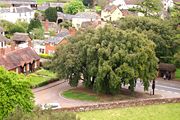
Broadclyst
Encyclopedia

Civil parish
In England, a civil parish is a territorial designation and, where they are found, the lowest tier of local government below districts and counties...
that lies approximately 5 miles northeast of the city of Exeter
Exeter
Exeter is a historic city in Devon, England. It lies within the ceremonial county of Devon, of which it is the county town as well as the home of Devon County Council. Currently the administrative area has the status of a non-metropolitan district, and is therefore under the administration of the...
, in the district of East Devon
East Devon
East Devon is a local government district in Devon, England. Its council is based in Sidmouth, and the largest town is Exmouth.The district was formed on 1 April 1974 by the merger of the borough of Honiton with the urban districts of Budleigh Salterton, Exmouth, Ottery St. Mary, Seaton, Sidmouth...
, England
England
England is a country that is part of the United Kingdom. It shares land borders with Scotland to the north and Wales to the west; the Irish Sea is to the north west, the Celtic Sea to the south west, with the North Sea to the east and the English Channel to the south separating it from continental...
, on the B3181. In 2001 its population was 2830.
Its church is 15th century, with an ancient cross. It has many battlements, pinnacles and gargoyle
Gargoyle
In architecture, a gargoyle is a carved stone grotesque, usually made of granite, with a spout designed to convey water from a roof and away from the side of a building thereby preventing rainwater from running down masonry walls and eroding the mortar between...
s. In the year 1001 the village is said to have been burned down by Danish
Denmark
Denmark is a Scandinavian country in Northern Europe. The countries of Denmark and Greenland, as well as the Faroe Islands, constitute the Kingdom of Denmark . It is the southernmost of the Nordic countries, southwest of Sweden and south of Norway, and bordered to the south by Germany. Denmark...
invaders.
Killerton
Killerton
Killerton is an 18th-century house in Broadclyst, Exeter, Devon, England, which, with its hillside garden and estate, has been owned by the National Trust since 1944 and is open to the public...
House, a National Trust
National Trust for Places of Historic Interest or Natural Beauty
The National Trust for Places of Historic Interest or Natural Beauty, usually known as the National Trust, is a conservation organisation in England, Wales and Northern Ireland...
property, is close to the village. The village pubs are the Red Lion Inn, Hungry Fox on Station Road and the New Inn on Whimple
Whimple
Whimple is a village and civil parish in East Devon in the English county of Devon, approximately due east of the city of Exeter, and from the nearest small town, Ottery St Mary. It has a population of 1,642...
Road. The Clyst Vale Community College
Clyst Vale Community College
Clyst Vale Community College is a school in Broadclyst, East Devon near Exeter in the UK.The school is a Microsoft partnership school and therefore specialises in ICT as well as Mathematics and Science. The buildings cater for secondary education from ages 11-16 as well as being a sixth form...
secondary school is located in Dog Village. Until 1966 the village was served by its own railway station named "Broad Clyst
Broad Clyst railway station
Broad Clyst railway station is a disused railway station on the West of England Main Line which served the nearby village of Broadclyst from 1860 until its closure in 1966.- History :...
".
Churchill Farm is the origin of the name of the Churchill family.
Broadclyst railway station was opened in 1860 by the London and South Western Railway
London and South Western Railway
The London and South Western Railway was a railway company in England from 1838 to 1922. Its network extended from London to Plymouth via Salisbury and Exeter, with branches to Ilfracombe and Padstow and via Southampton to Bournemouth and Weymouth. It also had many routes connecting towns in...
on its London Waterloo to Exeter line
Southern Railway routes west of Salisbury
This article describes the history and operation of the railway routes west of Salisbury that ultimately became part of the Southern Railway in the United Kingdom...
. It closed in 1966 but some of the buildings remain.
On October 16 1975, the nearby M5 opened and the A38 road that ran through the village became quiet, later being reclassified B3181. This must have been the most significant event in the villages history, as it transformed daily life.

