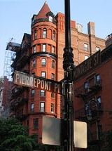
Brooklyn Heights Historic District
Encyclopedia
Brooklyn Heights Historic District is a historic district
that comprises much of Brooklyn Heights. It was named a National Historic Landmark
in January, 1965, designated a New York City Landmark in November, 1965, and added to the National Register of Historic Places
in October, 1966.
The district is bounded by Cadman Plaza West (Old Fulton Street) on the north, the Brooklyn-Queens Expressway on the west, Atlantic Avenue
on the south, and an irregular line that partly follows Clinton and Henry Streets on the east.
Historic district
A historic district or heritage district is a section of a city which contains older buildings considered valuable for historical or architectural reasons. In some countries, historic districts receive legal protection from development....
that comprises much of Brooklyn Heights. It was named a National Historic Landmark
National Historic Landmark
A National Historic Landmark is a building, site, structure, object, or district, that is officially recognized by the United States government for its historical significance...
in January, 1965, designated a New York City Landmark in November, 1965, and added to the National Register of Historic Places
National Register of Historic Places
The National Register of Historic Places is the United States government's official list of districts, sites, buildings, structures, and objects deemed worthy of preservation...
in October, 1966.
The district is bounded by Cadman Plaza West (Old Fulton Street) on the north, the Brooklyn-Queens Expressway on the west, Atlantic Avenue
Atlantic Avenue (New York City)
Atlantic Avenue is an important street in the New York City boroughs of Brooklyn and Queens. It stretches from the Brooklyn waterfront on the East River all the way to Jamaica, Queens...
on the south, and an irregular line that partly follows Clinton and Henry Streets on the east.

