Buchanan County, Iowa
Encyclopedia
2010 census
The 2010 census recorded a population of 20,958 in the county, with a population density of . There were 8,968 housing units, of which 8,161 were occupied.2000 census

Census
A census is the procedure of systematically acquiring and recording information about the members of a given population. It is a regularly occurring and official count of a particular population. The term is used mostly in connection with national population and housing censuses; other common...
of 2000, there were 21,093 people, 7,933 households, and 5,672 families residing in the county. The population density
Population density
Population density is a measurement of population per unit area or unit volume. It is frequently applied to living organisms, and particularly to humans...
was 37 people per square mile (14/km²). There were 8,697 housing units at an average density of 15 per square mile (6/km²). The racial makeup of the county was 98.41% White
Race (United States Census)
Race and ethnicity in the United States Census, as defined by the Federal Office of Management and Budget and the United States Census Bureau, are self-identification data items in which residents choose the race or races with which they most closely identify, and indicate whether or not they are...
, 0.27% Black
Race (United States Census)
Race and ethnicity in the United States Census, as defined by the Federal Office of Management and Budget and the United States Census Bureau, are self-identification data items in which residents choose the race or races with which they most closely identify, and indicate whether or not they are...
or African American
Race (United States Census)
Race and ethnicity in the United States Census, as defined by the Federal Office of Management and Budget and the United States Census Bureau, are self-identification data items in which residents choose the race or races with which they most closely identify, and indicate whether or not they are...
, 0.21% Native American
Race (United States Census)
Race and ethnicity in the United States Census, as defined by the Federal Office of Management and Budget and the United States Census Bureau, are self-identification data items in which residents choose the race or races with which they most closely identify, and indicate whether or not they are...
, 0.40% Asian
Race (United States Census)
Race and ethnicity in the United States Census, as defined by the Federal Office of Management and Budget and the United States Census Bureau, are self-identification data items in which residents choose the race or races with which they most closely identify, and indicate whether or not they are...
, 0.16% from other races
Race (United States Census)
Race and ethnicity in the United States Census, as defined by the Federal Office of Management and Budget and the United States Census Bureau, are self-identification data items in which residents choose the race or races with which they most closely identify, and indicate whether or not they are...
, and 0.54% from two or more races. 0.62% of the population were Hispanic
Race (United States Census)
Race and ethnicity in the United States Census, as defined by the Federal Office of Management and Budget and the United States Census Bureau, are self-identification data items in which residents choose the race or races with which they most closely identify, and indicate whether or not they are...
or Latino
Race (United States Census)
Race and ethnicity in the United States Census, as defined by the Federal Office of Management and Budget and the United States Census Bureau, are self-identification data items in which residents choose the race or races with which they most closely identify, and indicate whether or not they are...
of any race.
There were 7,933 households out of which 34.50% had children under the age of 18 living with them, 60.70% were married couples
Marriage
Marriage is a social union or legal contract between people that creates kinship. It is an institution in which interpersonal relationships, usually intimate and sexual, are acknowledged in a variety of ways, depending on the culture or subculture in which it is found...
living together, 7.40% had a female householder with no husband present, and 28.50% were non-families. 24.70% of all households were made up of individuals and 12.50% had someone living alone who was 65 years of age or older. The average household size was 2.61 and the average family size was 3.13.
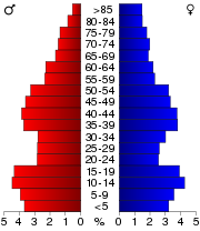
In the county the population was spread out with 28.60% under the age of 18, 8.10% from 18 to 24, 26.30% from 25 to 44, 22.50% from 45 to 64, and 14.50% who were 65 years of age or older. The median age was 36 years. For every 100 females there were 98.70 males. For every 100 females age 18 and over, there were 94.40 males.
The median income for a household in the county was $38,036, and the median income for a family was $45,421. Males had a median income of $30,212 versus $22,356 for females. The per capita income
Per capita income
Per capita income or income per person is a measure of mean income within an economic aggregate, such as a country or city. It is calculated by taking a measure of all sources of income in the aggregate and dividing it by the total population...
for the county was $18,405. About 6.80% of families and 9.40% of the population were below the poverty line, including 12.90% of those under age 18 and 7.60% of those age 65 or over.
Cities
|
Independence, Iowa Independence is a city in and the county seat of Buchanan County, Iowa, United States. The population was 5,966 in the 2010 census, a decline from 6,014 in the 2000 census... Jesup, Iowa Jesup is a city in Black Hawk and Buchanan Counties in the U.S. state of Iowa. The population was 2,212 at the 2000 census.The Black Hawk County portion of Jesup is part of the Waterloo–Cedar Falls Metropolitan Statistical Area.-Geography:... Lamont, Iowa Lamont is a city in Buchanan County, Iowa, United States. The population was 503 at the 2000 census.-Geography:Lamont is located at .According to the United States Census Bureau, the city has a total area of , all of it land.... Quasqueton, Iowa Quasqueton is a city in Buchanan County, Iowa, United States. The population was 574 at the 2000 census. Just northwest of the town is Cedar Rock, a home designed by Frank Lloyd Wright, which is maintained by the state as a museum.-Geography:... |
Rowley, Iowa Rowley is a city in Buchanan County, Iowa, United States. The population was 290 at the 2000 census.-Geography:Rowley is located at .According to the United States Census Bureau, the city has a total area of , all of it land.... Stanley, Iowa Stanley is a city in Buchanan and Fayette Counties in the U.S. state of Iowa. The population was 128 at the 2000 census.-Geography:Stanley is located at .... Winthrop, Iowa Winthrop is a city in Buchanan County, Iowa, United States. The population was 772 at the 2000 census.-Geography:Winthrop is located at .According to the United States Census Bureau, the city has a total area of , all of it land.... |
Other localities
|
Littleton, Iowa Littleton is an unincorporated community in Buchanan County, Iowa, United States, northwest of Independence. Littleton lies in section 9 of Perry Township. The town had 250 persons in 1960, the latest year for which a census is available.-History:... Monti, Iowa Monti is a tiny unincorporated community located in the southeast corner of Buchanan County, Iowa, United States. Founded in the 1880s and platted in 1905, the community lies on the west bank of Buffalo Creek east of Quasqueton and west of Ryan.... |
Otterville, Iowa Otterville is a small unincorporated community in Buchanan County, Iowa, United States, northwest of Independence. Although the community was founded in the 19th century, the townsfolk never incorporated. Otterville remains a sleepy fishing community halfway between Independence and Littleton.... Shady Grove, Iowa Shady Grove is a former townsite and unincorporated community in Buchanan County, Iowa, United States, between the cities of Brandon and Jesup. Settlement of Shady Grove began in 1857, but with the advent of rural migration, the population had dropped to 25 by the 1950s... |

Amish
The Amish , sometimes referred to as Amish Mennonites, are a group of Christian church fellowships that form a subgroup of the Mennonite churches...
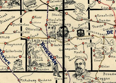
. Several towns named Middlefield existed southeast of Winthrop, but none are populated today. Newtonville was located a few miles south of Monti. The houses at Castleville were later moved to Aurora. Wise, once located between Independence and Jesup just north of Highway 939, was a train-stop between the 1920s and the 1950s. Little remains at the site. Kiene was founded in 1911 between Quasqueton and Monti, but was empty by 1955. Few or even no houses remain at any of these sites.
Townships
Buchanan County is divided into sixteen townshipsTownship (United States)
A township in the United States is a small geographic area. Townships range in size from 6 to 54 square miles , with being the norm.The term is used in three ways....
:
|
Homer Township, Buchanan County, Iowa Homer Township is one of sixteen townships in Buchanan County, Iowa, USA. As of the 2000 census, its population was 681.-Geography:Homer Township covers an area of and contains one incorporated settlement, Rowley. According to the USGS, it contains two cemeteries: Clayton and Rowley.-External... Jefferson Township, Buchanan County, Iowa Jefferson Township is one of sixteen townships in Buchanan County, Iowa, USA. As of the 2000 census, its population was 726.-Geography:Jefferson Township covers an area of and contains one incorporated settlement, Brandon. The unincorporated community of Shady Grove is at the northwestern edge of... Liberty Township, Buchanan County, Iowa Liberty Township is one of sixteen townships in Buchanan County, Iowa, USA. As of the 2000 census, its population was 1,133.-Geography:Liberty Township covers an area of and contains one incorporated settlement, Quasqueton. According to the USGS, it contains four cemeteries: Hickory Grove, Pine... Madison Township, Buchanan County, Iowa Madison Township is one of sixteen townships in Buchanan County, Iowa, USA. As of the 2000 census, its population was 768.-Geography:Madison Township covers an area of and contains one incorporated settlement, Lamont. According to the USGS, it contains two cemeteries: Campton and... Middlefield Township, Buchanan County, Iowa Middlefield Township is one of sixteen townships in Buchanan County, Iowa, USA. As of the 2000 census, its population was 304.-Geography:Middlefield Township covers an area of and contains no incorporated settlements.-External links:* *... Newton Township, Buchanan County, Iowa Newton Township is one of sixteen townships in Buchanan County, Iowa, USA. As of the 2000 census, its population was 423.-Geography:Newton Township covers an area of and contains no incorporated settlements. The unincorporated community of Monti is in the northern portion of the township. Other... |
Perry Township, Buchanan County, Iowa Perry Township is one of sixteen townships in Buchanan County, Iowa, USA. As of the 2000 census, its population was 3,044.-Geography:Perry Township covers an area of and contains one incorporated settlement, Jesup. The unincorporated community of Littleton is also in the township... Sumner Township, Buchanan County, Iowa Sumner Township is one of sixteen townships in Buchanan County, Iowa, USA. As of the 2000 census, its population was 3,148.-Geography:Sumner Township covers an area of and contains the southern half of the city of Independence. According to the USGS, it contains four cemeteries: Mount Hope,... Washington Township, Buchanan County, Iowa Washington Township is one of sixteen townships in Buchanan County, Iowa, USA. As of the 2000 census, its population was 4,540.-Geography:Washington Township covers an area of and contains one incorporated settlement, Independence . The unincorporated community of Otterville also lies in the... Westburg Township, Buchanan County, Iowa Westburg Township is one of sixteen townships in Buchanan County, Iowa, USA. As of the 2010 census, its population was 513. -Geography:Westburg Township covers an area of and contains no incorporated settlements.-External links:* *... |

