Bugbrooke
Encyclopedia

Village
A village is a clustered human settlement or community, larger than a hamlet with the population ranging from a few hundred to a few thousand , Though often located in rural areas, the term urban village is also applied to certain urban neighbourhoods, such as the West Village in Manhattan, New...
and civil parish in Northamptonshire
Northamptonshire
Northamptonshire is a landlocked county in the English East Midlands, with a population of 629,676 as at the 2001 census. It has boundaries with the ceremonial counties of Warwickshire to the west, Leicestershire and Rutland to the north, Cambridgeshire to the east, Bedfordshire to the south-east,...
, England, on a ridge overlooking the valley of the River Nene
River Nene
The River Nene is a river in the east of England that rises from three sources in the county of Northamptonshire. The tidal river forms the border between Cambridgeshire and Norfolk for about . It is the tenth longest river in the United Kingdom, and is navigable for from Northampton to The...
.
Location
It is about 7 miles (11.3 km) south west of NorthamptonNorthampton
Northampton is a large market town and local government district in the East Midlands region of England. Situated about north-west of London and around south-east of Birmingham, Northampton lies on the River Nene and is the county town of Northamptonshire. The demonym of Northampton is...
. The M1
M1 motorway
The M1 is a north–south motorway in England primarily connecting London to Leeds, where it joins the A1 near Aberford. While the M1 is considered to be the first inter-urban motorway to be completed in the United Kingdom, the first road to be built to motorway standard in the country was the...
, one of the busiest motorways in the United Kingdom
United Kingdom
The United Kingdom of Great Britain and Northern IrelandIn the United Kingdom and Dependencies, other languages have been officially recognised as legitimate autochthonous languages under the European Charter for Regional or Minority Languages...
is about 2 miles (3.2 km) by the shortest route to junction 16.
Demographics
The 2001 censusCensus
A census is the procedure of systematically acquiring and recording information about the members of a given population. It is a regularly occurring and official count of a particular population. The term is used mostly in connection with national population and housing censuses; other common...
shows a population of 2,773 people, 1,376 males and 1,397 female in 1,029 households. The 2010 population estimate is 2,924 and the district council has classified it as able to expand further.
Governance
Following boundary changes, Bugbrooke remains part of the Parliamentary Constituency of DaventryDaventry (UK Parliament constituency)
Daventry is a county constituency represented in the House of Commons of the Parliament of the United Kingdom. It is a strongly Conservative seat.- Boundaries :The constituency covers the west of Northamptonshire and is named for the market town of Daventry...
. It is considered a "safe" Conservative seat. At the May 2010 General Election, the Daventry seat was retained by the Conservative candidate, Mr. Christopher Heaton Harris.
Bugbrooke is in South Northamptonshire Council's two-member "Heyfords and Bugbrooke" ward, covering the village as well as neighbouring Nether Heyford
Nether Heyford
Nether Heyford is an English village west of Northampton off the A45 road, in the shire county of Northamptonshire, known as "Northants". It is by road to the M1 London to Yorkshire motorway junction 16, north of London and southeast of Birmingham...
and Upper Heyford
Upper Heyford
Upper Heyford may refer to:*Upper Heyford, Northamptonshire*Upper Heyford, Oxfordshire*RAF Upper Heyford, Oxfordshire...
.
Bugbrooke Parish Council, meets monthly and is re-elected every four years.
Facilities
Bugbrooke has an Anglican church, dedicated to St Michael and All Angels; a BaptistBaptist
Baptists comprise a group of Christian denominations and churches that subscribe to a doctrine that baptism should be performed only for professing believers , and that it must be done by immersion...
chapel; three pubs
Public house
A public house, informally known as a pub, is a drinking establishment fundamental to the culture of Britain, Ireland, Australia and New Zealand. There are approximately 53,500 public houses in the United Kingdom. This number has been declining every year, so that nearly half of the smaller...
("The Bakers Arms" in the High Street, "The Wharf" alongside the Grand Union Canal and "The Five Bells" opposite the church) and a GP Practice,
Bugbrooke Community Primary School is located in the High Street, and a large comprehensive school
Comprehensive school
A comprehensive school is a state school that does not select its intake on the basis of academic achievement or aptitude. This is in contrast to the selective school system, where admission is restricted on the basis of a selection criteria. The term is commonly used in relation to the United...
, Campion School
Campion School (Bugbrooke)
The Campion School is a co-educational comprehensive school in Bugbrooke, about from Northampton, England. Founded in 1967, it has been a Language College since September 1997. In 2011, the school became an academy....
, serving Bugbrooke and several nearby villages, is situated on Kislingbury Road on the eastern approach to the village.
There is a large, modern community centre at Camp Close on the southern edge of the village. Adjacent to this is a large sports field. Sports groups include well-supported Rugby Football
Rugby football
Rugby football is a style of football named after Rugby School in the United Kingdom. It is seen most prominently in two current sports, rugby league and rugby union.-History:...
, Association Football, Bowls and Cricket clubs.
A village magazine, "Bugrooke Link", is published monthly, and includes regular reporting of Church, Parish Council and sports events.
History

Domesday Book
Domesday Book , now held at The National Archives, Kew, Richmond upon Thames in South West London, is the record of the great survey of much of England and parts of Wales completed in 1086...
of 1086 AD as "Buchebroc", is situated on the Hoarestone Brook, which flows through the village from south to north. The name of the stream is supposed to be a corruption of Horse-stone, as an old packhorse
Packhorse
.A packhorse or pack horse refers generally to an equid such as a horse, mule, donkey or pony used for carrying goods on their backs, usually carried in sidebags or panniers. Typically packhorses are used to cross difficult terrain, where the absence of roads prevents the use of wheeled vehicles. ...
route crossed the brook by a simple slab bridge
Clapper bridge
A clapper bridge is an ancient form of bridge found on the moors of Devon and in other upland areas of the United Kingdom including Snowdonia and Anglesey...
just outside the village. When the stream was widened in the 1970s, the last of the mediaeval slabs was damaged beyond repair, but the pillars are still intact.
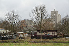
The brook meets the River Nene near Bugbrooke Mill. The first mill on the site was established in 800 AD and by the time of the Domesday Book was the third-highest rated mill in England. It is now the site of Heygate's flour mill, whose large central tower can be seen for several miles around. Heygate's trucks, with their distinctive maroon
Maroon (color)
Maroon is a dark red color.-Etymology:Maroon is derived from French marron .The first recorded use of maroon as a color name in English was in 1789.-Maroon :...
markings, can frequently be seen rumbling along Bugbrooke's main road.
Other features
The West Coast Main LineWest Coast Main Line
The West Coast Main Line is the busiest mixed-traffic railway route in Britain, being the country's most important rail backbone in terms of population served. Fast, long-distance inter-city passenger services are provided between London, the West Midlands, the North West, North Wales and the...
railway and the Grand Union Canal
Grand Union Canal
The Grand Union Canal in England is part of the British canal system. Its main line connects London and Birmingham, stretching for 137 miles with 166 locks...
run adjacent to the south-west of the parish, with the A5 Trunk road a little further distant in this direction, while the M1 motorway runs to the north-east.
Bugbrooke is also the birthplace of the Jesus Army
Jesus Army
The Jesus Army is the identity that the Jesus Fellowship Church uses in its outreach and street-based work. It is a neocharismatic evangelical Christian movement based in the United Kingdom, that is part of the British New Church Movement....
, which sprang out of the Baptist Chapel in the centre of the village, which it continues to use regularly.
Northampton's Express Lift Tower
Express Lift Tower
The National Lift Tower is a lift testing tower built by the Express Lift Company off the Weedon Road in Northampton, England...
can be seen from the village about 5 miles (8 km) to the east.

