Buller River
Encyclopedia

South Island
The South Island is the larger of the two major islands of New Zealand, the other being the more populous North Island. It is bordered to the north by Cook Strait, to the west by the Tasman Sea, to the south and east by the Pacific Ocean...
of New Zealand
New Zealand
New Zealand is an island country in the south-western Pacific Ocean comprising two main landmasses and numerous smaller islands. The country is situated some east of Australia across the Tasman Sea, and roughly south of the Pacific island nations of New Caledonia, Fiji, and Tonga...
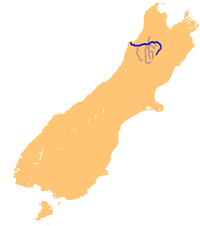
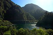
. One of the country's longest rivers, it flows for 170 kilometres from Lake Rotoiti through the Buller Gorge
Buller Gorge
The Buller Gorge is a gorge located in the northwest of the South Island of New Zealand. The Buller River flows through the deep canyon between Murchison and Westport. Land Information New Zealand lists two sections for the gorge, Upper Buller Gorge and Lower Buller Gorge. State Highway 6 runs...
and into the Tasman Sea
Tasman Sea
The Tasman Sea is the large body of water between Australia and New Zealand, approximately across. It extends 2,800 km from north to south. It is a south-western segment of the South Pacific Ocean. The sea was named after the Dutch explorer Abel Janszoon Tasman, the first recorded European...
near the town of Westport
Westport, New Zealand
-Economy:Economic activity is based around fishing, coal mining and dairy farming. Historically, gold mining was a major industry, and coal mining was much more extensive than today . However, the region still is home to New Zealand's largest opencast mining operation in Stockton...
. As Rotoiti itself is fed by the Travers River
Travers River
The Travers River is in the South Island of New Zealand.It lies within the borders of the Nelson Lakes National Park. The valley through which the river flows is popular with trampers and is part of the Travers-Sabine tramping circuit, which follows a major portion of the river, starting from Kerr...
it can be claimed that the Buller's source is at the headwaters of the Travers, on the northern slopes of Mount Travers in the Saint Arnaud Range
Saint Arnaud Range
The Saint Arnaud Range is a mountain range in the central north of New Zealand's South Island. It lies between Lake Rotoiti and the upper reaches of the Wairau River, and marks the eastern boundary of Nelson Lakes National Park....
. The Paparoa Range separates the Buller River from the Grey River
Grey River
The Grey River / Māwheranui is located in the northwest of the South Island of New Zealand. It rises in Lake Christabel, one of numerous small lakes on the western side of the Southern Alps,12 kilometres southwest of the Lewis Pass, and runs westward for 120 kilometres before draining into the...
. A number of flora and fauna are found in the Buller watershed, many of these extending onto the slopes of the Paparoa Range.
The Maori
Maori language
Māori or te reo Māori , commonly te reo , is the language of the indigenous population of New Zealand, the Māori. It has the status of an official language in New Zealand...
name for the Buller. Kawatiri. is rarely used.
The Buller River upstream from Murchison
Murchison, New Zealand
Murchison is a town in the Tasman Region of the South Island of New Zealand. It is near the western end of the "Four Rivers Plain", at the confluence of the Buller River and the Matakitaki River...
along with the Mangles River
Mangles River
The Mangles River is in the South Island of New Zealand. It feeds into the Buller River near the town of Murchison. The river is popular destination for kayaking....
are popular for whitewater kayaking
Whitewater kayaking
Whitewater kayaking is the sport of paddling a kayak on a moving body of water, typically a whitewater river. Whitewater kayaking can range from simple, carefree gently moving water, to demanding, dangerous whitewater. River rapids are graded like ski runs according to the difficulty, danger or...
and recreational fishing
Fishing
Fishing is the activity of trying to catch wild fish. Fish are normally caught in the wild. Techniques for catching fish include hand gathering, spearing, netting, angling and trapping....
. State Highway 6
New Zealand State Highway network
The New Zealand State Highway network is the major national highway network in New Zealand. Just under 100 roads in both the North and South Islands are State Highways...
follows the river for much of its length.
This river has an annual mean flow of 429m3/s and boasts the highest flood flow of any New Zealand river which is over 14,000m3/s.
Tributaries

Gowan River
The Gowan River is in the South Island of New Zealand. Its source is at Lake Rotoroa and travels 11 kilometres before feeding into the Buller River. Mixed farming and forestry occurs on both banks of the river...
, the Matakitaki River
Matakitaki River
The Matakitaki River is located in the north of New Zealand's South Island. An upper tributary of the Buller River, it flows north and west for 65 kilometres from its source north of the Lewis Pass, joining the Buller at Murchison...
, the Maruia River
Maruia River
The Maruia River is located in the northwestern South Island of New Zealand. It is a major tributary of the Buller River, flowing for 80 kilometres before joining the larger river eight kilometres to the west of Murchison....
, and the Inangahua River
Inangahua River
The Inangahua River is located in the northwest of New Zealand’s South Island. It is a major tributary of the Buller River, which it joins at the town of Inangahua Junction....
. Other smaller tributaries include the Hope, Owen
Owen River, New Zealand
The Owen River is located in the northwest of New Zealand's South Island. This short river is an upper tributary of the Buller River. It flows south for 20 kilometres from its headwaters on the slopes of Mount Owen, flowing into the Buller at the small settlement of Owen River 18 kilometres...
, Mangles
Mangles River
The Mangles River is in the South Island of New Zealand. It feeds into the Buller River near the town of Murchison. The river is popular destination for kayaking....
, Matiri
Matiri River
The Matiri River is a river located in the northwest of New Zealand's South Island.It runs south for 30 kilometres from its headwaters west of Mount Owen in Kahurangi National Park to its confluence with the Buller River just below the town of Murchison. Halfway along its length, it passes through...
, Blackwater
Blackwater River, New Zealand
The Blackwater River is in the South Island of New Zealand, flowing into the Buller River between Westport and Inangahua Junction. The river was named due to the dark coloured waters the Māori discovered....
, and Ohikanui River
Ohikanui River
The Ohikanui River is a tributary of the Buller River in New Zealand's South Island. It flows north for 20 kilometres, joining the Buller 14 kilometres from its outflow into the Tasman Sea...
s.
In July 2001 the Buller Water Conservation Order
Water Conservation Order
A water conservation order is a legal ruling to protect aspects of water bodies. It may be to protect the quantity of the water itself or for any issues relating to the water body as a whole.-New Zealand:...
came into force, listing the waters of the Buller River and tributaries that are to be retained in their natural state or protected because of the outstanding characteristics, features and values of the waters.
The river is named after Charles Buller
Charles Buller
Charles Buller , was a British barrister, politician and reformer.-Background and education:Born in Calcutta, British India, Buller was the son of Charles Buller , a member of a well-known Cornish family, and Barbara Isabella Kirkpatrick, daughter of General William Kirkpatrick, considered an...
, Member of Parliament and director of the New Zealand Company
New Zealand Company
The New Zealand Company originated in London in 1837 as the New Zealand Association with the aim of promoting the "systematic" colonisation of New Zealand. The association, and later the company, intended to follow the colonising principles of Edward Gibbon Wakefield, who envisaged the creation of...
.

