

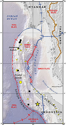
Burma Plate
Encyclopedia
Southeast Asia
Southeast Asia, South-East Asia, South East Asia or Southeastern Asia is a subregion of Asia, consisting of the countries that are geographically south of China, east of India, west of New Guinea and north of Australia. The region lies on the intersection of geological plates, with heavy seismic...
, often considered a part of the larger Eurasian Plate
Eurasian Plate
The Eurasian Plate is a tectonic plate which includes most of the continent of Eurasia , with the notable exceptions of the Indian subcontinent, the Arabian subcontinent, and the area east of the Chersky Range in East Siberia...
. The Andaman Islands
Andaman Islands
The Andaman Islands are a group of Indian Ocean archipelagic islands in the Bay of Bengal between India to the west, and Burma , to the north and east...
, Nicobar Islands
Nicobar Islands
The Nicobar Islands are an archipelagic island chain in the eastern Indian Ocean...
, and northwestern Sumatra
Sumatra
Sumatra is an island in western Indonesia, westernmost of the Sunda Islands. It is the largest island entirely in Indonesia , and the sixth largest island in the world at 473,481 km2 with a population of 50,365,538...
are located on the plate. This island arc
Island arc
An island arc is a type of archipelago composed of a chain of volcanoes which alignment is arc-shaped, and which are situated parallel and close to a boundary between two converging tectonic plates....
separates the Andaman Sea
Andaman Sea
The Andaman Sea or Burma Sea is a body of water to the southeast of the Bay of Bengal, south of Burma, west of Thailand and east of the Andaman Islands, India; it is part of the Indian Ocean....
from the main Indian Ocean
Indian Ocean
The Indian Ocean is the third largest of the world's oceanic divisions, covering approximately 20% of the water on the Earth's surface. It is bounded on the north by the Indian Subcontinent and Arabian Peninsula ; on the west by eastern Africa; on the east by Indochina, the Sunda Islands, and...
to the west.
To its east lies the Sunda Plate
Sunda Plate
The Sunda Plate is the tectonic plate on which the majority of Southeast Asia is located. It was formerly considered a part of the Eurasian Plate, but GPS measurements have confirmed its independent movement at 10 mm/yr eastward relative to Eurasia...
, from which it is separated along a transform boundary, running in a rough north-south line through the Andaman Sea. This boundary between the Burma and Sunda plates is a marginal seafloor spreading centre
Seafloor spreading
Seafloor spreading is a process that occurs at mid-ocean ridges, where new oceanic crust is formed through volcanic activity and then gradually moves away from the ridge. Seafloor spreading helps explain continental drift in the theory of plate tectonics....
, which has led to the opening up of the Andaman Sea (from a southerly direction) by "pushing out" the Andaman-Nicobar-Sumatra island arc
Island arc
An island arc is a type of archipelago composed of a chain of volcanoes which alignment is arc-shaped, and which are situated parallel and close to a boundary between two converging tectonic plates....
from mainland Asia, a process which began in earnest approximately 4 million years ago.
To the west is the much larger India Plate
India Plate
The India Plate or Indian Plate is a tectonic plate that was originally a part of the ancient continent of Gondwanaland from which it split off, eventually becoming a major plate. About 50 to 55 million years ago , it fused with the adjacent Australian Plate...
, which is subducting beneath the eastern facet of the Burma Plate. This extensive subduction zone
Subduction
In geology, subduction is the process that takes place at convergent boundaries by which one tectonic plate moves under another tectonic plate, sinking into the Earth's mantle, as the plates converge. These 3D regions of mantle downwellings are known as "Subduction Zones"...
has formed the Sunda Trench.
Tectonic history
In models of the reconstructed tectonic history of the area, the generally northwards movement of the Indo-Australian PlateIndo-Australian Plate
The Indo-Australian Plate is a major tectonic plate that includes the continent of Australia and surrounding ocean, and extends northwest to include the Indian subcontinent and adjacent waters...
resulted in its substantive collision with the Eurasia
Eurasia
Eurasia is a continent or supercontinent comprising the traditional continents of Europe and Asia ; covering about 52,990,000 km2 or about 10.6% of the Earth's surface located primarily in the eastern and northern hemispheres...
n continent
Continent
A continent is one of several very large landmasses on Earth. They are generally identified by convention rather than any strict criteria, with seven regions commonly regarded as continents—they are : Asia, Africa, North America, South America, Antarctica, Europe, and Australia.Plate tectonics is...
, which began during the Eocene
Eocene
The Eocene Epoch, lasting from about 56 to 34 million years ago , is a major division of the geologic timescale and the second epoch of the Paleogene Period in the Cenozoic Era. The Eocene spans the time from the end of the Palaeocene Epoch to the beginning of the Oligocene Epoch. The start of the...
epoch, approximately 50-55 million years ago (Ma). This collision of the India Plate portion with Asia began the orogenic uplift
Orogeny
Orogeny refers to forces and events leading to a severe structural deformation of the Earth's crust due to the engagement of tectonic plates. Response to such engagement results in the formation of long tracts of highly deformed rock called orogens or orogenic belts...
which has formed the Himalaya mountains.
As the India Plate drifted
Continental drift
Continental drift is the movement of the Earth's continents relative to each other. The hypothesis that continents 'drift' was first put forward by Abraham Ortelius in 1596 and was fully developed by Alfred Wegener in 1912...
northwards at a relatively rapid rate of an average 16 cm/yr, it also rotated in an counter-clockwise direction. As a result of this movement and rotation, the convergence
Convergent boundary
In plate tectonics, a convergent boundary, also known as a destructive plate boundary , is an actively deforming region where two tectonic plates or fragments of lithosphere move toward one another and collide...
along the plate's eastern boundary (the Burma-Andaman-Malay region) with Eurasia was at an oblique angle.
The transform forces along this subduction front started the clockwise bending of the Sunda arc; in the late Oligocene
Oligocene
The Oligocene is a geologic epoch of the Paleogene Period and extends from about 34 million to 23 million years before the present . As with other older geologic periods, the rock beds that define the period are well identified but the exact dates of the start and end of the period are slightly...
(ca. 32 Ma) further faulting developed and the Burma and Sunda microplates began to "break off" from the larger Eurasian plate.
After a further series of transform faulting, and the continuing subduction of the India Plate beneath the Burma plate, backarc spreading saw the formation of the marginal basin and seafloor spreading centre which would become the Andaman Sea, a process well-underway by the mid-Pliocene
Pliocene
The Pliocene Epoch is the period in the geologic timescale that extends from 5.332 million to 2.588 million years before present. It is the second and youngest epoch of the Neogene Period in the Cenozoic Era. The Pliocene follows the Miocene Epoch and is followed by the Pleistocene Epoch...
(3-4 Ma).
Recent tectonic activity
On December 26, 2004, a large portion of the boundary between the Burma Plate and the Indo-Australian Plate slipped, causing the 2004 Indian Ocean earthquake2004 Indian Ocean earthquake
The 2004 Indian Ocean earthquake was an undersea megathrust earthquake that occurred at 00:58:53 UTC on Sunday, December 26, 2004, with an epicentre off the west coast of Sumatra, Indonesia. The quake itself is known by the scientific community as the Sumatra-Andaman earthquake...
. This megathrust earthquake
Megathrust earthquake
Megathrust earthquakes occur at subduction zones at destructive plate boundaries , where one tectonic plate is forced under another. Due to the shallow dip of the plate boundary, which causes large sections to get stuck, these earthquakes are among the world's largest, with moment magnitudes ...
had a magnitude
Moment magnitude scale
The moment magnitude scale is used by seismologists to measure the size of earthquakes in terms of the energy released. The magnitude is based on the seismic moment of the earthquake, which is equal to the rigidity of the Earth multiplied by the average amount of slip on the fault and the size of...
of 9.3. Over 1600 km of the boundary underwent thrust fault
Thrust fault
A thrust fault is a type of fault, or break in the Earth's crust across which there has been relative movement, in which rocks of lower stratigraphic position are pushed up and over higher strata. They are often recognized because they place older rocks above younger...
ing and shifted an average of 15 m, with the sea floor being uplifted several meters. This rise in the sea floor generated a massive tsunami
Tsunami
A tsunami is a series of water waves caused by the displacement of a large volume of a body of water, typically an ocean or a large lake...
that killed approximately 229,800 people along the coast of the Indian Ocean.