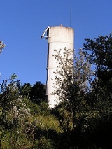
Burrewarra Point
Encyclopedia
Burrewarra Point is to the north of Broulee
and 25 kilometers to the south of Batemans Bay
on the south coast of New South Wales
, Australia
.
An active lighthouse, Burrewarra Point Light
, is located at Burrewarra Point. It was built in 1974.
Also can be found at Burrewarra Point are the remains of concrete igloo buildings of No. 17 Radar Station
used by the Royal Australian Air Force
during World War II
. Also present at the location is a commemorative plaque.
Broulee, New South Wales
Broulee is a town on the south coast of New South Wales between Batemans Bay and Moruya. In 2006, the town had a population of 1,292 people. Just off the beach is a Broulee Island, currently joined to the mainland, but in past years the connecting spit has been covered by water, at times a very ...
and 25 kilometers to the south of Batemans Bay
Batemans Bay, New South Wales
- Media :Radio Stations*East Coast Radio 2EC *Power FM NSW South Coast - POWER FM from Nowra can also be received in parts of Batemans Bay on FM 94.9....
on the south coast of New South Wales
New South Wales
New South Wales is a state of :Australia, located in the east of the country. It is bordered by Queensland, Victoria and South Australia to the north, south and west respectively. To the east, the state is bordered by the Tasman Sea, which forms part of the Pacific Ocean. New South Wales...
, Australia
Australia
Australia , officially the Commonwealth of Australia, is a country in the Southern Hemisphere comprising the mainland of the Australian continent, the island of Tasmania, and numerous smaller islands in the Indian and Pacific Oceans. It is the world's sixth-largest country by total area...
.
An active lighthouse, Burrewarra Point Light
Burrewarra Point Light
Burrewarra Point Light is an active lighthouse located at Burrewarra Point, New South Wales, Australia, which is north of Broulee and to the south of Batemans Bay....
, is located at Burrewarra Point. It was built in 1974.
Also can be found at Burrewarra Point are the remains of concrete igloo buildings of No. 17 Radar Station
No. 17 Radar Station RAAF
No. 17 Radar Station RAAF was a Royal Australian Air Force radar station formed at Burrewarra Point, Guerilla Bay, New South Wales, Australia on 12 April 1943. The radar became operational on 29 April 1943 after initial training and setting up the radar equipment.The radar station at Burrewarra...
used by the Royal Australian Air Force
Royal Australian Air Force
The Royal Australian Air Force is the air force branch of the Australian Defence Force. The RAAF was formed in March 1921. It continues the traditions of the Australian Flying Corps , which was formed on 22 October 1912. The RAAF has taken part in many of the 20th century's major conflicts...
during World War II
World War II
World War II, or the Second World War , was a global conflict lasting from 1939 to 1945, involving most of the world's nations—including all of the great powers—eventually forming two opposing military alliances: the Allies and the Axis...
. Also present at the location is a commemorative plaque.

