

California County Routes in zone A
Encyclopedia
There are 27 routes assigned to the "A" zone of the California Route Marker Program, which designates county routes in California
. The "A" zone includes county highways lying in the counties of Lassen
, Plumas
, Shasta
, Siskiyou
, and Tehama
.
.
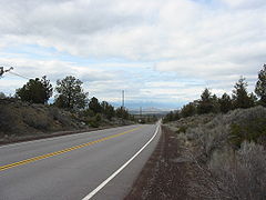 One mile east of the Interstate junction, it passes through the tiny village of Grenada
, the only population center of any merit along the route. 7 miles (11.3 km) further east is the burg Mayten, which consists only of a convenience store
, a church, and an elementary school
.
The route is heavily used by travellers and truckers southbound on Interstate 5 who wish to use US 97 northbound en route to Klamath Falls
and points north. This route saves over 13 miles (20.9 km) than if the alternative routing via I-5 to Weed, then north on US 97 was used. Hence, the local name "97 cutoff".
The western two-thirds of the route passes through agricultural areas, and is very reminiscent of two-lane farm roads in California's Central Valley. However, the eastern portion is very scenic, passing through an area with towering dark red crags and buttes to the north.
connected to SR 36
.
and Johnsville
.
and SR 70
in Portola
.
Road is a county route located in Shasta County
connecting SR 36
to SR 273
in Redding
. Known locally as Ditch Grade Road ;the final 6.5 mile section before the junction with SR 36 closely follows the contour of hillside as this route was previously used to bring water to the mine at Platina. There is a rock formation some 6.5 miles from SR 36 known as Old Man rock or The Lincoln Memorial .
and SR 44
.
connecting SR 273
(as well as Interstate 5
and SR 299
) in Redding
and Shasta Dam
.
to SR 89
.
connecting SR 89
to CR A19.
and the Sierra Army Depot.
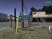 A28 begins in Grenada
, connecting Grenada with Hornbrook
via Montague
. It is a flat, level route, and for this reason, was the original preferred routing for both US 99 and Interstate 5
through the area. In both instances, the routing was changed because of intense lobbying
by officials in Yreka
, who decried the fact that the major highway through the county would bypass the county seat
. Thus, both highways ended up being built over far more rigorous terrain at a huge cost increase.
A28 serves the aforementioned three towns, as well as numerous homes and ranches along the way.
County routes in California
In the U.S. state of California, county routes are controlled and maintained by the respective counties in which they reside. However, they are generally patrolled by the state's California Highway Patrol....
. The "A" zone includes county highways lying in the counties of Lassen
Lassen County, California
Lassen County is a county located in the northeastern portion of the U.S. state of California. As of the 2010 census, the population was 34,895, up from 33,828 at the 2000 census...
, Plumas
Plumas County, California
Plumas County is a county located in the Sierra Nevada of the U.S. state of California. The county gets its name from the Spanish words for the Feather River , which flows through the county. As of the 2010 census, the population 20,007, down from 20,824 at the 2000 census...
, Shasta
Shasta County, California
Shasta County is a county located in the northern portion of the U.S. state of California. The county occupies the northern reaches of the Sacramento Valley, with portions extending into the southern reaches of the Cascade Range. As of the 2010 census, the population was 177,223, up from 163,256...
, Siskiyou
Siskiyou County, California
Siskiyou County is a county located in the far northernmost part of the U.S. state of California, in the Shasta Cascade region on the Oregon border. Yreka is the county seat. Because of its substantial natural beauty, outdoor recreation opportunities, and Gold Rush era history, it is an important...
, and Tehama
Tehama County, California
Tehama County is a county located in the northern part of the U.S. state of California. It is bisected by the Sacramento River. As of 2010 its population was 63,463, up from 56,039 as of 2000. The county seat is Red Bluff.-History:...
.
A1
County Route A12, known locally as the "99-97 cutoff", or more commonly, "the 97 cutoff", is a two-lane rural highway with a length of 17.9 miles (28.8 km). A12 begins in the west at its junction with Old 99 Highway, which was once US 99. Just a few dozen yards to the east, it intersects Interstate 5. Its eastern terminus is at US 97, 12 miles (19.3 km) north of WeedWeed, California
Weed is a city located in Siskiyou County, California. As of the 2010 Census, the town had a total population of 2,967, down from 2,979 at the 2000 census. There are several unincorporated communities adjacent to, or just outside Weed proper. These include Edgewood, Carrick, Lake Shastina, Rancho...
.
Grenada, California
Grenada is a census-designated place in Siskiyou County, California, United States. The population was 367 at the 2010 census, up from 351 at the 2000 census...
, the only population center of any merit along the route. 7 miles (11.3 km) further east is the burg Mayten, which consists only of a convenience store
Convenience store
A convenience store, corner store, corner shop, commonly called a bodega in Spanish-speaking areas of the United States, is a small store or shop in a built up area that stocks a range of everyday items such as groceries, toiletries, alcoholic and soft drinks, and may also offer money order and...
, a church, and an elementary school
Elementary school
An elementary school or primary school is an institution where children receive the first stage of compulsory education known as elementary or primary education. Elementary school is the preferred term in some countries, particularly those in North America, where the terms grade school and grammar...
.
The route is heavily used by travellers and truckers southbound on Interstate 5 who wish to use US 97 northbound en route to Klamath Falls
Klamath Falls, Oregon
Klamath Falls is a city in Klamath County, Oregon, United States. Originally called Linkville when George Nurse founded the town in 1867, after the Link River on whose falls this city sat, although no falls currently exist; the name was changed to Klamath Falls in 1892...
and points north. This route saves over 13 miles (20.9 km) than if the alternative routing via I-5 to Weed, then north on US 97 was used. Hence, the local name "97 cutoff".
The western two-thirds of the route passes through agricultural areas, and is very reminiscent of two-lane farm roads in California's Central Valley. However, the eastern portion is very scenic, passing through an area with towering dark red crags and buttes to the north.
A13
County Route A13, also known as Big Springs Road and Walker Memorial Road, is a road in Plumas CountyPlumas County, California
Plumas County is a county located in the Sierra Nevada of the U.S. state of California. The county gets its name from the Spanish words for the Feather River , which flows through the county. As of the 2010 census, the population 20,007, down from 20,824 at the 2000 census...
connected to SR 36
California State Route 36
State Route 36 is an east–west state highway in the U.S. state of California that is routed from U.S. Route 101 in Humboldt County to U.S. Route 395 just east of Susanville in Lassen County. The portion of SR 36 travelling past Lassen Volcanic National Park and Lake Almanor is part of the...
.
A14
County Route A14 is a road in Plumas County connecting SR 89California State Route 89
State Route 89 is a California State Highway that travels in the north–south direction, and is the major thoroughfare for many mountain communities. It starts from U.S. Route 395 near Topaz Lake, winding its way up to the Monitor Pass, down to the Carson River, and up again over the Luther...
and Johnsville
Johnsville, California
Johnsville is a census-designated place in Plumas County, California, United States. The population was 20 at the 2010 census, down from 21 at the 2000 census.-Geography:Johnsville is located at ....
.
A15
County Route A15 is a road in Plumas County connecting SR 89California State Route 89
State Route 89 is a California State Highway that travels in the north–south direction, and is the major thoroughfare for many mountain communities. It starts from U.S. Route 395 near Topaz Lake, winding its way up to the Monitor Pass, down to the Carson River, and up again over the Luther...
and SR 70
California State Route 70
State Route 70 is a state highway in the U.S. state of California. Connecting Sacramento with U.S. Route 395 near Beckwourth Pass via the Feather River Canyon, it was formerly known as U.S. Route 40 Alternate, crossing the Sierra Nevada at a lower elevation than Donner Pass on U.S. Route 40...
in Portola
Portola, California
Portola is the only incorporated city in Plumas County, California, United States. The population was 2,104 at the 2010 census, down from 2,227 at the 2000 census...
.
A16
County Route A16 or PlatinaPlatina, California
Platina is a small unincorporated community of 200 people in Shasta County, California, approximately and equidistantly 40 miles west of Redding and Red Bluff. Its ZIP Code is 96076. Wired Telephone Numbers follow the pattern 530-352-xxxx.-History:...
Road is a county route located in Shasta County
Shasta County, California
Shasta County is a county located in the northern portion of the U.S. state of California. The county occupies the northern reaches of the Sacramento Valley, with portions extending into the southern reaches of the Cascade Range. As of the 2010 census, the population was 177,223, up from 163,256...
connecting SR 36
California State Route 36
State Route 36 is an east–west state highway in the U.S. state of California that is routed from U.S. Route 101 in Humboldt County to U.S. Route 395 just east of Susanville in Lassen County. The portion of SR 36 travelling past Lassen Volcanic National Park and Lake Almanor is part of the...
to SR 273
California State Route 273
State Route 273 is a state highway in Shasta County, California, USA. The route takes a more direct approach to the cities of Anderson and Redding, passing through their downtown districts. Interstate 5 is a bypass of this route, as it connects both ends. This route was part of former U.S. Route...
in Redding
Redding, California
Redding is a city in far-Northern California. It is the county seat of Shasta County, California, USA. With a population of 89,861, according to the 2010 Census...
. Known locally as Ditch Grade Road ;the final 6.5 mile section before the junction with SR 36 closely follows the contour of hillside as this route was previously used to bring water to the mine at Platina. There is a rock formation some 6.5 miles from SR 36 known as Old Man rock or The Lincoln Memorial .
A17
County Route A17' is a county route in the U.S. State of California, located in Shasta County and Tehama County, connecting I-5Interstate 5 in California
Interstate 5 is a major north–south route of the Interstate Highway System in the U.S. state of California. It begins at the Mexico – United States border at the San Ysidro crossing, goes north across the length of California and crosses into Oregon south of the Medford-Ashland metropolitan...
and SR 44
California State Route 44
State Route 44 is a state highway in the U.S. State of California that travels in an east–west direction from Redding to Lassen Volcanic National Park before ending at Route 36 west of Susanville...
.
A18
County Route A18 is a road in Shasta County on the State Scenic Highway SystemState Scenic Highway System (California)
The State Scenic Highway System is a list of highways, mainly state highways, that have been designated by the California Department of Transportation as scenic highways. The California State Legislature, primarily through Section 263 of the Streets and Highways Code, makes highways eligible for...
connecting SR 273
California State Route 273
State Route 273 is a state highway in Shasta County, California, USA. The route takes a more direct approach to the cities of Anderson and Redding, passing through their downtown districts. Interstate 5 is a bypass of this route, as it connects both ends. This route was part of former U.S. Route...
(as well as Interstate 5
Interstate 5 in California
Interstate 5 is a major north–south route of the Interstate Highway System in the U.S. state of California. It begins at the Mexico – United States border at the San Ysidro crossing, goes north across the length of California and crosses into Oregon south of the Medford-Ashland metropolitan...
and SR 299
California State Route 299
State Route 299 is a state highway in the U.S. state of California that runs across the northern part of the state. It runs from Arcata on the Pacific Ocean to the border with Nevada. Between Arcata and Redding, Route 299 junctions with State Route 96 and is briefly co-signed with State Route 3. In...
) in Redding
Redding, California
Redding is a city in far-Northern California. It is the county seat of Shasta County, California, USA. With a population of 89,861, according to the 2010 Census...
and Shasta Dam
Shasta Dam
Shasta Dam is an arch dam across the Sacramento River in the northern part of the U.S. state of California, at the north end of the Sacramento Valley. The dam mainly serves long-term water storage and flood control in its reservoir, Shasta Lake, and also generates hydroelectric power...
.
A19
County Route A19 is a county route in Shasta County connecting SR 299California State Route 299
State Route 299 is a state highway in the U.S. state of California that runs across the northern part of the state. It runs from Arcata on the Pacific Ocean to the border with Nevada. Between Arcata and Redding, Route 299 junctions with State Route 96 and is briefly co-signed with State Route 3. In...
to SR 89
California State Route 89
State Route 89 is a California State Highway that travels in the north–south direction, and is the major thoroughfare for many mountain communities. It starts from U.S. Route 395 near Topaz Lake, winding its way up to the Monitor Pass, down to the Carson River, and up again over the Luther...
.
A20
County Route A20 is a county route located in Shasta CountyShasta County, California
Shasta County is a county located in the northern portion of the U.S. state of California. The county occupies the northern reaches of the Sacramento Valley, with portions extending into the southern reaches of the Cascade Range. As of the 2010 census, the population was 177,223, up from 163,256...
connecting SR 89
California State Route 89
State Route 89 is a California State Highway that travels in the north–south direction, and is the major thoroughfare for many mountain communities. It starts from U.S. Route 395 near Topaz Lake, winding its way up to the Monitor Pass, down to the Carson River, and up again over the Luther...
to CR A19.
A21
County route A21, or Mooney Rd. connects California State Route 147 to California State Route 44 and intersects California State Route 36 along the way.A25
This short highway, paired with A26, services HerlongHerlong, California
Herlong is a census-designated place in Lassen County, California. It is located north of Doyle, at an elevation of 4114 feet . Herlong is located in southern Lassen County near the southeast edge of Honey Lake about north of Reno, Nevada, and about south of Susanville. The community is...
and the Sierra Army Depot.
A26
This short highway, paired with A25, serves Herlong and the Sierra Army Depot.A28
County Route A28 is a two-lane rural highway with a length of 20.3 mi (32.7 km).Route description
Grenada, California
Grenada is a census-designated place in Siskiyou County, California, United States. The population was 367 at the 2010 census, up from 351 at the 2000 census...
, connecting Grenada with Hornbrook
Hornbrook, California
Hornbrook is a census-designated place in Siskiyou County, California, United States. The population was 248 at the 2010 census, down from 286 at the 2000 census.-Geography:Hornbrook is located at ....
via Montague
Montague, California
Montague is a city in Siskiyou County, California, United States. The population was 1,443 at the 2010 census, down from 1,456 at the 2000 census.-Geography:Montague is located at ....
. It is a flat, level route, and for this reason, was the original preferred routing for both US 99 and Interstate 5
Interstate 5
Interstate 5 is the main Interstate Highway on the West Coast of the United States, running largely parallel to the Pacific Ocean coastline from Canada to Mexico . It serves some of the largest cities on the U.S...
through the area. In both instances, the routing was changed because of intense lobbying
Lobbying
Lobbying is the act of attempting to influence decisions made by officials in the government, most often legislators or members of regulatory agencies. Lobbying is done by various people or groups, from private-sector individuals or corporations, fellow legislators or government officials, or...
by officials in Yreka
Yreka, California
Yreka is the county seat of Siskiyou County, California, United States. The population was 7,765 at the 2010 census, up from 7,290 at the 2000 census.- History:...
, who decried the fact that the major highway through the county would bypass the county seat
County seat
A county seat is an administrative center, or seat of government, for a county or civil parish. The term is primarily used in the United States....
. Thus, both highways ended up being built over far more rigorous terrain at a huge cost increase.
A28 serves the aforementioned three towns, as well as numerous homes and ranches along the way.