
California gubernatorial election, 1962
Encyclopedia
The California gubernatorial election, 1962 was held on November 6, 1962. The Democratic
incumbent
, Pat Brown
, ran for re-election against former Vice President
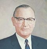
Richard Nixon
. In his concession speech, Nixon accused the media of favoring his opponent Brown and stated that it was his "last press conference" and that "You won't have Nixon to kick around any more." Six years later, Nixon would go on to be elected
President of the United States
.
until Brown's election in 1958. The state voted for Eisenhower
in 1952
and 1956
, and Nixon carried the state over John F. Kennedy
in the 1960 Presidential election
. With two incumbent Republican senators, the Republican Party felt it could gain a governorship and win the state back from the Democrats. They turned to former California Senator and Vice President Richard Nixon, the biggest name at the time in the California Republican Party
. Having been elected Senator and carrying the state against Kennedy in 1960, they also felt a convincing win would be a springboard for Nixon to challenge Kennedy again in 1964, since he narrowly lost to him in 1960.
In a bitter and expensive campaign, Brown and Nixon campaigned with great zeal and effort. Nixon had a big lead in the polls early on, but Brown chipped away at his lead. Still, come election day, Nixon was favored to win a relatively close election. But Brown not only won, but by a surprising 5%. A stunned and frustrated Nixon announced he was retiring from politics.
California Democratic Party
The California Democratic Party is the state branch of the Democratic Party in the state of California, headquartered in Sacramento. It is chaired by veteran Democratic politician and former United States Representative John L. Burton, who succeeded Art Torres in April 2009. It is the majority...
incumbent
Incumbent
The incumbent, in politics, is the existing holder of a political office. This term is usually used in reference to elections, in which races can often be defined as being between an incumbent and non-incumbent. For example, in the 2004 United States presidential election, George W...
, Pat Brown
Pat Brown
Edmund Gerald "Pat" Brown, Sr. was the 32nd Governor of California, serving from 1959 to 1967, and the father of current Governor of California Jerry Brown.-Background:...
, ran for re-election against former Vice President
Vice President of the United States
The Vice President of the United States is the holder of a public office created by the United States Constitution. The Vice President, together with the President of the United States, is indirectly elected by the people, through the Electoral College, to a four-year term...
Richard Nixon
Richard Nixon
Richard Milhous Nixon was the 37th President of the United States, serving from 1969 to 1974. The only president to resign the office, Nixon had previously served as a US representative and senator from California and as the 36th Vice President of the United States from 1953 to 1961 under...
. In his concession speech, Nixon accused the media of favoring his opponent Brown and stated that it was his "last press conference" and that "You won't have Nixon to kick around any more." Six years later, Nixon would go on to be elected
United States presidential election, 1968
The United States presidential election of 1968 was the 46th quadrennial United States presidential election. Coming four years after Democrat Lyndon B. Johnson won in a historic landslide, it saw Johnson forced out of the race and Republican Richard Nixon elected...
President of the United States
President of the United States
The President of the United States of America is the head of state and head of government of the United States. The president leads the executive branch of the federal government and is the commander-in-chief of the United States Armed Forces....
.
Election background
Edmund G. (Pat) Brown Sr. was a relatively popular Democratic governor in California who was first elected in 1958. At the time, California was generally considered a Republican stronghold, with Republican governors and senators from the end of World War IIWorld War II
World War II, or the Second World War , was a global conflict lasting from 1939 to 1945, involving most of the world's nations—including all of the great powers—eventually forming two opposing military alliances: the Allies and the Axis...
until Brown's election in 1958. The state voted for Eisenhower
Dwight D. Eisenhower
Dwight David "Ike" Eisenhower was the 34th President of the United States, from 1953 until 1961. He was a five-star general in the United States Army...
in 1952
United States presidential election, 1952
The United States presidential election of 1952 took place in an era when Cold War tension between the United States and the Soviet Union was escalating rapidly. In the United States Senate, Republican Senator Joseph McCarthy of Wisconsin had become a national figure after chairing congressional...
and 1956
United States presidential election, 1956
The United States presidential election of 1956 saw a popular Dwight D. Eisenhower successfully run for re-election. The 1956 election was a rematch of 1952, as Eisenhower's opponent in 1956 was Democrat Adlai Stevenson, whom Eisenhower had defeated four years earlier.Incumbent President Eisenhower...
, and Nixon carried the state over John F. Kennedy
John F. Kennedy
John Fitzgerald "Jack" Kennedy , often referred to by his initials JFK, was the 35th President of the United States, serving from 1961 until his assassination in 1963....
in the 1960 Presidential election
United States presidential election, 1960
The United States presidential election of 1960 was the 44th American presidential election, held on November 8, 1960, for the term beginning January 20, 1961, and ending January 20, 1965. The incumbent president, Republican Dwight D. Eisenhower, was not eligible to run again. The Republican Party...
. With two incumbent Republican senators, the Republican Party felt it could gain a governorship and win the state back from the Democrats. They turned to former California Senator and Vice President Richard Nixon, the biggest name at the time in the California Republican Party
California Republican Party
The California Republican Party is the California affiliate of the United States Republican Party. The party chairman is Tom Del Beccaro and is based in Burbank, California, a suburb of Los Angeles. The RPC also has a headquarters in Sacramento....
. Having been elected Senator and carrying the state against Kennedy in 1960, they also felt a convincing win would be a springboard for Nixon to challenge Kennedy again in 1964, since he narrowly lost to him in 1960.
In a bitter and expensive campaign, Brown and Nixon campaigned with great zeal and effort. Nixon had a big lead in the polls early on, but Brown chipped away at his lead. Still, come election day, Nixon was favored to win a relatively close election. But Brown not only won, but by a surprising 5%. A stunned and frustrated Nixon announced he was retiring from politics.
General election results
Results by county
| County | Brown Pat Brown Edmund Gerald "Pat" Brown, Sr. was the 32nd Governor of California, serving from 1959 to 1967, and the father of current Governor of California Jerry Brown.-Background:... |
Votes | Nixon Richard Nixon Richard Milhous Nixon was the 37th President of the United States, serving from 1969 to 1974. The only president to resign the office, Nixon had previously served as a US representative and senator from California and as the 36th Vice President of the United States from 1953 to 1961 under... |
Votes | Wyckoff | Votes |
|---|---|---|---|---|---|---|
| Plumas Plumas County, California Plumas County is a county located in the Sierra Nevada of the U.S. state of California. The county gets its name from the Spanish words for the Feather River , which flows through the county. As of the 2010 census, the population 20,007, down from 20,824 at the 2000 census... |
66.44% | 3,397 | 31.76% | 1,624 | 1.80% | 92 |
| Trinity Trinity County, California Trinity County is a large, rugged and mountainous, heavily forested county located in the northwestern portion of the U.S. state of California, along the Trinity River and within the Salmon/Klamath Mountains. It covers an area of over two million acres , and as of the 2010 census its population... |
64.58% | 2,201 | 33.69% | 1,148 | 1.73% | 59 |
| Solano Solano County, California Solano County is a county located in Bay-Delta region of the U.S. state of California, about halfway between San Francisco and Sacramento and is one of the nine San Francisco Bay Area counties. The county's population was reported by the U.S. Census to be 413,344 in 2010... |
64.31% | 25,987 | 34.37% | 13,888 | 1.32% | 532 |
| Shasta Shasta County, California Shasta County is a county located in the northern portion of the U.S. state of California. The county occupies the northern reaches of the Sacramento Valley, with portions extending into the southern reaches of the Cascade Range. As of the 2010 census, the population was 177,223, up from 163,256... |
63.97% | 14,753 | 34.07% | 7,858 | 1.96% | 453 |
| Lassen Lassen County, California Lassen County is a county located in the northeastern portion of the U.S. state of California. As of the 2010 census, the population was 34,895, up from 33,828 at the 2000 census... |
62.50% | 3,500 | 35.14% | 1,968 | 2.36% | 132 |
| San Francisco | 62.19% | 180,298 | 36.96% | 107,165 | 0.85% | 2,455 |
| Sacramento Sacramento County, California Sacramento County is a county in the U.S. state of California. Its county seat is Sacramento, which is also the state capital. As of 2010 the county had a population of 1,418,788.... |
60.69% | 115,462 | 37.74% | 71,788 | 1.57% | 2,988 |
| Yolo Yolo County, California Yolo County is a county located in the northern part of the U.S. state of California, bordered by the other counties of Sacramento, Solano, Napa, Lake, Colusa, and Sutter. The city of Woodland is its county seat, though Davis is its largest city.... |
60.67% | 13,334 | 37.82% | 8,311 | 1.51% | 332 |
| Madera Madera County, California Madera County is a county of the U.S. state of California, located in the Central Valley and the Sierra Nevada north of Fresno County. It comprises the Madera-Chowchilla, CA Metropolitan Statistical Area. As of the 2010 census the population was 150,865... |
60.46% | 7,728 | 38.36% | 4,903 | 1.19% | 152 |
| Placer Placer County, California Placer County is a county located in both the Sacramento Valley and Sierra Nevada regions of the U.S. state of California, in what is known as the Gold Country. It stretches from the suburbs of Sacramento to Lake Tahoe and the Nevada border. Because of the expansion of the Greater Sacramento,... |
59.98% | 13,592 | 38.29% | 8,677 | 1.72% | 390 |
| Siskiyou Siskiyou County, California Siskiyou County is a county located in the far northernmost part of the U.S. state of California, in the Shasta Cascade region on the Oregon border. Yreka is the county seat. Because of its substantial natural beauty, outdoor recreation opportunities, and Gold Rush era history, it is an important... |
59.98% | 7,718 | 38.41% | 4,942 | 1.62% | 208 |
| Kings Kings County, California Kings County is a county located in the Central Valley of the U.S. state of California. It is located in a rich agricultural region. Kings County is also home to NAS Lemoore, which is the U.S. Navy's newest and largest master jet air station. The county seat is Hanford... |
59.03% | 9,141 | 39.48% | 6,113 | 1.49% | 231 |
| Amador Amador County, California Amador County is a county located in the Sierra Nevada of the U.S. state of California. As of the 2010 census, the population was 38,091. The county seat is Jackson.Amador County bills itself as "The Heart of the Mother Lode" and lies within the Gold Country... |
58.16% | 2,811 | 40.16% | 1,941 | 1.68% | 81 |
| Alameda Alameda County, California Alameda County is a county in the U.S. state of California. It occupies most of the East Bay region of the San Francisco Bay Area. As of the 2010 census it had a population of 1,510,271, making it the 7th most populous county in the state... |
57.98% | 206,861 | 40.88% | 145,851 | 1.13% | 4,038 |
| Sierra Sierra County, California Sierra County is a county located in the Sierra Nevada of the U.S. state of California, northeast of Sacramento on the border with Nevada. As of the 2010 census the population was 3,240, down from 3,555 at the 2000 census. The county seat is Downieville.... |
57.98% | 676 | 39.54% | 461 | 2.49% | 29 |
| Fresno Fresno County, California Fresno County is a county located in the Central Valley of the U.S. state of California, south of Stockton and north of Bakersfield. As of the 2010 census, it is the tenth most populous county in California with a population of 930,450, and the sixth largest in size with an area of . The county... |
57.78% | 68,187 | 40.85% | 48,211 | 1.37% | 1,615 |
| Merced Merced County, California Merced County , is a county located in the Central Valley of the U.S. state of California, north of Fresno and southeast of San Jose. As of the 2010 census, the population was 255,793, up from 210,554 at the 2000 census. The county seat is Merced... |
57.62% | 14,105 | 41.14% | 10,071 | 1.23% | 302 |
| El Dorado El Dorado County, California El Dorado County is a county located in the historic Gold Country in the Sierra Nevada Mountains and foothills of the U.S. state of California. The 2010 population was 181,058. The El Dorado county seat is in Placerville.... |
56.25% | 6,572 | 41.44% | 4,842 | 2.30% | 269 |
| Contra Costa Contra Costa County, California Contra Costa County is a primarily suburban county in the San Francisco Bay Area of the U.S. state of California. As of the 2010 census, it had a population of 1,049,025... |
55.49% | 91,150 | 43.34% | 71,192 | 1.18% | 1,935 |
| Yuba Yuba County, California Yuba County is a county located in the U.S. state of California's Central Valley, north of Sacramento, along the Feather River. As of the 2010 census, its population was 72,155. The county seat is Marysville. Yuba County is part of the Greater Sacramento area.-History:Yuba County was one of the... |
53.77% | 5,028 | 44.74% | 4,184 | 1.49% | 139 |
| Stanislaus Stanislaus County, California Stanislaus County is a county located in the Central Valley of the U.S. state of California. As the price of housing has increased in the San Francisco Bay Area, many people who work in the southern reaches of the Bay Area have opted for the longer commute and moved to Stanislaus County for the... |
53.64% | 30,431 | 44.80% | 25,417 | 1.57% | 888 |
| Napa Napa County, California Napa County is a county located north of the San Francisco Bay Area in the U.S. state of California. It is coterminous with the Napa, California, Metropolitan Statistical Area. As of 2010 the population is 136,484. The county seat is Napa.... |
53.50% | 14,748 | 44.72% | 12,326 | 1.78% | 490 |
| Ventura Ventura County, California Ventura County is a county in the southern part of the U.S. state of California. It is located on California's Pacific coast. It is often referred to as the Gold Coast, and has a reputation of being one of the safest populated places and one of the most affluent places in the country... |
53.46% | 37,777 | 45.15% | 31,899 | 1.39% | 982 |
| San Luis Obispo San Luis Obispo County, California San Luis Obispo County is a county located along the Pacific Ocean in the Central Coast of the U.S. state of California, between Los Angeles and the San Francisco Bay Area. As of the 2010 census its population was 269,637, up from 246,681 at the 2000 census... |
52.86% | 16,110 | 45.36% | 13,825 | 1.78% | 543 |
| Tuolumne Tuolumne County, California Tuolumne County is a county in the Sierra Nevada of the U.S. state of California. The northern half of Yosemite National Park is located in the eastern part of the county. As of the 2010 census, the population was 55,365, up from 54,501 at the 2000 census... |
52.48% | 3,631 | 46.06% | 3,187 | 1.46% | 101 |
| Humboldt Humboldt County, California Humboldt County is a county in the U.S. state of California, located on the far North Coast 200 miles north of San Francisco. According to 2010 Census Data, the county’s population was 134,623... |
52.19% | 17,739 | 46.22% | 15,708 | 1.59% | 540 |
| Kern Kern County, California Spreading across the southern end of the California Central Valley, Kern County is the fifth-largest county by population in California. Its economy is heavily linked to agriculture and to petroleum extraction, and there is a strong aviation and space presence. Politically, it has generally... |
52.10% | 48,737 | 46.33% | 43,342 | 1.57% | 1,471 |
| Colusa Colusa County, California Colusa County is a county located in the Central Valley of the U.S. state of California, northwest of state capital Sacramento. As of the 2010 census, its population was 21,419. The county seat is Colusa.-History:... |
52.06% | 2,320 | 46.14% | 2,056 | 1.80% | 80 |
| Del Norte Del Norte County, California Del Norte County is a county located at the far northwest corner of the U.S. state of California on the Pacific adjacent to the Oregon border. As of the 2010 census, it had a population of 28,610. The county seat is Crescent City, the county's only incorporated city. Del Norte is the abbreviated... |
51.97% | 2,741 | 45.85% | 2,418 | 2.18% | 115 |
| San Mateo San Mateo County, California San Mateo County is a county located in the San Francisco Bay Area of the U.S. state of California. It covers most of the San Francisco Peninsula just south of San Francisco, and north of Santa Clara County. San Francisco International Airport is located at the northern end of the county, and... |
51.88% | 90,464 | 47.09% | 82,115 | 1.03% | 1,797 |
| Los Angeles Los Angeles County, California Los Angeles County is a county in the U.S. state of California. As of 2010 U.S. Census, the county had a population of 9,818,605, making it the most populous county in the United States. Los Angeles County alone is more populous than 42 individual U.S. states... |
51.83% | 1,191,724 | 46.98% | 1,080,113 | 1.19% | 27,445 |
| Modoc Modoc County, California Modoc County is a county located in the far northeast corner of the U.S. state of California, bounded by the state of Oregon to the north and the state of Nevada to the east. As of the 2010 census, its population was 9,686, up from 9,449 at the 2000 census. The current county seat is Alturas, the... |
51.73% | 1,641 | 46.44% | 1,473 | 1.83% | 58 |
| San Bernardino San Bernardino County, California San Bernardino County is a county in the U.S. state of California. As of the 2010 census, the population was 2,035,210, up from 1,709,434 as of the 2000 census... |
51.68% | 88,437 | 46.78% | 80,054 | 1.54% | 2,634 |
| Mendocino Mendocino County, California Mendocino County is a county located on the north coast of the U.S. state of California, north of the greater San Francisco Bay Area and west of the Central Valley. As of the 2010 census, the population was 87,841, up from 86,265 at the 2000 census... |
51.50% | 8,704 | 46.96% | 7,936 | 1.54% | 261 |
| Tehama Tehama County, California Tehama County is a county located in the northern part of the U.S. state of California. It is bisected by the Sacramento River. As of 2010 its population was 63,463, up from 56,039 as of 2000. The county seat is Red Bluff.-History:... |
51.36% | 5,077 | 46.44% | 4,591 | 2.21% | 218 |
| Santa Clara Santa Clara County, California Santa Clara County is a county located at the southern end of the San Francisco Bay Area in the U.S. state of California. As of 2010 it had a population of 1,781,642. The county seat is San Jose. The highly urbanized Santa Clara Valley within Santa Clara County is also known as Silicon Valley... |
51.20% | 121,149 | 47.63% | 112,700 | 1.18% | 2,783 |
| Nevada Nevada County, California Nevada County is a county located in the Sierra Nevada of California, in the Mother Lode country. As of 2010 its population was 98,764. The county seat is Nevada City.-History:Nevada County was created in 1851 from parts of Yuba County.... |
51.02% | 4,818 | 47.12% | 4,450 | 1.85% | 175 |
| San Joaquin San Joaquin County, California San Joaquin County is a county located in Central Valley of the U.S. state of California, just east of the San Francisco Bay Area. As of the 2010 census, the population was 685,306. The county seat is Stockton.-History:... |
49.40% | 43,276 | 49.25% | 43,147 | 1.34% | 1,178 |
| Sonoma Sonoma County, California Sonoma County, located on the northern coast of the U.S. state of California, is the largest and northernmost of the nine San Francisco Bay Area counties. Its population at the 2010 census was 483,878. Its largest city and county seat is Santa Rosa.... |
49.19% | 29,373 | 49.65% | 29,647 | 1.17% | 696 |
| Tulare Tulare County, California Tulare County is a county located in the Central Valley of the U.S. state of California, south of Fresno. Sequoia National Park is located in the county, as are part of Kings Canyon National Park, in its northeast corner , and part of Mount Whitney, on its eastern border... |
49.08% | 24,598 | 49.71% | 24,914 | 1.21% | 608 |
| Glenn Glenn County, California Glenn County is in the California Central Valley. As of 2010, it had a population of 28,122. The county seat is the city of Willows.-History:Glenn County was formed in 1891 from parts of Colusa County. It was named for Dr. Hugh J... |
48.70% | 3,299 | 49.50% | 3,353 | 1.80% | 122 |
| San Benito San Benito County, California San Benito County is a county located in the Coast Range Mountains of the U.S. state of California, south of San Jose. As of 2010 the population was 55,269. The county seat is Hollister, which includes nearly two-thirds of the county's population. El Camino Real passes through the county and... |
48.30% | 2,527 | 50.46% | 2,640 | 1.24% | 65 |
| Butte Butte County, California Butte County is a county located in the Central Valley of the US state of California, north of the state capital of Sacramento. As of the 2010 census, it had a population of 220,000. The county seat is Oroville. Butte County is the "Land of Natural Wealth and Beauty."Butte County is watered by the... |
47.74% | 16,142 | 50.79% | 17,172 | 1.47% | 497 |
| Mariposa Mariposa County, California Mariposa County is a county in the U.S. state of California, located in the western foothills of the Sierra Nevada mountains. It lies north of Fresno, east of Merced, and southeast of Stockton. As of the 2010 census, the population was 18,251 up from 17,130 at the 2000 census... |
47.50% | 1,272 | 50.37% | 1,349 | 2.13% | 57 |
| Santa Barbara Santa Barbara County, California Santa Barbara County is a county located in the southern portion of the U.S. state of California, on the Pacific coast. As of 2010 the county had a population of 423,895. The county seat is Santa Barbara and the largest city is Santa Maria.-History:... |
47.50% | 30,424 | 51.24% | 32,821 | 1.26% | 807 |
| Inyo Inyo County, California -National protected areas:* Death Valley National Park * Inyo National Forest * Manzanar National Historic Site-Major highways:* U.S. Route 6* U.S. Route 395* State Route 127* State Route 136* State Route 168* State Route 178... |
47.00% | 2,526 | 50.99% | 2,740 | 2.01% | 108 |
| Riverside Riverside County, California Riverside County is a county in the U.S. state of California. One of 58 California counties, it covers in the southern part of the state, and stretches from Orange County to the Colorado River, which forms the state border with Arizona. The county derives its name from the city of Riverside,... |
46.60% | 50,257 | 51.86% | 55,926 | 1.54% | 1,666 |
| Monterey Monterey County, California Monterey County is a county located on the Pacific coast of the U.S. state of California, its northwestern section forming the southern half of Monterey Bay. The northern half of the bay is in Santa Cruz County. As of 2010, the population was 415,057. The county seat and largest city is Salinas... |
46.52% | 24,801 | 52.52% | 28,000 | 0.96% | 512 |
| Calaveras Calaveras County, California Calaveras County is a county located in the Gold Country of the U.S. state of California. Calaveras is the Spanish word for skulls; the county was reportedly named for the remains of Native Americans discovered by the Spanish explorer Captain Gabriel Moraga. As of the 2010 census, the county had a... |
46.37% | 2,379 | 51.75% | 2,655 | 1.87% | 96 |
| Marin Marin County, California Marin County is a county located in the North San Francisco Bay Area of the U.S. state of California, across the Golden Gate Bridge from San Francisco. As of 2010, the population was 252,409. The county seat is San Rafael and the largest employer is the county government. Marin County is well... |
45.38% | 27,664 | 53.67% | 32,720 | 0.95% | 582 |
| Santa Cruz Santa Cruz County, California Santa Cruz County is a county located on the Pacific coast of the U.S. state of California, on the California Central Coast. The county forms the northern coast of the Monterey Bay. . As of the 2010 U.S. Census, its population was 262,382. The county seat is Santa Cruz... |
44.93% | 17,354 | 53.28% | 20,580 | 1.79% | 690 |
| Lake Lake County, California Lake County is a county located in the north central portion of the U.S. state of California, north of the San Francisco Bay Area. It takes its name from Clear Lake, the dominant geographic feature in the county and the largest natural lake wholly within California... |
44.42% | 3,315 | 54.15% | 4,041 | 1.43% | 107 |
| Imperial Imperial County, California Imperial County is a county located in the Imperial Valley, in the far southeast of the U.S. state of California, bordering both Arizona and Mexico. It is part of the El Centro Metropolitan Area, which encompasses all of Imperial County. The population as of 2000 was 142,361. The county seat is the... |
44.14% | 8,241 | 55.01% | 10,271 | 0.85% | 158 |
| San Diego San Diego County, California San Diego County is a large county located in the southwestern corner of the US state of California. Hence, San Diego County is also located in the southwestern corner of the 48 contiguous United States. Its county seat and largest city is San Diego. Its population was about 2,813,835 in the 2000... |
42.40% | 153,389 | 55.83% | 201,969 | 1.77% | 6,416 |
| Sutter Sutter County, California Sutter County is a county located along the Sacramento River in the Central Valley of the U.S. state of California, north of state capital Sacramento. Sutter County is part of the Greater Sacramento CSA.... |
41.19% | 4,816 | 57.59% | 6,734 | 1.21% | 142 |
| Orange Orange County, California Orange County is a county in the U.S. state of California. Its county seat is Santa Ana. As of the 2010 census, its population was 3,010,232, up from 2,846,293 at the 2000 census, making it the third most populous county in California, behind Los Angeles County and San Diego County... |
39.16% | 112,152 | 59.35% | 169,962 | 1.49% | 4,263 |
| Mono Mono County, California Mono County is a county located in the east central portion of the U.S. state of California, to the east of the Sierra Nevada between Yosemite National Park and Nevada. As of the 2010 census, the population was 14,202, up from 12,853 at the 2000 census... |
36.12% | 488 | 62.18% | 840 | 1.70% | 23 |
| Alpine Alpine County, California Alpine County is the smallest county, by population, in the U.S. state of California. As of 2010, it had a population of 1,175, all rural. There are no incorporated cities in the county. The county seat is Markleeville... |
34.72% | 67 | 63.21% | 122 | 2.07% | 4 |