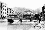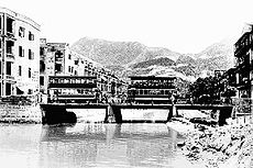
Canal Road, Hong Kong
Encyclopedia

Wan Chai
Wan Chai is a metropolitan area situated at the western part of the Wan Chai District on the northern shore of Hong Kong Island, in Hong Kong. Its other boundaries are Canal Road to the east, Arsenal Street to the west and Bowen Road to the south. The area north of Gloucester Road is often called...
and Causeway Bay
Causeway Bay
Causeway Bay is a heavily built-up area of Hong Kong, People's Republic of China, located on the Hong Kong Island, and covering parts of Wan Chai and Eastern districts. The Chinese name is also romanized as Tung Lo Wan as in Tung Lo Wan Road...
, Wan Chai District
Wan Chai District
The Wan Chai District is one of the 18 districts of Hong Kong, located in the north of Hong Kong island. It had a population of 167,146 in 2001. The district has the second most educated residents with the highest income, the second lowest population and the third oldest residents, and is also the...
of Hong Kong
Hong Kong
Hong Kong is one of two Special Administrative Regions of the People's Republic of China , the other being Macau. A city-state situated on China's south coast and enclosed by the Pearl River Delta and South China Sea, it is renowned for its expansive skyline and deep natural harbour...
.
Before urban development the area was the estuary of a river named "Wong Nai Chung", which looked like the neck of a goose. The 4th Governor of Hong Kong
Governor of Hong Kong
The Governor of Hong Kong was the head of the government of Hong Kong during British rule from 1843 to 1997. The governor's roles were defined in the Hong Kong Letters Patent and Royal Instructions...
, John Bowring
John Bowring
Sir John Bowring, KCB was an English political economist, traveller, miscellaneous writer, polyglot, and the 4th Governor of Hong Kong.- Early life :...
built Bowrington (or Bowring City) around the estuary. Bowrington Canal was built during the mid to late 1850s as the extension of Wong Nai Chung and the long and narrow canal
Canal
Canals are man-made channels for water. There are two types of canal:#Waterways: navigable transportation canals used for carrying ships and boats shipping goods and conveying people, further subdivided into two kinds:...
was known as and thus known as Ngo Keng Kan (鵝頸澗, lit. goose neck stream). The landmark Bowrington Bridge built in 1861 across the canal was known as Ngo Keng Kiu (鵝頸橋, lit. goose neck bridge). The area surrounding are also known as Ngo Keng. During the reclamation
Land reclamation in Hong Kong
Land is in short supply in Hong Kong, and land reclamation has been conducted there since the mid-19th century.-Projects:One of the earliest and famous project was the Praya Reclamation Scheme, which added 50 to of land in 1890 during the second phase of construction...
of Wan Chai
Wan Chai
Wan Chai is a metropolitan area situated at the western part of the Wan Chai District on the northern shore of Hong Kong Island, in Hong Kong. Its other boundaries are Canal Road to the east, Arsenal Street to the west and Bowen Road to the south. The area north of Gloucester Road is often called...
beside Victoria Harbour
Victoria Harbour
Victoria Harbour is a natural landform harbour situated between Hong Kong Island and the Kowloon Peninsula in Hong Kong. The harbour's deep, sheltered waters and strategic location on the South China Sea were instrumental in Hong Kong's establishment as a British colony and its subsequent...
from 1922 to 1929, the canal was covered and made subterranean and the bridge was removed. However the name survives in the history and remains the name of the area.
Canal Road Flyover
Canal Road Flyover was built in 1970s for the Cross-Harbour Tunnel, between Canal Road East and Canal Road West. Many who do not know the history of Canal Road might associate the flyoverOverpass
An overpass is a bridge, road, railway or similar structure that crosses over another road or railway...
with Ngo Keng Kiu. It initially connected only Canal Road West to the north of Gloucester Road when it opened on 29 March 1972. Four years later, the flyover was expanded and extended south to the Aberdeen Tunnel entrance in Happy Valley
Happy Valley, Hong Kong
Happy Valley is a mostly residential suburb of Hong Kong, located in the northern part of Hong Kong Island. Administratively, it is part of Wan Chai District....
in 1976. The flyover was expanded again and an exit connected to Canal Road East.
The flyover currently joins Aberdeen Tunnel
Aberdeen Tunnel
Aberdeen Tunnel is a two-tube tunnel linking Happy Valley and Wong Chuk Hang near Aberdeen on the Hong Kong Island, Hong Kong. It shortens the travel time between the north and the south of the Hong Kong Island. It connects the Wong Chuk Hang Road in the south, and Canal Road Flyover in the...
and Cross Harbour Tunnel thoroghfare Causeway Bay
Causeway Bay
Causeway Bay is a heavily built-up area of Hong Kong, People's Republic of China, located on the Hong Kong Island, and covering parts of Wan Chai and Eastern districts. The Chinese name is also romanized as Tung Lo Wan as in Tung Lo Wan Road...
in Wan Chai District
Wan Chai District
The Wan Chai District is one of the 18 districts of Hong Kong, located in the north of Hong Kong island. It had a population of 167,146 in 2001. The district has the second most educated residents with the highest income, the second lowest population and the third oldest residents, and is also the...
, Hong Kong Island
Hong Kong Island
Hong Kong Island is an island in the southern part of the Hong Kong Special Administrative Region. It has a population of 1,289,500 and its population density is 16,390/km², as of 2008...
, Hong Kong
Hong Kong
Hong Kong is one of two Special Administrative Regions of the People's Republic of China , the other being Macau. A city-state situated on China's south coast and enclosed by the Pearl River Delta and South China Sea, it is renowned for its expansive skyline and deep natural harbour...
. It is a very important bridge for travelling to the Southern District
Southern District, Hong Kong
The Southern District is one of the 18 districts of Hong Kong. It is located in the southern part of Hong Kong Island. It had a population of 290,240 in 2001. This district has the fourth lowest population of Hong Kong.-Geography:...
and Happy Valley. In order, it starts in the Wan Chai interchange, it passes-by Gloucester Road
Gloucester Road, Hong Kong
Gloucester Road is a major road in Hong Kong. It is in the north of Wan Chai and East Point on Hong Kong Island. It connects to Harcourt Road at its western end and it ends east along west side of Victoria Park. It forms part of Hong Kong's Route 4 and connects to the Island Eastern Corridor via...
, Jaffe Road
Jaffe Road
Jaffe Road is a long street in Hong Kong that runs between and parallel to Gloucester Road and Lockhart Road. At both the Wanchai and Causeway Bay ends of the street there are many bars and restaurants....
, Lockhart Road
Lockhart Road
Lockhart Road is a road spanning the whole length of Wan Chai from east to west on the Hong Kong Island of Hong Kong. It begins at Arsenal Street in the west and ends in East Point Road in East Point.- History :...
, Hennessy Road
Hennessy Road
Hennessy Road is a thoroughfare on Hong Kong Island, Hong Kong. It connects Yee Wo Street on the east in Causeway Bay, and Queensway on the western end in Wan Chai.The road is named after John Pope Hennessy, the Governor of Hong Kong between 1877 and 1882....
Times Square, Leighton Road
Leighton Road
Leighton Road is a main road in Causeway Bay and Wan Chai in Hong Kong. It begins east Causeway Road and ends west at the junction of Morrison Hill Road and Canal Road....
, Queen's Road
Queen's Road
Queen's Road is the first road in Hong Kong built by the Government of Hong Kong between 1841 and 1843, spanning across Victoria City from Shek Tong Tsui to Wan Chai...
East, Racing Museum and Wong Nai Chung Road
Wong Nai Chung Road
Wong Nai Chung Road is a major road in Happy Valley, Hong Kong. It is a U-shaped road that encircles the southern and eastern sides of the Happy Valley Racecourse. It starts northeast at the junction with Leighton Road, then turns southward and meets Blue Pool Road at the southern residential area...
.
Under the Canal Road Flyover, Villain hitting
Villain hitting
Villain hitting, Da Siu Yan or demon exorcising is a folk sorcery popular in the Guangdong area of China and Hong Kong. Its purpose is to curse one's enemies using magic...
activities are often seen especially in Jingzhe
Jingzhe
Jīngzhé or Keichitsu is the 3rd of 24 solar terms in the traditional East Asian calendars. It begins when the Sun reaches the celestial longitude of 345° and ends when it reaches the longitude of 360°. It more often refers in particular to the day when the Sun is exactly at the celestial...
, which has become a feature in Hong Kong culture.

