Canisp
Encyclopedia
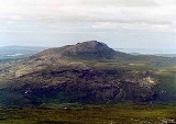
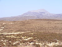
Canisp is a mountain in the far north west of Scotland
. It is situated in the parish of Assynt
, in the county of Sutherland
, 25 kilometres north of the town of Ullapool
. Canisp reaches a height of 847 metres (2779 feet) and qualifies as a Corbett and Marilyn
hill. The mountain's name translates from the Old Norse
language as “White Mountain”.
of 691 metres (2,280 feet) making the mountain a very good viewpoint. Canisp has very little vegetation. Even on its lower slopes large areas of Gneiss
(one of the oldest rocks in the world) are visible on the surface. Canisp is in the strange situation of being eclipsed by the nearby smaller mountain of Suilven
which stands five kilometres to the west and is 116 metres lower in altitude. Suilven is a more popular mountain with its jagged summit ridge. Canisp stands in a geologically important area. It is part of the Moine Thrust Belt
and is typical of many of the Assynt hills in that it rises from a base of Lewisian Gneiss
and is composed of Torridonian
sandstone
capped by Cambrian
quartzite
giving the hill a distinctive light grey crown. Its rocks show signs of major abrasions left by the scouring of the landscape by glaciation during the last ice age
.
Canisp stands on the lands of the Glencanisp and Drumrunie Estates, a 44,000 acre (176 km²) tract of land which was bought in 2005 for £2,900,000 by the Assynt Foundation, a group of around 900 local residents, from the Vestey family. Compared to the other Assynt hills, Canisp does not show any distinct topographic qualities. It is a fairly uncomplicated mountain with a symmetrical profile with two main ridges running northwest and southeast. Its southwestern flank has crags and scree
which falls steeply into Glen Canisp, while its northeastern slopes also fall precipitously to the lochan studded moorland
.
 The most popular ascent of Canisp starts at the north end of Loch Awe where there is car parking and a footbridge to cross the River Loanan as it leaves the loch. The route gains the summit by the south east ridge. This is the shortest and quickest route, but it is still 6 km long, almost completely devoid of paths, and defended by stones, heather and bog. Another ascent from the east which also uses the SE ridge starts at Stronchrubie where there is also a footbridge over the Loanan. Longer ascents are also possible from Lochinver
and Ledmore Junction, both these routes utilise the path between the two places that traverses the length of Glen Canisp before leaving the glen to climb the mountain by either its north west ridge (from Lochinver) or south east ridge (from Ledmore). The route from Lochinver gains the NW ridge by a path from Loch na Gainimh and is regarded by Hamish Brown
as the most pleasing way up the mountain. The summit of Canisp is marked by a large stone built wind shelter. The view from the top of the mountain is regarded as one of the finest in Scotland giving all round views taking in the surrounding loch studded moorland, The Minch
beyond Lochinver and most of the well known mountains of Assynt.
Scotland
Scotland is a country that is part of the United Kingdom. Occupying the northern third of the island of Great Britain, it shares a border with England to the south and is bounded by the North Sea to the east, the Atlantic Ocean to the north and west, and the North Channel and Irish Sea to the...
. It is situated in the parish of Assynt
Assynt
Assynt is a civil parish in west Sutherland, Highland, Scotland – north of Ullapool.It is famous for its landscape and its remarkable mountains...
, in the county of Sutherland
Sutherland
Sutherland is a registration county, lieutenancy area and historic administrative county of Scotland. It is now within the Highland local government area. In Gaelic the area is referred to according to its traditional areas: Dùthaich 'IcAoidh , Asainte , and Cataibh...
, 25 kilometres north of the town of Ullapool
Ullapool
Ullapool is a small town of around 1,300 inhabitants in Ross and Cromarty, Highland, Scotland. Despite its small size, it is the largest settlement for many miles around, and is a major tourist destination of Scotland. The North Atlantic Drift passes by Ullapool, bringing moderate temperatures...
. Canisp reaches a height of 847 metres (2779 feet) and qualifies as a Corbett and Marilyn
Marilyn (hill)
A Marilyn is a mountain or hill in the United Kingdom, Republic of Ireland or Isle of Man with a relative height of at least 150 metres , regardless of absolute height or other merit...
hill. The mountain's name translates from the Old Norse
Old Norse
Old Norse is a North Germanic language that was spoken by inhabitants of Scandinavia and inhabitants of their overseas settlements during the Viking Age, until about 1300....
language as “White Mountain”.
Geography and Geology
Canisp is an isolated mountain that stands in the Glencanisp Forest, a large rock and water wilderness. It has a considerable topographic prominenceTopographic prominence
In topography, prominence, also known as autonomous height, relative height, shoulder drop , or prime factor , categorizes the height of the mountain's or hill's summit by the elevation between it and the lowest contour line encircling it and no higher summit...
of 691 metres (2,280 feet) making the mountain a very good viewpoint. Canisp has very little vegetation. Even on its lower slopes large areas of Gneiss
Gneiss
Gneiss is a common and widely distributed type of rock formed by high-grade regional metamorphic processes from pre-existing formations that were originally either igneous or sedimentary rocks.-Etymology:...
(one of the oldest rocks in the world) are visible on the surface. Canisp is in the strange situation of being eclipsed by the nearby smaller mountain of Suilven
Suilven
Suilven is one of the most distinctive mountains in Scotland. Lying in a remote area in the west of Sutherland, it rises almost vertically from a wilderness landscape of moorland, bogs and lochans known as Inverpolly National Nature Reserve....
which stands five kilometres to the west and is 116 metres lower in altitude. Suilven is a more popular mountain with its jagged summit ridge. Canisp stands in a geologically important area. It is part of the Moine Thrust Belt
Moine Thrust Belt
The Moine Thrust Belt is a linear geological feature in the Scottish Highlands which runs from Loch Eriboll on the north coast 190 km south-west to the Sleat peninsula on the Isle of Skye...
and is typical of many of the Assynt hills in that it rises from a base of Lewisian Gneiss
Lewisian complex
The Lewisian complex or Lewisian Gneiss is a suite of Precambrian metamorphic rocks that outcrop in the northwestern part of Scotland, forming part of the Hebridean Terrane. These rocks are of Archaean and Paleoproterozoic age, ranging from 3.0–1.7 Ga. They form the basement on which the...
and is composed of Torridonian
Torridonian
In geology, Torridonian describes a series of Neoproterozoic arenaceous sedimentary rocks, extensively developed in the Northwest Highlands of Scotland, and particularly in the district of upper Loch Torridon, a circumstance which suggested the name Torridon Sandstone, first applied to these rocks...
sandstone
Sandstone
Sandstone is a sedimentary rock composed mainly of sand-sized minerals or rock grains.Most sandstone is composed of quartz and/or feldspar because these are the most common minerals in the Earth's crust. Like sand, sandstone may be any colour, but the most common colours are tan, brown, yellow,...
capped by Cambrian
Cambrian
The Cambrian is the first geological period of the Paleozoic Era, lasting from Mya ; it is succeeded by the Ordovician. Its subdivisions, and indeed its base, are somewhat in flux. The period was established by Adam Sedgwick, who named it after Cambria, the Latin name for Wales, where Britain's...
quartzite
Quartzite
Quartzite is a hard metamorphic rock which was originally sandstone. Sandstone is converted into quartzite through heating and pressure usually related to tectonic compression within orogenic belts. Pure quartzite is usually white to gray, though quartzites often occur in various shades of pink...
giving the hill a distinctive light grey crown. Its rocks show signs of major abrasions left by the scouring of the landscape by glaciation during the last ice age
Ice age
An ice age or, more precisely, glacial age, is a generic geological period of long-term reduction in the temperature of the Earth's surface and atmosphere, resulting in the presence or expansion of continental ice sheets, polar ice sheets and alpine glaciers...
.
Canisp stands on the lands of the Glencanisp and Drumrunie Estates, a 44,000 acre (176 km²) tract of land which was bought in 2005 for £2,900,000 by the Assynt Foundation, a group of around 900 local residents, from the Vestey family. Compared to the other Assynt hills, Canisp does not show any distinct topographic qualities. It is a fairly uncomplicated mountain with a symmetrical profile with two main ridges running northwest and southeast. Its southwestern flank has crags and scree
Scree
Scree, also called talus, is a term given to an accumulation of broken rock fragments at the base of crags, mountain cliffs, or valley shoulders. Landforms associated with these materials are sometimes called scree slopes or talus piles...
which falls steeply into Glen Canisp, while its northeastern slopes also fall precipitously to the lochan studded moorland
Moorland
Moorland or moor is a type of habitat, in the temperate grasslands, savannas, and shrublands biome, found in upland areas, characterised by low-growing vegetation on acidic soils and heavy fog...
.
Ascents

Lochinver
Lochinver is a village on the coast in the Assynt district of Sutherland, Highland, Scotland. A few miles northeast is Loch Assynt which is the source of the River Inver which flows into Loch Inver at the village. There are 200 or so lochans in the area which makes the place very popular with...
and Ledmore Junction, both these routes utilise the path between the two places that traverses the length of Glen Canisp before leaving the glen to climb the mountain by either its north west ridge (from Lochinver) or south east ridge (from Ledmore). The route from Lochinver gains the NW ridge by a path from Loch na Gainimh and is regarded by Hamish Brown
Hamish Brown
Hamish Brown M.B.E. is a professional writer, lecturer and photographer specialising in mountain and outdoor topics. He is best known for his walking exploits in the Scottish Highlands, having completed multiple rounds of the Munros and being the first person to walk all the Munros in a single trip...
as the most pleasing way up the mountain. The summit of Canisp is marked by a large stone built wind shelter. The view from the top of the mountain is regarded as one of the finest in Scotland giving all round views taking in the surrounding loch studded moorland, The Minch
The Minch
The Minch , also called The North Minch, is a strait in north-west Scotland, separating the north-west Highlands, and the northern Inner Hebrides, from Lewis and Harris in the Outer Hebrides...
beyond Lochinver and most of the well known mountains of Assynt.

