

Cape Dezhnev
Encyclopedia
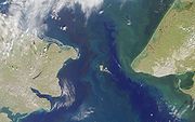
Cape Dezhnyov or Cape Dezhnev is a cape
that forms the eastmost mainland point of Eurasia
. It is located on the Chukchi Peninsula
in the very thinly populated Chukotka Autonomous Okrug
of Russia
. This cape is located between the Bering Sea
and the Chukchi Sea
, 82 kilometres (51 mi) across from Cape Prince of Wales
in Alaska
. The Bering Strait
lies in between and the Diomede Islands
and Fairway Rock
are located in the midst of the strait.
 The cape is the eastern tip of a high, rocky headland, about 20 kilometres (12.4 mi) from Uelen
in the north to Cape Pe'ek in the south, connected to the mainland by a neck of lower-lying land peppered with swamps and shallow lakes. That low-lying land is so low in elevation that the cape appears as an island from a distance far to the south of it. The US Hydrographic Office publication Asiatic Pilot from 1909 gives the height of the headland as 2521 feet (768.4 m), and the US Office of Coast Survey chart of 2000 shows the highest peak at 2638 feet (804.1 m). The headland
and the neck of low-lying land together form a peninsula
. In 1898, the cape was officially renamed as Cape Dezhnev, replacing Captain James Cook
's name, the "East Cape". It was named in honor of Semyon Dezhnyov, the first recorded European to round its tip (in 1648). There is a large monument to Dezhnev on the seacoast.
The Great Circle
distance from Cape Dezhnev to the shore of the Bab-el-Mandeb
strait in Yemen
is about 10,855 km, which is the longest land distance of Asia
.
Cape (geography)
In geography, a cape or headland is a point or body of land extending into a body of water, usually the sea.A cape usually represents a marked change in trend of the coastline. Their proximity to the coastline makes them prone to natural forms of erosion, mainly tidal actions. This results in capes...
that forms the eastmost mainland point of Eurasia
Eurasia
Eurasia is a continent or supercontinent comprising the traditional continents of Europe and Asia ; covering about 52,990,000 km2 or about 10.6% of the Earth's surface located primarily in the eastern and northern hemispheres...
. It is located on the Chukchi Peninsula
Chukchi Peninsula
The Chukchi Peninsula, Chukotka Peninsula or Chukotski Peninsula , at about 66° N 172° W, is the northeastern extremity of Asia. Its eastern end is at Cape Dezhnev near the village of Uelen. It is bordered by the Chukchi Sea to the north, the Bering Sea to the south, and the Bering Strait to the...
in the very thinly populated Chukotka Autonomous Okrug
Chukotka Autonomous Okrug
Chukotka Autonomous Okrug , or Chukotka , is a federal subject of Russia located in the Russian Far East.Chukotka has a population of 53,824 according to the 2002 Census, and a surface area of . The principal town and the administrative center is Anadyr...
of Russia
Russia
Russia or , officially known as both Russia and the Russian Federation , is a country in northern Eurasia. It is a federal semi-presidential republic, comprising 83 federal subjects...
. This cape is located between the Bering Sea
Bering Sea
The Bering Sea is a marginal sea of the Pacific Ocean. It comprises a deep water basin, which then rises through a narrow slope into the shallower water above the continental shelves....
and the Chukchi Sea
Chukchi Sea
Chukchi Sea is a marginal sea of the Arctic Ocean. It is bounded on the west by the De Long Strait, off Wrangel Island, and in the east by Point Barrow, Alaska, beyond which lies the Beaufort Sea. The Bering Strait forms its southernmost limit and connects it to the Bering Sea and the Pacific...
, 82 kilometres (51 mi) across from Cape Prince of Wales
Cape Prince of Wales
Cape Prince of Wales is the westernmost point on the mainland of the Americas.Located on the Seward Peninsula of the U.S. state of Alaska near the city of Wales, Cape Prince of Wales is the terminus of the Continental Divide, marking the division between the Pacific and Arctic coasts, as well as...
in Alaska
Alaska
Alaska is the largest state in the United States by area. It is situated in the northwest extremity of the North American continent, with Canada to the east, the Arctic Ocean to the north, and the Pacific Ocean to the west and south, with Russia further west across the Bering Strait...
. The Bering Strait
Bering Strait
The Bering Strait , known to natives as Imakpik, is a sea strait between Cape Dezhnev, Chukotka Autonomous Okrug, Russia, the easternmost point of the Asian continent and Cape Prince of Wales, Alaska, USA, the westernmost point of the North American continent, with latitude of about 65°40'N,...
lies in between and the Diomede Islands
Diomede Islands
The Diomede Islands , also known in Russia as Gvozdev Islands , consist of two rocky, tuya-like islands:* The U.S. island of Little Diomede or, in its native language, Ignaluk , and* The Russian island of Big Diomede , also known as Imaqliq,...
and Fairway Rock
Fairway Rock
Fairway Rock is a small islet in the Bering Strait, located southeast of the Diomede Islands and west of Alaska's Cape Prince of Wales. It has an area of 0.3 km² . Known to Eskimo natives of the Bering Strait region in prehistory, Fairway was documented by James Cook in 1778 and named by...
are located in the midst of the strait.
Geography
Uelen
Uelen is a rural locality in the Chukotsky District, just south of the Arctic Circle in Chukotka Autonomous Okrug in the Russian Far East. Population: 776 in 2003, with 595 Chukchi and 72 Yupik. Located near Cape Dezhnev where the Bering Sea meets the Chukchi Sea, it is the easternmost settlement...
in the north to Cape Pe'ek in the south, connected to the mainland by a neck of lower-lying land peppered with swamps and shallow lakes. That low-lying land is so low in elevation that the cape appears as an island from a distance far to the south of it. The US Hydrographic Office publication Asiatic Pilot from 1909 gives the height of the headland as 2521 feet (768.4 m), and the US Office of Coast Survey chart of 2000 shows the highest peak at 2638 feet (804.1 m). The headland
Headland
A headland is a point of land, usually high and often with a sheer drop, that extends out into a body of water.Headland can also refer to:*Headlands and bays*headLand, an Australian television series...
and the neck of low-lying land together form a peninsula
Peninsula
A peninsula is a piece of land that is bordered by water on three sides but connected to mainland. In many Germanic and Celtic languages and also in Baltic, Slavic and Hungarian, peninsulas are called "half-islands"....
. In 1898, the cape was officially renamed as Cape Dezhnev, replacing Captain James Cook
James Cook
Captain James Cook, FRS, RN was a British explorer, navigator and cartographer who ultimately rose to the rank of captain in the Royal Navy...
's name, the "East Cape". It was named in honor of Semyon Dezhnyov, the first recorded European to round its tip (in 1648). There is a large monument to Dezhnev on the seacoast.
The Great Circle
Great circle
A great circle, also known as a Riemannian circle, of a sphere is the intersection of the sphere and a plane which passes through the center point of the sphere, as opposed to a general circle of a sphere where the plane is not required to pass through the center...
distance from Cape Dezhnev to the shore of the Bab-el-Mandeb
Bab-el-Mandeb
The Bab-el-Mandeb meaning "Gate of Grief" in Arabic , is a strait located between Yemen on the Arabian Peninsula, Djibouti and Eritrea, north of Somalia, in the Horn of Africa, and connecting the Red Sea to the Gulf of Aden...
strait in Yemen
Yemen
The Republic of Yemen , commonly known as Yemen , is a country located in the Middle East, occupying the southwestern to southern end of the Arabian Peninsula. It is bordered by Saudi Arabia to the north, the Red Sea to the west, and Oman to the east....
is about 10,855 km, which is the longest land distance of Asia
Asia
Asia is the world's largest and most populous continent, located primarily in the eastern and northern hemispheres. It covers 8.7% of the Earth's total surface area and with approximately 3.879 billion people, it hosts 60% of the world's current human population...
.