

Caraguatatuba (micro-region)
Encyclopedia
Microregion (Brazil)
Microregions are legally defined administrative areas in Brazil consisting of groups of municipalities bordering urban areas. Microregions are grouped together into mesoregions....
in the easternmost coastal part of São Paulo State
São Paulo (state)
São Paulo is a state in Brazil. It is the major industrial and economic powerhouse of the Brazilian economy. Named after Saint Paul, São Paulo has the largest population, industrial complex, and economic production in the country. It is the richest state in Brazil...
, Brazil
Brazil
Brazil , officially the Federative Republic of Brazil , is the largest country in South America. It is the world's fifth largest country, both by geographical area and by population with over 192 million people...
, and comprises the cities of Caraguatatuba
Caraguatatuba
Caraguatatuba, widely known by its abbreviation Caraguá, is a city in the eastern part of the southern state of São Paulo in Brazil. The name comes from the Tupi language and one of the words includes tuba meaning many. Caraguatatuba is the largest city of São Paulo north shore.The economy of the...
, Ilhabela, São Sebastião
São Sebastião, São Paulo
São Sebastião is a Brazilian city, located on the southeast coast of Brazil, in the state of São Paulo. The population in 2006 is 75,886, its density is 188.1/km² and the area is 403 km². The Tropic of Capricorn lies 25 km north...
, Ubatuba. The microregion is bordered by the state of Rio de Janeiro
Rio de Janeiro (state)
Rio de Janeiro is one of the 27 states of Brazil.Rio de Janeiro has the second largest economy of Brazil behind only São Paulo state.The state of Rio de Janeiro is located within the Brazilian geopolitical region classified as the Southeast...
to the east. It is a famous touristic destination, mainly because of the 160 beaches. According to IBGE
IBGE
The Brazilian Institute of Geography and Statistics or IBGE , is the agency responsible for statistical, geographic, cartographic, geodetic and environmental information in Brazil...
, Caraguatatuba microregion has a GDP of R$2.019.943.048,00 and a population of 281.532 people spread over an area of 1.947,702 km², which means that the density is 144,5/km². The population main increase considerably during the summer, because of the tourists.
History
The first city to be settled was São Sebastião, in 1636. Ubatuba came next, in 1637, and then Ilhabela in 1805. Caraguatatuba was the last one, in 1857. However, it is important to note that the channel between Ilhabela and São Sebastião had already been sailed by the Portuguese in 1502.All four cities relied on agriculture and fishing as its main economic activities for most of the 17th, 18th and 19th centuries, whereas São Sebastião served as a major sugar cane, coffea
Coffea
Coffea is a genus of flowering plants in the Rubiaceae family. They are shrubs or small trees native to tropical and southern Africa and tropical Asia. Seeds of several species are the source of the popular beverage coffee. Coffee ranks as one of the world's most valuable and widely traded...
and tobacco
Tobacco
Tobacco is an agricultural product processed from the leaves of plants in the genus Nicotiana. It can be consumed, used as a pesticide and, in the form of nicotine tartrate, used in some medicines...
production site. In the second half of the 20th
century, the cities started to receive several tourists, mostly from São Paulo
São Paulo
São Paulo is the largest city in Brazil, the largest city in the southern hemisphere and South America, and the world's seventh largest city by population. The metropolis is anchor to the São Paulo metropolitan area, ranked as the second-most populous metropolitan area in the Americas and among...
and nearby cities. This made it possible for the region to make money out of tourism, via hotels, restaurants, handicraft stores and nightclubs.
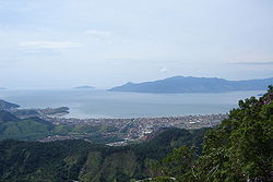
Geography
The Serra do MarSerra do Mar
Serra do Mar is a 1,500 km long system of mountain ranges and escarpments in Southeastern Brazil, which runs in parallel to the Atlantic Ocean coast from the state of Espírito Santo to southern Santa Catarina, although some include Serra Geral in the Serra do Mar, in which case this range...
mountain range dominates the landscape of the microregion. Urbanization took place in the plains between the mountains and the sea. The highest point is the Pico de São Sebastião (Saint Sebastian's Peak), in Ilhabela, at 1.378m above sea level. The Oceanic climate
Oceanic climate
An oceanic climate, also called marine west coast climate, maritime climate, Cascadian climate and British climate for Köppen climate classification Cfb and subtropical highland for Köppen Cfb or Cwb, is a type of climate typically found along the west coasts at the middle latitudes of some of the...
sets the temperatures around the region between 20º-30ºC for most of the year. Rain falls moderately, but it falls more frequently particularly in Ubatuba, which is the reason of the city's nickname Ubachuva (lit. Ubarain).
Highways
The only road crossing all the microregion (except for the non-continental municipality Ilhabela) is the BR-101BR-101
The BR-101 is a longitudinal highway of Brazil. It is the longest in the country with a length of nearly , and it is also considered the most important....
, which runs near the sea and serves as the main connection between the cities. São Sebastião is the only city not to have a connection to the countryside. Caraguatatuba is connected to São José dos Campos
São José dos Campos
São José dos Campos is a municipality and a major city in the state of São Paulo, Brazil and one of the most important industrial and research centers in Latin America. It is located in the Paraíba Valley, between the two most active production and consumption regions in the country, São Paulo ...
via the Rodovia dos Tamoios
Rodovia dos Tamoios
Rodovia dos Tamoios is a highway in the Brazilian state of São Paulo.The highway is partly dual-lane, part single-lane, and runs from the city of São José dos Campos, located in the Paraíba River valley in the upper plateau of São Paulo down the Serra do Mar to the coastal lowlands of the city of...
. From Ubatuba, it is possible to reach Taubaté
Taubaté
Taubaté is a city in the State of São Paulo, in southeastern Brazil. Its strategic geographical location, between the two most important Brazilian cities , being crossed by Presidente Dutra Highway which connects the two megacities, and between high, cold mountains and the Atlantic Ocean has...
via the Rodovia Oswaldo Cruz
Rodovia Oswaldo Cruz
Rodovia Oswaldo Cruz is a state highway in the state of São Paulo in Brazil....
.
As of Ilhabela, the island is only accessible via the ferry boats departing from São Sebastião. The crossing takes 15 minutes, although sometimes people must wait more than an hour to take the boat.