

Carrum Downs, Victoria
Encyclopedia
Melbourne
Melbourne is the capital and most populous city in the state of Victoria, and the second most populous city in Australia. The Melbourne City Centre is the hub of the greater metropolitan area and the Census statistical division—of which "Melbourne" is the common name. As of June 2009, the greater...
, Victoria
Victoria (Australia)
Victoria is the second most populous state in Australia. Geographically the smallest mainland state, Victoria is bordered by New South Wales, South Australia, and Tasmania on Boundary Islet to the north, west and south respectively....
, Australia
Australia
Australia , officially the Commonwealth of Australia, is a country in the Southern Hemisphere comprising the mainland of the Australian continent, the island of Tasmania, and numerous smaller islands in the Indian and Pacific Oceans. It is the world's sixth-largest country by total area...
, 34 km south-east from Melbourne's central business district
Melbourne city centre
Melbourne City Centre is an area of Melbourne in Victoria, Australia. It is not to be confused with the larger local government area of the City of Melbourne...
. Its Local Government Area is the City of Frankston
City of Frankston
The City of Frankston is a Local Government Area in Victoria, Australia, located in the southern suburbs of Melbourne. It has an area of 131 square kilometres and has a estimated population of 128,576 people....
. At the 2006 Census, Carrum Downs had a population of 17,213.
Prior to December 1994 the majority of Carrum Downs was within the City of Cranbourne
City of Cranbourne
The City of Cranbourne was a Local Government Area located about southeast of Melbourne, the state capital of Victoria, Australia. The City covered an area of , and existed from 1860 until 1994...
. However, after statewide local government reform, the suburb was moved to be part of a new, larger City of Frankston
City of Frankston
The City of Frankston is a Local Government Area in Victoria, Australia, located in the southern suburbs of Melbourne. It has an area of 131 square kilometres and has a estimated population of 128,576 people....
In late 2006, RealEstatesource compiled a list of the top ten performing suburbs in Melbourne, Carrum Downs was ranked fourth with property showing a 94.4% median value increase since the real estate market's 'peak' of 2001.http://209.85.141.104/search?q=cache:U7FYXwkvZawJ:www.realestatesource.com.au/Articles/Top-Performing-Suburbs-Since-the-2001-Real-Estate-Peak.html+carru In January 2008, the 'Your Investment Property' periodical published an article on Carrum Downs, predicting an increased demand for residential and commercial property in the area, following the completion of the Eastlink project in June 2008.
Karrum Karrum
Before European settlers arrived at Port PhillipPort Phillip
Port Phillip Port Phillip Port Phillip (also commonly referred to as Port Phillip Bay or (locally) just The Bay, is a large bay in southern Victoria, Australia; it is the location of Melbourne. Geographically, the bay covers and the shore stretches roughly . Although it is extremely shallow for...
, Aborigines
Indigenous Australians
Indigenous Australians are the original inhabitants of the Australian continent and nearby islands. The Aboriginal Indigenous Australians migrated from the Indian continent around 75,000 to 100,000 years ago....
resting after the stiff climb of Oliver's Hill, Frankston
Frankston, Victoria
Frankston is a suburb within the Greater Melbourne metropolitan area in Victoria, Australia. It is located 40 km southeast of the state capital Melbourne at the southernmost edge of Greater Melbourne, near the beginnings of the Mornington Peninsula...
, and looking north along the bay would have viewed a long ribbon of sandy beach shaped vaguely like a boomerang. The area was called Karrum Karrum, or as some of the early squatters interpreted it, Garem Gam, meaning "Boomerang". The swampy marshland behind the sand dunes was a rich hunting ground teeming with wildlife.http://localhistory.kingston.vic.gov.au/htm/article/191.htm
Carrum Swamp
The Carrum Swamp measured approximately 15 km from north to south, and averaged about 5 km across from east to west. It was up to 8 km wide at the northern end. The high lands visible in the swamp were the Isles of Wannarkladdin, now Chelsea HeightsChelsea Heights, Victoria
Chelsea Heights is a suburb in Melbourne, Victoria, Australia, 30 km south-east from Melbourne's central business district. Its Local Government Area is the City of Kingston...
. The swampland with its dense growth of swamp tea-tree and other vegetation was covered for the most part by the waters from the Dandenong
Dandenong, Victoria
Dandenong is a suburb and major urban centre in metropolitan Melbourne, Victoria, Australia, 30 km south-east from Melbourne's central business district. Situated on Dandenong Creek and mostly flat land at the foothills of Mount Dandenong, it is the main administrative centre for the City of...
, Eumemmerring
Eumemmerring, Victoria
This article is about the suburb of Eumemmerring. For the Secondary College, see Eumemmerring College.Eumemmerring is a suburb in Melbourne, Victoria, Australia, 33 km south-east from Melbourne's central business district. Its Local Government Area is the City of Casey...
, and other smaller creeks, with a total catchment area of approximately 430 km², with the present townships of Langwarrin
Langwarrin, Victoria
Langwarrin is a suburb in Melbourne, Victoria, Australia, 43 km south-east from Melbourne's central business district. Its Local Government Area is the City of Frankston...
, Cranbourne
Cranbourne, Victoria
Cranbourne is a suburb in Melbourne, Victoria, Australia, 43 km south-east from Melbourne's central business district. Its Local Government Area is the City of Casey. At the 2006 Census, Cranbourne had a population of 14,750....
, Berwick
Berwick, Victoria
Berwick is a suburb in Melbourne, Victoria, Australia, south-east from Melbourne's central business district. Its Local Government Area is the City of Casey. At the 2006 Census, Berwick had a population of 36,420....
, Belgrave
Belgrave, Victoria
Belgrave is a suburb in Melbourne, Victoria, Australia, 35 km east from Melbourne's central business district. Its Local Government Area is the Shire of Yarra Ranges. At the 2006 Census, Belgrave had a population of 4094...
, Ferntree Gully
Ferntree Gully, Victoria
Ferntree Gully is a suburb in Melbourne, Victoria, Australia, in the Dandenong Ranges, 29 km east from Melbourne's central business district. It is in the Local Government Area's of the Shire of Yarra Ranges and the City of Knox...
, Olinda
Olinda, Victoria
Olinda is a suburb in Melbourne, Victoria, Australia, 36 km east from Melbourne's central business district. Its Local Government Area is the Shire of Yarra Ranges. At the 2006 Census, Olinda had a population of 1568.-History:...
, Lilydale
Lilydale, Victoria
Lilydale is a suburb of Melbourne, Victoria, Australia, 35 km north-east from Melbourne's central business district situated in the Olinda Creek valley. At the 2006 Census, Lilydale had a population of 13,887...
, Croydon
Croydon, Victoria
Croydon is a suburb in Melbourne, Victoria, Australia, 27 km east from Melbourne's central business district. Its Local Government Area is the City of Maroondah. At the 2006 Census, Croydon had a population of 22,029.-Public transport:...
and Ringwood
Ringwood, Victoria
Ringwood is a suburb in Melbourne, Victoria, Australia, east of Melbourne's central business district. Its Local Government Area is the City of Maroondah. At the 2006 Census, Ringwood had a population of 15,185....
forming its perimeter. Some of the waters eventually flowed through marshy country to the Mordialloc Creek or through to the Kananook Creek which flowed into the bay at Frankston.http://localhistory.kingston.vic.gov.au/htm/article/191.htm http://72.14.253.104/search?q=cache:rMvb4NwbmnUJ:www.arts.monash.edu.au/ncas/multimedia/gazetteer/list/carrumswmp.html+history+of+carrum+downs&hl=en&gl=au&ct=clnk&cd=313
The Carrum Swamp together with the larger Koo-Wee-Rup Swamp made a formidable barrier against the early explorers and land seekers in the early days.
The birth of Carrum - allotments on the Long Beach
The first survey of the Carrum swamp was made by T. E. Rawlinson, and completed by 2 January 1866. The only sign of European habitation reported by Rawlinson was a fisherman's cottage occupied by John Watkins and his family near the present Watkins Grove, AspendaleAspendale, Victoria
Aspendale is a suburb in Melbourne, Victoria, Australia, 27 km south-east from Melbourne's central business district. Its Local Government Area is the City of Kingston...
. The survey between the swamp and the sea resulted in Mr Callinan, the State’s assistant surveyor, dividing the area into 18 allotments stretching from the Mordialloc Creek to the present Keast Park, Seaford
Seaford, Victoria
Seaford is a suburb in Melbourne, Victoria, Australia, 36 km south-east from Melbourne's central business district. Its Local Government Area is the City of Frankston...
. The land was referred to as the "Allotments on the Long Beach", the first sales taking place at Semmell McCaul & Co’s Auction Rooms at Collins Street, Melbourne, on 22 December 1865. The upset price was $6 per acre
Acre
The acre is a unit of area in a number of different systems, including the imperial and U.S. customary systems. The most commonly used acres today are the international acre and, in the United States, the survey acre. The most common use of the acre is to measure tracts of land.The acre is related...
. Most of the land sold went to investors, but some development did take place near the already established fishing village of Mordialloc
Mordialloc, Victoria
Mordialloc is a suburb in Melbourne, Victoria, Australia, 24 km south-east from Melbourne's central business district. Its Local Government Area is the City of Kingston...
. Carrum Downs Post Office finally opened on 1 November 1909.
The land sold on the swamp side was bought by Hugh Brown who built his home "Pine Vale" near the site of the Mordialloc High School
Mordialloc Secondary College
Mordialloc Secondary College or Mordialloc College is a state co-educational secondary school located in the suburbs of Melbourne at Aspendale, City of Kingston, on the south bank of the Mordialloc Creek....
which was part of his property. He was 40 years a Councillor of the Shire of Dandenong
City of Greater Dandenong
The City of Greater Dandenong is a Local Government Area in Victoria, Australia located in the southeastern suburbs of Melbourne. It has an area of 130 square kilometres and has a estimated population of 137,600 people....
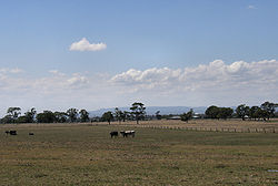
and served as President of the Shire. He was famous for his "Carrum" potatoes which were sent to several States. When Hugh Brown started farming there were still wild cattle roaming the swamplands from the original squatting days of the later 1830s to the 1850s. http://localhistory.kingston.vic.gov.au/htm/article/191.htm
The first settlement
During the Great DepressionGreat Depression
The Great Depression was a severe worldwide economic depression in the decade preceding World War II. The timing of the Great Depression varied across nations, but in most countries it started in about 1929 and lasted until the late 1930s or early 1940s...
, the Brotherhood of St Laurence
Brotherhood of St Laurence
The Brotherhood of St Laurence is an Australian not-for-profit organisation. Based in Melbourne, the Brotherhood has a national profile. The organisation's vision is for an Australia free of poverty. In working towards this vision it undertakes research and develops and delivers services and...
built a settlement at Carrum Downs to provide food and shelter to suffering families. After World War II
World War II
World War II, or the Second World War , was a global conflict lasting from 1939 to 1945, involving most of the world's nations—including all of the great powers—eventually forming two opposing military alliances: the Allies and the Axis...
, the suburb was gradually redeveloped as a Village for aged persons.http://www.bsl.org.au/main.asp?PageId=36
Botany Park and the redevelopment of Botany Bush
A small section of Carrum Downs is sometimes referred to by locals as "Botany Park", based on the name of a housing estate built during the late 1970s and early 1980s. In the first major developmentReal estate development
Real estate development, or Property Development, is a multifaceted business, encompassing activities that range from the renovation and re-lease of existing buildings to the purchase of raw land and the sale of improved land or parcels to others...
of its type in the area, land was subdivided into generous lots between the southern and northern perimeters of Ballarto and Hall Roads. The generous land allottments, affordability and proximity to Frankston
Frankston, Victoria
Frankston is a suburb within the Greater Melbourne metropolitan area in Victoria, Australia. It is located 40 km southeast of the state capital Melbourne at the southernmost edge of Greater Melbourne, near the beginnings of the Mornington Peninsula...
attracted families to the suburb. Development was conducted by AV Jennings, which financed and built prominent signage reading 'Botany Park' on the corner of Ballarto Road and Lyrebird Drive. The signage remains, although weather degradation and graffiti have degraded its appearance. During the early 1990s, the South Western quarter between Ballarto and Frankston-Dandenong Roads was known as 'Botany Bush'. The area was redeveloped into housing during the late 1990s.
Architecture
The suburb is a mixture of modern low scale dwellings with generous garden frontage and low scale fencing. During the 1990s, a large catchment of land remained as public park space, although this has subsequently been developed into housing. Housing construction continues in the suburb.Retail areas
Seaford, Victoria
Seaford is a suburb in Melbourne, Victoria, Australia, 36 km south-east from Melbourne's central business district. Its Local Government Area is the City of Frankston...
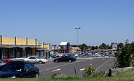
. The Carrum Downs Regional Shopping Centre is located on Hall Road in the centre of the suburb and is home to two banks, a Woolworths Supermarket and an independent supermarket, a Post Office, chemist
Chemist
A chemist is a scientist trained in the study of chemistry. Chemists study the composition of matter and its properties such as density and acidity. Chemists carefully describe the properties they study in terms of quantities, with detail on the level of molecules and their component atoms...
, newsagency
Newsagency
Newsagency can mean:*News agency, an organization of journalists established to supply news reports to organizations in the news trade.*The Australian English term for a newsagent's shop or news stand....
plus 40 other shops including liquor shops, clothing stores, fast food outlets, restaurants and real estate agents.
The Local Village @ Carrum Downs is located on the Dandenong-Frankston Road and comprises approximately 12 shops including an IGA
IGA (Australian supermarket group)
Independent Grocers of Australia, or IGA, is a chain of independent supermarkets in Australia. It is the local variant of the international Independent Grocers Association...
supermarket, cafe, bakery, newsagency, salon and pharmacy. Directly opposite the precinct is another small retail / business park.
The third shopping precinct which opened in 2008 and remains partially vacant, is located on the corner of McCormicks Road and Ballarto Road in the south of the suburb and includes 22 specialty shops as well as a Coles supermarket
Coles Supermarkets
Coles Supermarkets is an Australian supermarket chain owned by Wesfarmers. It has 741 stores nationally Coles Supermarkets is an Australian supermarket chain owned by Wesfarmers. It has 741 stores nationally Coles Supermarkets is an Australian supermarket chain owned by Wesfarmers. It has 741...
.
Schools
- There are four preschools in Carrum Downs at Botany Park, Bowerbird, Rowellyn and William Road.
- Primary school education is provided at Carrum Downs Primary, Rowellyn Park Primary, Skye, St Joachim's primary (a catholic faith school) and Flinders Christian College (a non-denominational Christian school).
- Secondary education is provided at Carrum Downs Secondary CollegeCarrum Downs Secondary CollegeCarrum Downs Secondary College is a public high school located in the Melbourne suburb of Carrum Downs in Victoria, Australia.Established in 2004, Carrum Downs Secondary has an enrolment of approximately 1,500 students....
http://www.cdsc.vic.edu.au (a government school) and at Flinders Christian College (a non-denominational Christian school). - Tertiary level training can be undertaken at the Monash University Peninsula campus, Institute of TAFE in nearby FrankstonFrankston, VictoriaFrankston is a suburb within the Greater Melbourne metropolitan area in Victoria, Australia. It is located 40 km southeast of the state capital Melbourne at the southernmost edge of Greater Melbourne, near the beginnings of the Mornington Peninsula...
.
Health Services
Carrum Downs is serviced by three medical centres, two dental clinics, two pharmacies and a physiotherapy clinic. Hospital facilities are provided at nearby FrankstonFrankston, Victoria
Frankston is a suburb within the Greater Melbourne metropolitan area in Victoria, Australia. It is located 40 km southeast of the state capital Melbourne at the southernmost edge of Greater Melbourne, near the beginnings of the Mornington Peninsula...
, about 10 minutes away.
Transportation
- Rail: Carrum Downs has no direct access to rail services. The closest rail links are the Kananook and SeafordSeaford railway station, MelbourneSeaford is a railway station in Melbourne, Victoria, Australia, located in the suburb of Seaford, on the Frankston railway line. Seaford is unmanned and is in Metcard Zone 2.-Facilities:...
stations on the Frankston line, both approximately 12 minutes (by car) from the centre of Carrum Downs, or the Merinda Park and Cranbourne stations on the Cranbourne line, both approximately 16 minutes away.
- Bus: Carrum Downs is serviced by two local bus routes.
- Road: Carrum Downs provides easy access to two major arterial roads. To the East of Carrum Downs, the Western Port Highway provides connectivity to Melbourne City in the north (via the South Gippsland FreewaySouth Gippsland FreewaySouth Gippsland Freeway is a short freeway linking Dandenong in Melbourne's south-east to other south-eastern destinations, including the Mornington Peninsula and the Gippsland region...
and the Monash FreewayMonash FreewayMonash Freeway is an urban freeway in Victoria, Australia linking Melbourne's CBD to its southeastern suburbs and the Gippsland region. The entire stretch of the Monash Freeway bears the designation...
). In a southerly direction, the Western Port Highway leads to the Port of HastingsHastings, VictoriaHastings is a suburb on the Mornington Peninsula, Victoria, Australia, as a part of the urban enclave on Westernport comprising Hastings, Bittern, Crib Point, Tyabb, and Somerville. Its Local Government Area is the Shire of Mornington Peninsula...
. To the West of Carrum Downs is the Nepean HighwayNepean HighwayNepean Highway runs south from the centre of Melbourne in Victoria, Australia to Portsea, along the eastern shore of Port Phillip. It is the primary road route to central Melbourne from Melbourne's southern suburbs.- History :...
, which runs south from Melbourne city to PortseaPortsea, VictoriaPortsea is a resort town located across Port Phillip from Melbourne, Victoria, Australia. Its Local Government Area is the Shire of Mornington Peninsula....
on the Mornington PeninsulaMornington PeninsulaThe Mornington Peninsula is a peninsula located south-east of Melbourne in Victoria, Australia. It is surrounded by Port Phillip to the west, Western Port to the east and Bass Strait to the south, and is connected to the mainland in the north. Geographically, the peninsula begins its protrusion...
, along the eastern shores of Port Phillip Bay. Also to the west is the Frankston FreewayFrankston FreewayFrankston Freeway is a very short stretch of Melbourne freeway that was designed to upgrade Wells Road to freeway standard in the 1970s and provides a link from suburban Melbourne to Frankston...
, which travels from Chelsea HeightsChelsea Heights, VictoriaChelsea Heights is a suburb in Melbourne, Victoria, Australia, 30 km south-east from Melbourne's central business district. Its Local Government Area is the City of Kingston...
in the north to the Mornington Peninsula in the south. Carrum Downs is also close to the Eastlink Tollway, which opened on June 29 2008. This runs from Rutherford Road in Carrum Downs (with travel further south provided by the Frankston Freeway) to DonvaleDonvale, VictoriaDonvale is a suburb in Melbourne, Victoria, Australia, 20 km east from Melbourne's central business district. Its Local Government Area is the City of Manningham. At the 2006 Census, Donvale had a population of 11,667...
in Melbourne's north east. Eastlink connects with the Monash Freeway and should reduce travelling time and distance to the City of Melbourne. Development of EastLink has led to strong commercial and industrial growth in Carrum Downs alongside the route of the EastLink. When completed, Peninsula Link will provide a freeway from the Eastlink/Frankston Freeway interchange, through Carrum Downs and then south to link with the Mornington Peninsula Freeway at Mount Martha.
Community Services
- The Lyrebird Community Centre is located in Carrum Downs. The Carrum Downs Community Centre was established in 1988 and was located in the GK Tucker Village as part of the Brotherhood of St Laurence. The centre consisted of two small cottages: one for child minding activities and the other housing the Centre Manager. In 1994, the Centre amalgamated to become the Lyrebird Community Centre and moved to its current location in Lyrebird Drive. During 2003, the Centre was renovated into a large modern complex. http://www.lyrebird.org.au/
- Carrum Downs offers Library Services via the Carrum Downs Library. http://www.frankston.vic.gov.au/Contact_Us/Service_Outlets/Carrum_Downs_Library/index.aspx
- A local branch of the Salvation ArmySalvation ArmyThe Salvation Army is a Protestant Christian church known for its thrift stores and charity work. It is an international movement that currently works in over a hundred countries....
operates within Carrum Downs. http://www.salvationarmy.org.au/carrumdowns/ - The 1st Carrum Downs Scout Group are based at the Recreation Reserve and run Cub Scouts, Joey Scouts, Scouts and Venturers.
- The Rotary Club of Seaford-Carrum Downs meets Tuesdays, 7.00pm, at The Sands Hotel, cnr Hall Road and Cadles Road, Carrum Downs.
Parks and Reserves
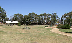
- Banyan Reserve, which includes a sports oval and a children's playground.
- Rotary Park, which includes barbecueBarbecueBarbecue or barbeque , used chiefly in the United States, Canada, the United Kingdom, New Zealand and Australia is a method and apparatus for cooking meat, poultry and occasionally fish with the heat and hot smoke of a fire, smoking wood, or hot coals of...
facilities and a children's playground. - Sandfield Reserve, which includes a children's playground, and skate park facilities.
In addition, there are several other wooded reserve areas which the public are allowed to walk through, and many of the housing developments feature public grassed areas and children's play facilities.
Sport and Fitness
- FootballAustralian rules footballAustralian rules football, officially known as Australian football, also called football, Aussie rules or footy is a sport played between two teams of 22 players on either...
: The Skye Bombers play their home games at the Recreation Reserve on Wedge Road. - Angling: The Sands Angling Club have their headquarters at the Recreation Reserve.
- Auskick: (A modified version of football for 5 - 12 year olds) The Rowellyn Park/Carrum Downs Auskick team plays its games at Banyan Reserve.
- Baseball: The Carrum Downs Baseball Club has junior and senior teams and plays its games at the Botany Park Reserve on Lyrebird Drive.
- Clay Target: The Frankston Clay Target Shooting Club is located on Rossiter Road in Carrum Downs, as is the Victorian Field & Game Association.
- Cricket: The Carrum Downs cricket club is based at the Recreation Reserve on Wedge Road.
- Driving: A variety of driving training courses (including defensive driving and motorcycle training) are held at DECA training on Thompson Road.
- Gymnasium: There are two fitness centres in Carrum Downs, located on Frankston-Dandenong Rd and a ladies only fitness centre located on Hall Rd.
- Paintball: Paintball Carrum Downs is located on Highview Road and features a 50 acres (202,343 m²) paintball field.
- Soccer: Carrum United Soccer Club is currently located outside the area. The Junior team plays at neighbouring Skye at the Recreation Reserve. The Senior team plays at the Italo Australian Club on Frankston-Dandenong Road, Dandenong.
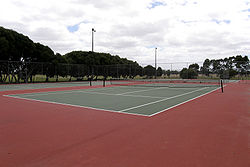
- Tennis: Facilities are available at the Carrum Downs Tennis Club at the Recreation Reserve on Wedge Road. There are four acrylic hard courts which replaced the two synthetic grass courts and two asphalt courts in 2006.
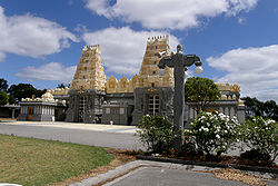
Shri Shiva Vishnu Temple
Trivia
- In March 2002, a famous, if unsubstantiated, UFO sighting occurred as a driver was passing through Carrum Downs. http://www.wunderkabinett.co.uk/damndata/index.php?/archives/308-Unidentified-Flying-Cubes.html
- Carrum Downs is home to Victorian PaintballPaintballPaintball is a sport in which players compete, in teams or individually, to eliminate opponents by tagging them with capsules containing water soluble dye and gelatin shell outside propelled from a device called a paintball marker . Paintballs have a non-toxic, biodegradable, water soluble...
Games, a 50 acres (202,343 m²) outdoor PaintballPaintballPaintball is a sport in which players compete, in teams or individually, to eliminate opponents by tagging them with capsules containing water soluble dye and gelatin shell outside propelled from a device called a paintball marker . Paintballs have a non-toxic, biodegradable, water soluble...
venue, their website is http://www.victorianpaintball.com.au.
See also
- City of SpringvaleCity of SpringvaleThe City of Springvale was a Local Government Area located about southeast of Melbourne, the state capital of Victoria, Australia. The city covered an area of , and existed from 1857 until 1994.-History:...
- the former local government area of which a small part of Carrum Downs was a part. - City of CranbourneCity of CranbourneThe City of Cranbourne was a Local Government Area located about southeast of Melbourne, the state capital of Victoria, Australia. The City covered an area of , and existed from 1860 until 1994...
- the former local government area of which most of Carrum Downs was a part.