Central Coast, Tasmania
Encyclopedia
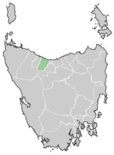
The Central Coast Council is a Local Government Area of Tasmania
, Australia
. It is located on the north-west coast of the state, between the cities of Devonport
and Burnie
.
The municipality contains two major centres Ulverstone
(population 10,424) and Penguin
(population 4,040), smaller towns include Forth
, and Turners Beach
. It has an estimated population of 21,747.
The Central Coast includes the tourist destination
s Leven Canyon
and Black Bluff, as well as a number of rural areas such as Upper Castra
.
The Central Coast Council was created on 2 April 1993, and covers an area of 932 square kilometre. The municipal boundaries are the Blythe River in the west, Braddons Lookout Road in the east and Black Bluff in the south.
TFR
for Central Coast Council was estimated at 1.92 in 2001 and 2.28 in 2006. Source
Tasmania
Tasmania is an Australian island and state. It is south of the continent, separated by Bass Strait. The state includes the island of Tasmania—the 26th largest island in the world—and the surrounding islands. The state has a population of 507,626 , of whom almost half reside in the greater Hobart...
, Australia
Australia
Australia , officially the Commonwealth of Australia, is a country in the Southern Hemisphere comprising the mainland of the Australian continent, the island of Tasmania, and numerous smaller islands in the Indian and Pacific Oceans. It is the world's sixth-largest country by total area...
. It is located on the north-west coast of the state, between the cities of Devonport
Devonport, Tasmania
-Sport:The Devonport Football Club is an Australian Rules team competing in the Tasmanian Statewide League. The Devonport Rugby Club is a Rugby Union team competing in the Tasmanian Rugby Union Statewide League...
and Burnie
Burnie, Tasmania
- Sport :Australian rules football is popular in Burnie. The city's team is the Burnie Dockers Football Club in the Tasmanian State League.Rugby union is also played in Burnie. The local club is the Burnie Rugby Union Club. They are the current Tasmanian Rugby Union Statewide Division Two Premiers...
.
The municipality contains two major centres Ulverstone
Ulverstone, Tasmania
Ulverstone is a town on the northwest coast of Tasmania, Australia. It lies at the mouth of the Leven River, on Bass Strait. It is on the Bass Highway, west of Devonport and east of Penguin....
(population 10,424) and Penguin
Penguin, Tasmania
Penguin is a town in the north-west coast of Tasmania, Australia. It is located in the Central Coast Council Local Government Area on the Bass Highway, between Burnie and Ulverstone. At the 2006 census, Penguin had a population of 2,943....
(population 4,040), smaller towns include Forth
Forth, Tasmania
Forth is a small village located in northwest Tasmania on the Forth River, west of Devonport and northwest of Launceston via the Bass Highway. Forth has a population of about 368...
, and Turners Beach
Turners Beach, Tasmania
Turners Beach is a small town on the north coast of Tasmania. Almost equidistant between the cities of Devonport and Ulverstone, it is located at the western mouth into Bass Strait of the Forth River, opposite the village of Leith located on its eastern mouth. Its population as at 2006 was 1 477...
. It has an estimated population of 21,747.
The Central Coast includes the tourist destination
Tourist destination
A tourist destination is a city, town, or other area that is dependent to a significant extent on the revenues accruing from tourism. It may contain one or more tourist attractions and possibly some "tourist traps."...
s Leven Canyon
Leven Canyon
Leven Canyon is a tourist destination on the Leven River, Tasmania. It is located from Ulverstone. The river runs through limestone cliffs carved through the Loongana Range, down to Bass Strait.-Tourism:...
and Black Bluff, as well as a number of rural areas such as Upper Castra
Upper Castra
Upper Castra is a small village outside Ulverstone in Tasmania. It is located in the Central Coast Council municipal area.-Etymology:The word castra is meant as "camp" in this context, and Upper Castra is so named because it is further inland from Castra....
.
The Central Coast Council was created on 2 April 1993, and covers an area of 932 square kilometre. The municipal boundaries are the Blythe River in the west, Braddons Lookout Road in the east and Black Bluff in the south.
TFR
Total Fertility Rate
The total fertility rate of a population is the average number of children that would be born to a woman over her lifetime if she were to experience the exact current age-specific fertility rates through her lifetime, and she...
for Central Coast Council was estimated at 1.92 in 2001 and 2.28 in 2006. Source

