Central Cross-Island Highway
Encyclopedia

Taiwan
Taiwan , also known, especially in the past, as Formosa , is the largest island of the same-named island group of East Asia in the western Pacific Ocean and located off the southeastern coast of mainland China. The island forms over 99% of the current territory of the Republic of China following...
.
Construction
The construction of the Central Cross-Island Highway began on July 7, 1956. And it was first opened to traffic on May 9, 1960.Route
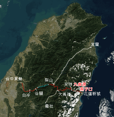
The route of the highway begins in the west at Dongshi District in TaichungTaichung
-Demographics:Taichung’s population was an estimated 1,040,725 in August 2006. There are slightly more females in the city than males.24.32% of residents are children, while 16.63% are young people, 52.68% are middle-age, and 6.73% are elderly....
. The highway originally continued up into the Central Mountain Range
Central Mountain Range
The Central Mountain Range, also known as the Chungyang Range , is the principal range of mountains in Taiwan. It runs from the north of the island to the south.Due to this separation, connecting between the west and east is not so convenient...
following the Dajia River (大甲溪) valley through the townships of Guguan
Guguan
Guguan is an island in the Northern Marianas island chain and is 130 miles north of Saipan. It measures only 3.87 km² but contains two volcanoes, one of which is active. A major eruption in 1883 produced pyroclastic flows as well as lava flows. The coast is bordered by steep basaltic rock with...
(谷關) and Cingshan(青山). However this section east of Guguan
Guguan
Guguan is an island in the Northern Marianas island chain and is 130 miles north of Saipan. It measures only 3.87 km² but contains two volcanoes, one of which is active. A major eruption in 1883 produced pyroclastic flows as well as lava flows. The coast is bordered by steep basaltic rock with...
(谷關)) is permanently closed due to earthquake and typhoon damage and is impossible to pass through. At Lishan there is a branch that heads north to Yilan City
Yilan City
Yilan City historically spelled Ilan or I-lan, is the capital of Yilan County, Taiwan. It is on the north side of Lanyang River. The first Han Chinese settled there in 1802....
(宜蘭市). Passing through the mountains it reaches Dayuling (大禹嶺) which is the highest point of the route. Here another branch of the highway runs south from Dayuling to Wushe(霧社). Continuing east from Dayuling the highway route now begins its descent into the Taroko National Park
Taroko National Park
Taroko National Park is one of the seven national parks in Taiwan and was named after the Taroko Gorge, the landmark gorge of the park. The park spans Taichung City, Nantou County, and Hualien County....
(太魯閣國家公園). It passes through Guanyuan(關原), Cih-en(慈恩), Luoshao(洛韶) and Tiansiang (天祥) before entering Taroko Gorge. After the gorge the route then connects up with the eastern coastal Suao-Hualien Highway (蘇花公路).
Highway damage and closure

921 earthquake
The 921 earthquake , also known as Jiji earthquake , was a 7.3 Ms or 7.6 Mw earthquake which occurred at 1:47:12 am local time in Jiji , Nantou County, Taiwan. 2,415 people were killed, 11,305 injured, and NT$300 billion worth of damage was done...
caused massive damage to the highway and cut the highway in multiple places between Dongshih and Lishan.
Following the unprecedented damage to the highway in 1999 there was strong debate on the feasibility and desirability of maintaining and repairing the highway. However repair work proceeded and after extensive and costly work, earthquake damaged sections of the highway were due to be re-opened in 2004. However tropical storm Mindulle struck with torrential rains, again causing extensive damage to the highway.
The Highway is still closed between Lishan and Guguan and not expected to even be repaired, but the New Central Cross-Island Highway now provides an alternative route across the Island.
External links
- Search Taipei Times newspaper archives for references to the highway

