

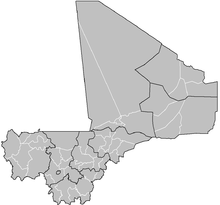
Cercles of Mali
Encyclopedia
A cercle
Cercle
Cercle is French for circle. It can also refer to:* Cercle an administrative unit of the French Overseas Empire* Cercle , the Malian administrative unit** The specific Cercles of Mali...
is the second level administrative unit in Mali
Mali
Mali , officially the Republic of Mali , is a landlocked country in Western Africa. Mali borders Algeria on the north, Niger on the east, Burkina Faso and the Côte d'Ivoire on the south, Guinea on the south-west, and Senegal and Mauritania on the west. Its size is just over 1,240,000 km² with...
. Mali is divided into eight regions
Regions of Mali
||Mali is divided into eight regions and one capital district. Each of the regions bears the name of its principal city. The regions are divided into 49 cercles. The cercles and the capital district are divided into 703 communes....
and one capital district (Bamako
Bamako
Bamako is the capital of Mali and its largest city with a population of 1.8 million . Currently, it is estimated to be the fastest growing city in Africa and sixth fastest in the world...
). These subdivisions bear the name of their principal city. The regions are divided into 49 cercles.
During French
France
The French Republic , The French Republic , The French Republic , (commonly known as France , is a unitary semi-presidential republic in Western Europe with several overseas territories and islands located on other continents and in the Indian, Pacific, and Atlantic oceans. Metropolitan France...
colonial rule in Mali
Mali
Mali , officially the Republic of Mali , is a landlocked country in Western Africa. Mali borders Algeria on the north, Niger on the east, Burkina Faso and the Côte d'Ivoire on the south, Guinea on the south-west, and Senegal and Mauritania on the west. Its size is just over 1,240,000 km² with...
, a cercle was the smallest unit of French political administration that was headed by a European
European ethnic groups
The ethnic groups in Europe are the various ethnic groups that reside in the nations of Europe. European ethnology is the field of anthropology focusing on Europe....
officer. A cercle consisted of several cantons, each of which in turn consisted of several villages. In 1887 the Cercle of Bafoulabé
Bafoulabé
Bafoulabé is a town and commune in south-western Mali. It is located in the Region of Kayes. Bafoulabé is the capital of the Cercle of Bafoulabé, which in 1887 was the first Cercle to be created in Mali.-Local administration:...
was the first cercle to be created in Mali. In most of former French West Africa
French West Africa
French West Africa was a federation of eight French colonial territories in Africa: Mauritania, Senegal, French Sudan , French Guinea , Côte d'Ivoire , Upper Volta , Dahomey and Niger...
, the term cercle was changed to Prefecture
Prefecture
A prefecture is an administrative jurisdiction or subdivision in any of various countries and within some international church structures, and in antiquity a Roman district governed by an appointed prefect.-Antiquity:...
or Department after independence.
Some cercles (and the district) were, prior to the 1999 local government reorganisation, further divided into Arrondissements
Arrondissements of Mali
||The cercles of Mali are divided into arrondissements. These are further divided into 703 communes, 19 urban communes and 684 rural communes. Unlike Communes or Cercles, Arrondissements have no administrative power or elected officials: they are merely territorial divisions or used to divide...
, especially in urban areas or the vast northern regions (such as Kidal), which consisted of a collection of Communes. Since these reforms, cercles are now directly subdivided into rural and urban communes, which in turn are divided in Quartiers (Quarters, or Villages and encampments in rural areas) which have elected councils at each level. There are 703 communes
Communes of Mali
A Commune is the third level administrative unit in Mali. Mali is divided into eight regions and one capital district . These subdivisions bear the name of their principal city. The regions are divided into 49 Cercles...
, 36 urban communes and 667 rural communes. The cercles are listed below.
Bamako Capital DistrictBamakoBamako is the capital of Mali and its largest city with a population of 1.8 million . Currently, it is estimated to be the fastest growing city in Africa and sixth fastest in the world...
- BamakoBamakoBamako is the capital of Mali and its largest city with a population of 1.8 million . Currently, it is estimated to be the fastest growing city in Africa and sixth fastest in the world...
Gao RegionGao RegionThe Gao Region is located in eastern Mali. The region's capital city is Gao. Gao Region is bordered to the south and east by Niger, to the north by Kidal Region, and to the west by Tombouctou Region. Common ethnicities in the Gao Region include the Songhai, Bozo, Tuareg, Bambara, and Kounta...
- Ansongo CercleAnsongo CercleAnsongo Cercle is an administrative subdivision of the Gao Region of Mali. The administrative center is the town of Ansongo. The Niger River passes through the cercle and plays an important role in transportation and the economy in the region.The cercle is divided into seven...
- Bourem CercleBourem CercleBourem Cercle is an administrative subdivision of the Gao Region of south-eastern Mali. The administrative center is the town of Bourem.The cercle is divided into five communes:*Bamba*Bourem*Taboye*Tarkint*Temera-References:...
- Gao CercleGao CercleGao Cercle is an administrative subdivision of the Gao Region of south-eastern Mali. The administrative center is the town of Gao.The cercle is divided into seven communes:* Anchawadi* Gabero* Gao * Gounzoureye* N'Tillit...
- Menaka CercleMenaka CercleMénaka Cercle is an administrative subdivision of the Gao Region of Mali. Its administrative center is the town of Ménaka. Ménaka Cercle's population as of 2009 was 56,104 people. Ménaka Cercle is a rural, isolated, and largely desert area, crisscrossed by seasonal wadis, part of an ancient dry...
Kayes RegionKayes RegionKayes Region is one of eight first level national subdivisions, called Regions in Mali. It is the first administrative area of Mali and covers an area of 120,760 km²...
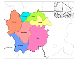
- Bafoulabé CercleBafoulabé CercleBafoulabé Cercle is a second level administrative subdivision of the Kayes Region in western Mali. Its capital is the commune of Bafoulabé.The Cercle contains the following Rural and Urban Communes:*Bafoulabé *Bamafele *Diakon...
- Diema CercleDiema CercleDiéma Cercle is an administrative subdivision of the Kayes Region of Mali. Its administrative center is the small town of Diéma. The Cercle is divided into one urban commune and fourteen rural communes...
- Kita CercleKita CercleKita Cercle is an administrative subdivision of the Kayes Region of Mali. Its capital is the city of Kita. The Cercle is further divided into Arrondissements and Communes. Kita Cercle's population as of 1998 was 278,111 people....
- Kéniéba CercleKenieba CercleKéniéba Cercle is an administrative subdivision of the Kayes Region of Mali. Its capital is the town of Kéniéba. The Cercle is further divided into Communes.Kéniéba Cercle includes the following communes:*Baye*Dabia*Dialafara*Dombia*Faléa*Faraba...
- Kayes CercleKayes CercleKayes Cercle is an administrative subdivision of the Kayes Region of Mali. Its seat is the city of Kayes, which is also the capital of its Region and its largest city. The Cercle is further divided into Arrondissements and Communes. Kayes city is subdivided into Urban Communes and Wards...
- Nioro du Sahel CercleNioro du Sahel CercleNioro Cercle is an administrative subdivision of the Kayes Region of Mali. Its administrative center is the town of Nioro du Sahel...
- Yélimané CercleYélimané CercleYélimané Cercle is an administrative subdivision of the Kayes Region of Mali. Its seat is the town of Yélimané. The Cercle is further divided into Communes...
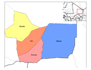
Kidal RegionKidal RegionKidal is the eighth administrative region of Mali, covering 151,430 km². Its capital is the city of Kidal.-Geography:The region is bordered on the west by Tomboctou Region, to the south by Gao Region, to the east by Niger and to the north by Algeria....
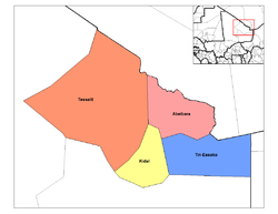
- Abeibara CercleAbeïbara CercleAbeïbara Cercle is an administrative subdivision of the Kidal Region of north-eastern Mali. The capital lies at the small town of Abeïbara. The Cercle is divided into Communes, and below this, quarters/villages. As of 2009 the cercle had a population of 10,286....
- Kidal CercleKidal CercleKidal Cercle is an administrative subdivision of the Kidal Region of Mali. The administrative center is the town of Kidal. The cercle is divided into rural and urban communes, and below this, quarters/villages. In 2009 the cercle had a population of 25,617.The climate is typical Saharian with very...
- Tessalit CercleTessalit CercleTessalit Cercle is an administrative subdivision of the Kidal Region of Mali. The capital lies at the city of Tessalit. The Cercle is divided into Communes, and below this, quarters/villages. As of 2009 the cercle had a population of 16,289...
- Tin-Essako CercleTin-Essako CercleTin-Essako Cercle is an administrative subdivision of the Kidal Region of Mali. The administrative center is at the village of Tin-Essako. As of 2009 the cercle had a population of 7,976 people...
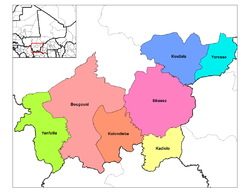
Koulikoro RegionKoulikoro RegionKoulikoro is a region in Mali. It is the second administrative area of Mali and covers an area of 90,120 km². Its capital is the city of Koulikoro.- Geography :...
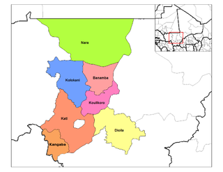
- Banamba CercleBanamba CercleBanamba Cercle is an administrative subdivision of the Koulikoro Region of Mali. Its seat is the town of Banamba, which is also its largest settlement...
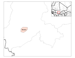
- Dioila CercleDioila CercleDioïla Cercle is an administrative subdivision of the Koulikoro Region of Mali. Its seat is the town of Dioïla. It lies at the southeast corner of the region, and prior to 1977, it was combined with what is now Kati Cercle and the District of Bamako in the "Bamako Cercle", with the capital city...
- Kangaba CercleKangaba CercleKangaba Cercle is an administrative subdivision of the Koulikoro Region of Mali. Its seat is the town and commune of Benkadi Habaladougou , also known as Kangaba...
- Koulikoro CercleKoulikoro CercleKoulikoro Cercle is an administrative subdivision of the Koulikoro Region of Mali. Its seat is the town of Koulikoro, which is also the capital of the region. A major trade and industrial town on the Niger River, Koulikoro has been surpassed by Kati to the west as the largest town in the region...
- Kolokani CercleKolokani CercleKolokani Cercle is an administrative subdivision of the Koulikoro Region of Mali. Its seat is the town of Kolokani, which is also its largest settlement. It lies directly to the north of Kati Cercle. Also to the south, is the District of Bamako, which after independence was carved out of the...
- Kati CercleKati CercleKati Cercle is an administrative subdivision of the Koulikoro Region of Mali. Its seat is the town of Kati, which is also its largest town. It lies at the southwest corner of the region, and completely surrounds the Bamako Capital District...
- Nara CercleNara CercleNara Cercle is an administrative subdivision of the Koulikoro Region of Mali. Its seat is the town of Nara, which is also the capital of its Region and its largest town. The cercle is divided into communes, and below this, Quarters/Villages....
Mopti RegionMopti RegionMopti is the fifth administrative region of Mali, covering 79,017 km². Its capital is the city of Mopti.-Geography:Mopti Region is bordered by Tombouctou Region to the north, Ségou Region to the southwest, and Burkina Faso to the southeast....
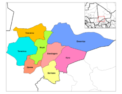
- Bandiagara CercleBandiagara CercleBandiagara Cercle is an administrative subdivision of the Mopti Region of Mali. The administrative center is the town of Bandiagara.The cercle is divided into 21 communes:*Bandiagara*Bara Sara*Borko*Dandoli*Diamnati*Dogani Béré...
- Bankass CercleBankass CercleBankass Cercle is an administrative subdivision of the Mopti Region of Mali. The administrative center is at the town of Bankass.The Cercle is divided into 12 rural communes:*Bankass*Baye*Diallassagou*Dimbal Habé*Kani Bonzon...
- Djenné CercleDjenné CercleDjenné Cercle is an administrative subdivision of the Mopti Region of Mali. The administrative center is the town of Djenné. In the 2009 census the cercle had a population of 207,260 people.-Administrative subdivisions:...
- Douentza CercleDouentza CercleDouentza Cercle is an administrative subdivision of the Mopti Region of Mali. The administrative center is the town of Douentza.The cercle is divided into 15 communes:*Dallah*Dangol-Boré*Débéré*Dianwéli*Djaptodji*Douentza*Gandamia...
- Koro CercleKoro CercleKoro Cercle is an administrative subdivision of the Mopti Region of Mali. The administrative center is the town of Koro.The cercle is divided into 16 communes:*Bamba*Barapiréli*Bondo*Diankabou*Dinangourou*Dioungani*Dougouténé I*Dougouténé II*Kassa...
- Mopti CercleMopti CercleMopti Cercle is an administrative subdivision of the Mopti Region of Mali. The administrative center is the town of Mopti.The cercle is divided into 15 communes:*Bassirou*Borondougou*Dialloubé*Fatoma*Konna*Korombana*Koubaye*Kounari...
- Tenenkou CercleTenenkou CercleTénenkou Cercle is an administrative subdivision of the Mopti Region of Mali. Its seat is the town of Ténenkou, which is also its largest town. The cercle is divided into communes.Ténenkou Cercle contains the following communes:* Diafarabé* Diaka...
- Youwarou CercleYouwarou CercleYouwarou Cercle is an administrative subdivision of the Mopti Region of Mali. The administrative center is the town of Youwarou.The cercle is divided into seven communes:*Bimbéré Tama*Déboye*Dirma*Dongo*Farimaké*N'Dodjiga*Youwarou...
Ségou RegionSégou RegionSégou is the fourth most populous administrative region in Mali, whose capital is the town of Ségou.-Geography:Situated at the center of Mali, Ségou Region covers 64,947 km²...
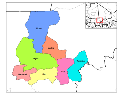
- Bla CercleBla CercleBla Cercle is an administrative subdivision of the Ségou Region of Mali. The administrative center is the town of Bla.The cercle is divided into 17 communes:*Beguené*Bla*Diaramana*Diena*Dougouolo*Falo*Fani*Kazangasso*Kemeni...
- Barouéli CercleBarouéli CercleBarouéli Cercle is an administrative subdivision of the Ségou Region of Mali. The administrative center is the town of Barouéli.The Cercle is divided into 11 communes:*Barouéli*Boidié*Dougoufié*Gouendo*Kalaké*Konobougou*N'Gassola...
- Macina CercleMacina CercleMacina Cercle is an administrative subdivision of the Ségou Region of Mali. The administrative center is the town of Macina.The cercle is divided into 11 communes:*Boky Were*Folomana*Kokry Centre*Kolongo*Macina*Matomo*Monimpebougou...
- Niono CercleNiono CercleNiono Cercle is an administrative subdivision of the Ségou Region of Mali. The administrative center is the town of Niono.The cercle is divided into 12 communes:*Diabaly*Dogofry*Kala Siguida*Mariko*Nampalari*Niono*Pogo*Siribala...
- Ségou CercleSégou CercleSégou Cercle is an administrative subdivision of the Ségou Region of Mali. The administrative center is the town of Ségou.The cercle is divided into 30 communes:*Baguindadougou*Bellen*Boussin*Cinzana*Diédougou*Diganibougou*Dioro...
- San CercleSan CercleSan Cercle is an administrative subdivision of the Ségou Region of Mali. The administrative center is the town of San.The cercle is divided into 25 communes:*Baramandougou*Dah*Diakourouna*Diéli*Djéguena*Fion*Kaniegué*Karaba*Kassorola...
- Tominian CercleTominian CercleTominian Cercle is an administrative subdivision of the Ségou Region of Mali. The administrative center of the local government is in the town of Tominian. The Cercle is divided into Communes, and below this, quarters/villages...
Sikasso RegionSikasso RegionSikasso is the southern-most region of Mali. The capital city of the same name is the 3rd-largest city and is growing rapidly due to people fleeing the violence in Côte d'Ivoire to the south. Major ethnic groups include the Senoufo, known for masks and reverence for animals, the Samago, known for...
- Bougouni CercleBougouni CercleBougouni Cercle is an administrative subdivision of the Sikasso Region of Mali. The administrative center is the town of Bougouni.The cercle is divided into 26 communes:*Bladié-Tiémala*Bougouni*Danou*Débélin*Défina*Dogo*Domba*Faradiélé...
- Kolondieba CercleKolondieba CercleKolondiéba Cercle is an administrative subdivision of the Sikasso Region of Mali. The administrative center is the town of Kolondiéba.The cercle is divided into the urban commune of Kolondiéba and 11 rural communes:*Bougoula*Fakola*Farako...
- Kadiolo CercleKadiolo CercleKadiolo Cercle is an administrative subdivision of the Sikasso Region of southern Mali. The administrative center is the town of Kadiolo.The cercle is divided into nine rural communes:*Diou*Dioumaténé*Fourou*Kadiolo*Kaï*Loulouni...
- Koutiala CercleKoutiala CercleKoutiala Cercle is an administrative subdivision of the Sikasso Region of southern Mali. The administrative center is the town of Koutiala. The Cercle is divided into 36 communes.-Economy:...
- Sikasso CercleSikasso CercleSikasso Cercle is an administrative subdivision of the Sikasso Region of southern Mali. The capital is the town of Sikasso.The cercle is divided into the urban commune of Sikasso and 43 rural communes:*Benkadi*Blendio*Danderesso*Dembela*Dialakoro...
- Yanfolila CercleYanfolila CercleYanfolila Cercle is an administrative subdivision of the Sikasso Region of southern Mali. The administrative center is the town of Yanfolila.The cercle is divided into 12 communes:*Baya*Bolo-Fouta*Djallon-Foula*Djiguiya de Koloni*Gouanan...
- Yorosso CercleYorosso CercleYorosso Cercle is an administrative subdivision of the Sikasso Region of southern Mali. The main town is Yorosso.The cercle is divided into nine rural communes:*Boura*Karangana*Kiffosso I*Koumbia*Koury*Mahou*Ménamba I*Ourikéla...
Tombouctou Region
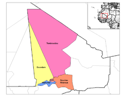
- Diré CercleDiré CercleDiré Cercle is an administrative subdivision of the Tombouctou Region of Mali. The administrative center is the town of Diré.The cercle is divided into 13 communes:*Arham*Binga*Bourem Sidi Amar*Dangha*Diré*Garbakoïra*Haïbongo...
- Goundam CercleGoundam CercleGoundam Cercle is a second level administrative subdivision of the Tombouctou Region in north-eastern Mali. Its administrative center is the town of Goundam. In the 2009 census, the cercle had a population of 150,150....
- Gourma-Rharous CercleGourma-Rharous CercleGourma-Rharous Cercle is an administrative subdivision of the Tombouctou Region of Mali. The administrative center is the town of Gourma-Rharous.The cercle is divided into nine communes:*Bambara Maoudé*Banikane*Gossi*Hamzakoma*Haribomo*Inadiatafane...
- Niafunke CercleNiafunké CercleNiafunké Cercle is an administrative subdivision of the Tombouctou Region of Mali. The administrative center is the town of Niafunké. In the 2009 census the cercle had a population of 184,285...
- Timbuktu CercleTimbuktu CercleTimbuktu Cercle is an administrative subdivision of the Tombouctou Region of Mali. It is the largest cercle by area in the whole of Mali. The capital lies at the city of Timbuktu. The Cercle is divided into Rural and Urban Communes, and below this, quarters/villages...
Colonial usage
- Benton, Lauren: Colonial Law and Cultural Difference: Jurisdictional Politics and the Formation of the Colonial State in Comparative Studies in Society and History, Vol. 41, No. 3 (Jul., 1999)
- Crowder, Michael: West Africa Under Colonial Rule Northwestern Univ. Press (1968) ASIN: B000NUU584
- Crowder, Michael: Indirect Rule: French and British Style Africa: Journal of the International African Institute, Vol. 34, No. 3 (Jul., 1964)
- Mortimer, Edward France and the Africans, 1944–1960, A Political History (1970)
- Jean Suret-Canele. French Colonialism in Tropical Africa 1900-1945. Trans. Pica Press (1971)