Chakhansur
Encyclopedia

Nimruz Province
Nimruz is one of the thirty-four provinces of Afghanistan, in the south-west of the country on the borders of Iran and Pakistan. The name Nimruz means "mid-day" or "half-day" in Persian. Nimruz covers 41,000 km² and has a population of 149,000...
in Afghanistan
Afghanistan
Afghanistan , officially the Islamic Republic of Afghanistan, is a landlocked country located in the centre of Asia, forming South Asia, Central Asia and the Middle East. With a population of about 29 million, it has an area of , making it the 42nd most populous and 41st largest nation in the world...
. Its population is approximately 406. The economy is primarily based on agriculture and the necessary water for irrigation is dependent on the status of the Sistan Basin
Sistan Basin
The Sistan Basin is an inland endorheic basin encompassing large parts of southwestern Afghanistan and southeastern Iran, one of the driest regions in the world and an area subjected to prolonged droughts...
, an endorheic basin which periodically becomes dry.
This area of Afghanistan was a major medieval cultural hub on the Silk Road
Silk Road
The Silk Road or Silk Route refers to a historical network of interlinking trade routes across the Afro-Eurasian landmass that connected East, South, and Western Asia with the Mediterranean and European world, as well as parts of North and East Africa...
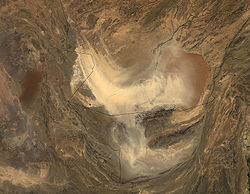
but most ancient structures are now covered by sand. Signs of historical irrigation systems, including canals, are still visible in the Chakhansur area while elsewhere canals are filled with silt
Silt
Silt is granular material of a size somewhere between sand and clay whose mineral origin is quartz and feldspar. Silt may occur as a soil or as suspended sediment in a surface water body...
and agricultural fields buried by shifting sand. Today the area is relatively sparsely populated. There continue to be problems with water control and periodic flooding and drought.
Currently the Chakhansur farmers are experiencing a severe and long term drought. Even with help from the World Food Program, many have abandoned their homes, perhaps as many as 20,000, to search for water and jobs.
Footnotes


