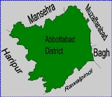
Chamhad
Encyclopedia
Chamad is one of the 51 Union Council
s (subdivisions) of Abbottabad District
in the Khyber Pakhtunkhwa province of Pakistan
.
. It has an average elevation of 870 metres (2857 feet).
Neighbouring settlements include Patian
, Baghdara
and Talhad
Union Councils of Pakistan
A sherwan or village council in Pakistan is an elected local government body consisting of 21 councillors, and headed by a nazim and a naib nazim...
s (subdivisions) of Abbottabad District
Abbottabad District
Abbottabad is a district in the Khyber Pakhtunkhwa province of Pakistan. The district covers an area of 1,969 km with the city of Abbottabad being the principal town...
in the Khyber Pakhtunkhwa province of Pakistan
Pakistan
Pakistan , officially the Islamic Republic of Pakistan is a sovereign state in South Asia. It has a coastline along the Arabian Sea and the Gulf of Oman in the south and is bordered by Afghanistan and Iran in the west, India in the east and China in the far northeast. In the north, Tajikistan...
.
Location
Chamad is located at 34°7'0N 73°4'60E, in the west of the district where it forms part of Abbottabad's border with Haripur DistrictHaripur District
Haripur is a district in the Hazara region of Khyber-Pukhtunkhwa, province of Pakistan with an altitude of around above sea level. Haripur District has the highest Human Development Index of all the districts in the Hazara....
. It has an average elevation of 870 metres (2857 feet).
Neighbouring settlements include Patian
Patian
Patian is a village of Abbottabad District in Khyber Pakhtunkhwa province of Pakistan. It is located at 34°7'15N 73°5'55E with an altitude of 958 metres . Neighbouring settlements include Chamhad, Shadial and Bagwal Bandi...
, Baghdara
Baghdara
Baghdara is a village of Abbottabad District in Khyber Pakhtunkhwa province of Pakistan. It is located at 34°8'0N 73°5'0E with an altitude of 1017 metres . Neighbouring settlements include Patian, Bagwal Bandi and Chamhad...
and Talhad

