Chatan, Okinawa
Encyclopedia
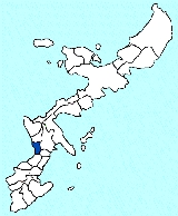
is a town
located in Nakagami District
, Okinawa
, Japan
.
In 2003, the town has an estimated population
of 26,377 and the density
of 1,936.64 per km². The total area is 13.62 km². The town is divided up into six districts: Kitamae (北前), Mihama (美浜), and Sunabe (砂辺) (which enjoy great popularity among locals and tourists alike - for their many recreational and shopping destinations) as well as the primarily local business and residential wards of Kamiseido (上製頭), Ihei (伊平), and Kuwae (桑江).
Chatan cho primarily runs along Route 58
and a largely man-made coastline which includes the area of what used be the U.S. Marine Corp base of Camp Hamby (now Camp Foster
). The northern half of Kitamae is nicknamed "Hamby Town" in recognition of this, and the Hamby Post Office is one of the first Japanese Postal offices to have an English name. Parts of Camp Foster and Camp Lester are in Chatan.
The American Kadena Air Base
is located on and forms the northern boundary of Chatan which is further demarcated by Route 23 - also known locally as Kokutai Road. The U.S. air base also encompasses much land which was once part of Chatan's area including most of the ward once named Shimoseido.
parlors, a 25-story hotel named "The Beach Tower" and several beaches. Sunabe is famous for a large sea wall which attracts many SCUBA divers and surfers.

Towns of Japan
A town is a local administrative unit in Japan. It is a local public body along with prefecture , city , and village...
located in Nakagami District
Nakagami District, Okinawa
is a district located in Okinawa, Japan.As of 2003, the district has an estimated population of 169,332 and the density of 1,216.03 persons per km²...
, Okinawa
Okinawa Prefecture
is one of Japan's southern prefectures. It consists of hundreds of the Ryukyu Islands in a chain over long, which extends southwest from Kyūshū to Taiwan. Okinawa's capital, Naha, is located in the southern part of Okinawa Island...
, Japan
Japan
Japan is an island nation in East Asia. Located in the Pacific Ocean, it lies to the east of the Sea of Japan, China, North Korea, South Korea and Russia, stretching from the Sea of Okhotsk in the north to the East China Sea and Taiwan in the south...
.
In 2003, the town has an estimated population
Population
A population is all the organisms that both belong to the same group or species and live in the same geographical area. The area that is used to define a sexual population is such that inter-breeding is possible between any pair within the area and more probable than cross-breeding with individuals...
of 26,377 and the density
Population density
Population density is a measurement of population per unit area or unit volume. It is frequently applied to living organisms, and particularly to humans...
of 1,936.64 per km². The total area is 13.62 km². The town is divided up into six districts: Kitamae (北前), Mihama (美浜), and Sunabe (砂辺) (which enjoy great popularity among locals and tourists alike - for their many recreational and shopping destinations) as well as the primarily local business and residential wards of Kamiseido (上製頭), Ihei (伊平), and Kuwae (桑江).
Chatan cho primarily runs along Route 58
Route 58 (Japan)
National Route 58 is a highway in Japan. This very unusual road has continuous numbering over disconnected segments on the islands of Kyūshū, Tanegashima, Amami Ōshima, and Okinawa. The road has a total of 255.5 km on land...
and a largely man-made coastline which includes the area of what used be the U.S. Marine Corp base of Camp Hamby (now Camp Foster
Camp Foster
Camp Foster, formerly known as Camp Zukeran, is a United States Marine Corps camp located in Ginowan City on the Japanese prefecture island of Okinawa. It is part of the Marine Corps Base Camp Smedley D. Butler complex, and named after the Medal of Honor recipient PFC William A...
). The northern half of Kitamae is nicknamed "Hamby Town" in recognition of this, and the Hamby Post Office is one of the first Japanese Postal offices to have an English name. Parts of Camp Foster and Camp Lester are in Chatan.
The American Kadena Air Base
Kadena Air Base
, is a United States Air Force base in the towns of Kadena and Chatan and the city of Okinawa, in Okinawa Prefecture, Japan. Kadena Air Base is the hub of U.S. airpower in the Pacific, and home to the USAF's 18th Wing and a variety of associate units.-Units:The 18th Wing is the host unit at Kadena...
is located on and forms the northern boundary of Chatan which is further demarcated by Route 23 - also known locally as Kokutai Road. The U.S. air base also encompasses much land which was once part of Chatan's area including most of the ward once named Shimoseido.
Shopping and recreation
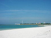
Much of the Hamby area is home to the "Hamby Free Zone". Though the name is misleading due to romanization errors, it is a large flea market that is scattered over an area of several blocks, though much of the land it is on is constantly relocated or bought for expansion of businesses. With the expansion of shopping/recreational businesses in the Mihama area, Chatan has become one of the most popular destinations for recreation. It is home to a large ferris wheel (which has become a sort of landmark), a small convention center, severa; shopping plazas, arcades, karaokeKaraoke
is a form of interactive entertainment or video game in which amateur singers sing along with recorded music using a microphone and public address system. The music is typically a well-known pop song minus the lead vocal. Lyrics are usually displayed on a video screen, along with a moving symbol,...
parlors, a 25-story hotel named "The Beach Tower" and several beaches. Sunabe is famous for a large sea wall which attracts many SCUBA divers and surfers.


