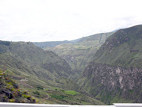
Chota, Ecuador
Encyclopedia

Ecuador
Ecuador , officially the Republic of Ecuador is a representative democratic republic in South America, bordered by Colombia on the north, Peru on the east and south, and by the Pacific Ocean to the west. It is one of only two countries in South America, along with Chile, that do not have a border...
, and the small villages in it are usually referred to as 'El Chota', and it runs east-west between the two ranges of the Andes. It lies in the provinces of Imbabura
Imbabura Province
Imbabura is a province in Ecuador. The capital is Ibarra. The people of the province speak Spanish and the Imbaburan Quechua language.Imbabura Volcano is located in the province. Best reached from the town of La Esperanza, the 4,609-meter-high mountain can be climbed in a single day.- Cantons...
, Carchi
Carchi Province
- Economy :The provincial economy is based on industrial, and agriculture productions. Carchi produces food, drinks, tobacco, and dairy products. The agriculture sector produces potatoes, maize, etc. - Cantons :The province is divided into 6 cantons...
and (to the west) Esmeraldas
Esmeraldas Province
Esmeraldas is a province in northwestern Ecuador. The capital is Esmeraldas.The province is home to the Afro-Ecuadorian culture.- Cantons :The province is divided into 8 cantons...
. The river and its upper valley are situated about halfway between the equator
Equator
An equator is the intersection of a sphere's surface with the plane perpendicular to the sphere's axis of rotation and containing the sphere's center of mass....
and the Colombia
Colombia
Colombia, officially the Republic of Colombia , is a unitary constitutional republic comprising thirty-two departments. The country is located in northwestern South America, bordered to the east by Venezuela and Brazil; to the south by Ecuador and Peru; to the north by the Caribbean Sea; to the...
n border. Accessed off Route 35, the nearest major city is Quito
Quito
San Francisco de Quito, most often called Quito , is the capital city of Ecuador in northwestern South America. It is located in north-central Ecuador in the Guayllabamba river basin, on the eastern slopes of Pichincha, an active stratovolcano in the Andes mountains...
, but Ibarra is the major market centre just south of the valley.
In the only village actually named Chota, Spanish-speaking black Creole
Creole peoples
The term Creole and its cognates in other languages — such as crioulo, criollo, créole, kriolu, criol, kreyol, kreol, kriulo, kriol, krio, etc. — have been applied to people in different countries and epochs, with rather different meanings...
villagers live here but there are eleven other Afro-Ecuadorean villages with more than 100 inhabitants in the upper Chota; the Quechua-speaking farmers live higher up in the Andes
Andes
The Andes is the world's longest continental mountain range. It is a continual range of highlands along the western coast of South America. This range is about long, about to wide , and of an average height of about .Along its length, the Andes is split into several ranges, which are separated...
mountains. Located beside the Chota River, the Chotans live from growing sugar cane, making aguardiente (brandy) and a range of other crops and raise pigs and goats. The valley bottom lies at around 1700 metres but the highway to the north and south rises quickly to over 3000 metres high.
The Chota valley people are mostly black and of African descent. Most were brought here as slaves during the colonial period, particularly when many of the great sugar estates were owned and organised by the Jesuits. Esmeraldas, to the west, is the main black area in the country. These people are supposedly descendants of slaves escaping from wrecked slave ships, just as is the black population of the Choco in Colombia. Similar black populations, descended from slaves, occur in the hot valley south of Cuenca in southern Ecuador and, to the north in Colombia, in the Patía valley.
The climate in the upper Chota valley can be hot or cool, but is consistently dusty. The valley bottom is dry (around 1000 mm.annually) and temperatures range between 16 and 29 degrees Celsius. As the valley descends towards the coast is passes through cloud forest and is more humid. Annual flooding and landslides are a dangerous problem in the rainy season. Homes are simple and most are one room only. They are made of cinder block
Cinder block
In the United States, a concrete masonry unit – also called concrete block, cement block, and foundation block – is a large rectangular brick used in construction. Concrete blocks are made from cast concrete, i.e. Portland cement and aggregate, usually sand and fine gravel for high-density blocks...
s or grass and reeds.
(Ref: permission of: Angelique, Stephen, Iceman Gone; Gibbs, James, "Japan Traveler" magazine)
See also
- Afro-Ecuadorian peopleAfro-Ecuadorian peopleAn Afro-Ecuadorian is a member of a group in Ecuador who are descendants of black African slaves brought by the Spanish during their conquest of Ecuador from the Incas. They make up from 3% to 5% of Ecuador's population....
- Bomba (Ecuador)Bomba (Ecuador)Bomba or Bomba del Chota is an Afro-Ecuadorian musical form from the Chota Valley area of Ecuador in the province of Imbabura and Carchi. Its origins can be traced back to Africa via the middle passage and the use of African slave labor during the country's colonial period...
)

