Cigelka
Encyclopedia

Village
A village is a clustered human settlement or community, larger than a hamlet with the population ranging from a few hundred to a few thousand , Though often located in rural areas, the term urban village is also applied to certain urban neighbourhoods, such as the West Village in Manhattan, New...
and municipality
Municipality
A municipality is essentially an urban administrative division having corporate status and usually powers of self-government. It can also be used to mean the governing body of a municipality. A municipality is a general-purpose administrative subdivision, as opposed to a special-purpose district...
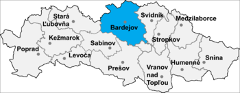
in Bardejov District
Bardejov District
Bardejov District is a district in the Prešov Region of eastern Slovakia.Until 1918, the district was part of the Hungarian county of...
in the Prešov Region
Prešov Region
The Prešov Region is one of the eight Slovak administrative regions. It consists of 13 districts.-Geography:It is located in north-eastern Slovakia and has an area of 8,975 km². The region has diverse types of landscapes occurring in Slovakia, but mostly highlands and hilly lands dominate the...
of north-east Slovakia
Slovakia
The Slovak Republic is a landlocked state in Central Europe. It has a population of over five million and an area of about . Slovakia is bordered by the Czech Republic and Austria to the west, Poland to the north, Ukraine to the east and Hungary to the south...
with Ruthenian and Roma inhabitants. It lies in the valley of Oľchovec below the Busov hill (1 002 meters above sea level) near the Slovakia-Poland border. There is a Greek Catholic church of Saints Cosmas and Damian in the year 1816, which served its first liturgy Presov later Bishop Paul Peter Gojdič.
History
In historical recordsHistory
History is the discovery, collection, organization, and presentation of information about past events. History can also mean the period of time after writing was invented. Scholars who write about history are called historians...
the village was first mentioned in 1414. In the following centuries the estate belonged to Makovica manor. In 19th century the village was affected by emigration to North America for economic reasons, in 1947 the proportion of the population at the instigation of the Soviet authorities moved to Ukraine (in particular the village Chomut, the current name Zelenyj Haj – Зелений Гай), from the 20th to the sixties the dawn of the 21st century centuries, the majority returned to Slovakia.
The village has a memorial to the victims of World War II from Cigeľka – especially the seven young boys who were sent to fight the war ended without proper training, and a few Jewish families whose members died in concentration camps. Memorial was unveiled in October 1989. Its author is a painter Mikuláš Lovacký.
Geography
The municipalityMunicipality
A municipality is essentially an urban administrative division having corporate status and usually powers of self-government. It can also be used to mean the governing body of a municipality. A municipality is a general-purpose administrative subdivision, as opposed to a special-purpose district...
lies at an altitude
Altitude
Altitude or height is defined based on the context in which it is used . As a general definition, altitude is a distance measurement, usually in the vertical or "up" direction, between a reference datum and a point or object. The reference datum also often varies according to the context...
of 526 metres and covers an area
Area
Area is a quantity that expresses the extent of a two-dimensional surface or shape in the plane. Area can be understood as the amount of material with a given thickness that would be necessary to fashion a model of the shape, or the amount of paint necessary to cover the surface with a single coat...
of 15 984 km².
It has a population
Population
A population is all the organisms that both belong to the same group or species and live in the same geographical area. The area that is used to define a sexual population is such that inter-breeding is possible between any pair within the area and more probable than cross-breeding with individuals...
of about 464 people.
Mineral water
There is a spring mineral water the same name. Almanac "Spas of Czechoslovak Republic of 1949" states as Cigeľka spa place for the treatment of gastric diseases, diseases of upper respiratory tract, heart and blood vessels, and skin diseases. At present, Cigeľka hasn't the status of spa. In addition to salt mineral water springs in Cigeľka from dozens of sources acidulous water.External links
- http://www.statistics.sk/mosmis/eng/run.html

