

City of St Kilda
Encyclopedia
The City of St Kilda was a Local Government Area located on Port Phillip
about 5 kilometres (3.1 mi) south of Melbourne
, the state capital of Victoria
, Australia
. The city covered an area of 8.7 square kilometres (3.36 sq mi), and existed from 1855 until 1994.
Council meetings were first held at the St Kilda Police Station at the St Kilda Junction
before the city's first town hall was built in 1859 on the corner of Grey and Barkly streets.
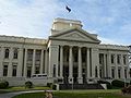
A new town hall was built for the city on the corner of Carlisle Street and Brighton Road. The site was reserved in 1883, selected in 1887 with plans drawn up by architect William Pitt
in 1888.
 On 22 June 1994, the City of St Kilda was abolished and merged into the newly-created City of Port Phillip
along with the Cities of Port Melbourne
and South Melbourne
.
The council met at the St Kilda Town Hall
at the intersection of St Kilda Road and Carlisle Street, St Kilda. The facility is now the main council chambers for the City of Port Phillip
.
and Wellington Street/Dandenong Road
to the north; Orrong Road, Inkerman Street and Hotham Street to the east, Glen Huntly Road, St Kilda Street and Head Street to the south, and Port Phillip to the west.
Suburbs within the City of St Kilda were:
* Estimate in the 1958 Victorian Year Book.
Port Phillip
Port Phillip Port Phillip Port Phillip (also commonly referred to as Port Phillip Bay or (locally) just The Bay, is a large bay in southern Victoria, Australia; it is the location of Melbourne. Geographically, the bay covers and the shore stretches roughly . Although it is extremely shallow for...
about 5 kilometres (3.1 mi) south of Melbourne
Melbourne
Melbourne is the capital and most populous city in the state of Victoria, and the second most populous city in Australia. The Melbourne City Centre is the hub of the greater metropolitan area and the Census statistical division—of which "Melbourne" is the common name. As of June 2009, the greater...
, the state capital of Victoria
Victoria (Australia)
Victoria is the second most populous state in Australia. Geographically the smallest mainland state, Victoria is bordered by New South Wales, South Australia, and Tasmania on Boundary Islet to the north, west and south respectively....
, Australia
Australia
Australia , officially the Commonwealth of Australia, is a country in the Southern Hemisphere comprising the mainland of the Australian continent, the island of Tasmania, and numerous smaller islands in the Indian and Pacific Oceans. It is the world's sixth-largest country by total area...
. The city covered an area of 8.7 square kilometres (3.36 sq mi), and existed from 1855 until 1994.
History
St Kilda was first incorporated as a district on 24 April 1855, and became a Borough in April 1863. It was proclaimed a City on 8 September 1890.Council meetings were first held at the St Kilda Police Station at the St Kilda Junction
St Kilda Junction
St Kilda Junction is one of the most notorious intersections in Melbourne, Australia. It is located in the suburb of St Kilda, and bordering Windsor, Melbourne and St Kilda East, and is the meeting point of the major roads Punt Road, St Kilda Road, Dandenong Road/Queens Way/Princes Highway and...
before the city's first town hall was built in 1859 on the corner of Grey and Barkly streets.
A new town hall was built for the city on the corner of Carlisle Street and Brighton Road. The site was reserved in 1883, selected in 1887 with plans drawn up by architect William Pitt
William Pitt (architect)
William Pitt born in Melbourne was an architect, public servant and politician working in Victoria, Australia in the later part of the 19th century and early 20th century....
in 1888.
City of Port Phillip
The City of Port Phillip is a Local Government Area in Victoria, Australia. It is located on the northern shores of Port Phillip, south of Melbourne's central business district. It has an area of 20.62 km² and has an estimated population of 96,110 people....
along with the Cities of Port Melbourne
City of Port Melbourne
The City of Port Melbourne was a Local Government Area located about southwest of Melbourne, the state capital of Victoria, Australia, on the south bank of the Yarra River...
and South Melbourne
City of South Melbourne
The City of South Melbourne was a Local Government Area located about south of Melbourne, the state capital of Victoria, Australia, on the south bank of the Yarra River...
.
The council met at the St Kilda Town Hall
St Kilda Town Hall
St Kilda Town Hall is a city hall in St Kilda, Victoria, Australia.-Architecture:The design by local architect William Pitt in the Classical Revival style. It was built in 1890. Pitt's grand vision for the town hall was never completed...
at the intersection of St Kilda Road and Carlisle Street, St Kilda. The facility is now the main council chambers for the City of Port Phillip
City of Port Phillip
The City of Port Phillip is a Local Government Area in Victoria, Australia. It is located on the northern shores of Port Phillip, south of Melbourne's central business district. It has an area of 20.62 km² and has an estimated population of 96,110 people....
.
Wards
St Kilda was divided into four wards on 5 April 1987, each electing three councillors:- North Ward
- West Ward
- Centre Ward
- South Ward
Suburbs
The council area was bounded by Fraser and Lorne Streets, Punt RoadHoddle Highway
Hoddle Highway is an urban highway in Melbourne linking CityLink and the Eastern Freeway, allotted metropolitan route . The name "Hoddle Highway" is almost completely unknown to most drivers - who refer instead to its constituent parts: Hoddle Street and Punt Road.It starts at the Eastern Freeway...
and Wellington Street/Dandenong Road
Princes Highway
The Princes Highway extends from Sydney to Port Augusta via the coast through the states of New South Wales, Victoria and South Australia, a distance of 1941 km or 1898 km via the former alignments of the highway ....
to the north; Orrong Road, Inkerman Street and Hotham Street to the east, Glen Huntly Road, St Kilda Street and Head Street to the south, and Port Phillip to the west.
Suburbs within the City of St Kilda were:
- BalaclavaBalaclava, VictoriaBalaclava is a suburb of Melbourne, Victoria, in Australia. It is situated in the south-east of the city in the St Kilda East area and is bounded by Inkerman Street to the north, Chapel Street to the west, Hotham Street to the east and Oak Grove and Los Angeles Court to the south. In terms of its...
- ElwoodElwood, VictoriaElwood is a suburb in Melbourne, Victoria, Australia, 8 km south from Melbourne's central business district. Its Local Government Area is the City of Port Phillip...
- RipponleaRipponlea, VictoriaRipponlea is a suburb of Melbourne, Victoria, Australia. It is centered on the intersection of Glen Eira Road and Hotham Street, in the municipality of City of Port Phillip. In terms of its cadastral division, Ripponlea is in the parish of Prahran within the County of Bourke. As of the 2006 Census,...
- St KildaSt Kilda, VictoriaSt Kilda is an inner city suburb of Melbourne, Victoria, Australia, 6 km south from Melbourne's central business district. Its Local Government Area is the City of Port Phillip...
- St Kilda EastSt Kilda East, VictoriaSt Kilda East is a suburb in Melbourne, Victoria, Australia, 6 km south-east of Melbourne's central business district. It is located within the Local Government Areas of the City of Glen Eira and the City of Port Phillip. At the 2006 Census, it had a population of 12,188.St Kilda East is one...
(shared with City of CaulfieldCity of CaulfieldThe City of Caulfield was a Local Government Area located about southeast of Melbourne, the state capital of Victoria, Australia. The city covered an area of , and existed from 1857 until 1994.-History:...
)
Population
| Year | Population |
|---|---|
| 1861 | 6,408 |
| 1901 | 20,542 |
| 1921 | 38,579 |
| 1947 | 58,318 |
| 1954 | 53,301 |
| 1958 | 51,200* |
| 1961 | 52,205 |
| 1966 | 58,179 |
| 1971 | 61,203 |
| 1976 | 51,254 |
| 1981 | 49,366 |
| 1986 | 45,889 |
| 1991 | 45,481 |
* Estimate in the 1958 Victorian Year Book.