Clapham, North Yorkshire
Encyclopedia
Clapham is a village in the Craven district
of North Yorkshire
, England
. It was previously in the West Riding of Yorkshire
. It lies within the Yorkshire Dales National Park
6 miles north west of Settle
just off the A65
.
 The church of St. James in Clapham was founded in Norman times, and was originally dedicated to St. Michael. It is mentioned in records dating back to 1160. Unfortunately, it and the rest of the village were burned during a Scottish raid following the Battle of Bannockburn
in the early 14th-century. The church tower was probably erected following this incident, but the rest of the church dates from the 19th-century.
In the 14th century John de Clapham, who took his surname from the village, was a supporter of the earl of Warwick
and lived at Clapdale Castle. His ancestors took part in the Wars of the Roses
, albeit on the side of the House of Lancaster
.
Since the 18th century Clapham has been home to the Farrer family who established their Ingleborough estate. The family owns and is responsible for much of the land, walls, woods, fields and moors of the village, surrounding countryside and farms.
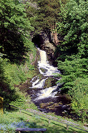
Electricity has been generated on the Ingleborough estate since 1893. There is an operating water turbine-powered generator at the top of the village next to the waterfall. It was installed in 1948. Originally it supplied the church, Ingleborough Hall, Home Farm and 13 street lights. There is another turbine in the sawmill which is in use although it is now helped by an electric motor when the larger saw is in use.
In August 1947 the Trow Ghyll skeleton
was discovered in a cave above the village.
 Clapham is situated at the base of Ingleborough
mountain (one of Yorkshire's famous "Three Peaks
" - Ingleborough, Whernside
and Pen-y-ghent
) and is a well known starting point for its ascent.
Running through the village is Clapham Beck. This is fed from Fell Beck which starts on the slopes of Ingleborough and sinks into Gaping Gill
, England's highest waterfall, where Fell Beck drops 110 metres vertically down a pothole, and exits via Ingleborough Cave
into Clapham Beck. The beck then feeds into the River Lune
via the River Wenning
. The beck is crossed by four bridges in the village (two footbridges: Brokken Bridge and Mafeking Bridge, and two road bridges).
Above the village is a man-made lake built and expanded in the 19th century. This provided pressure for the water turbines and the drinking water supply, while the outflow fed an artificial waterfall at the top of the village.
Clapham lies on the Craven fault zone. This is a complex geological fault which marks the division of the sandstone
rocks of the Bowland
area and the limestone
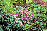
of the Ingleborough area. However, the valley of Clapham Beck has cut through the limestone and into the underlying Ordovician basement. The basement rocks produces soils that are acid, and not alkaline like those on the limestone. This is beneficial to the many species of rhododendron
that have been planted along Clapdale and which would suffer in alkaline soils.
(1880–1920) was born and lived in Clapham. He collected many new species of rhododendrons, shrubs and alpines in China
, Tibet
and Upper Burma
between 1914 and 1920. Many of these were planted on the Estate by Farrer. In some places he fired seeds at cliff faces from a shotgun, to give a ‘natural’ spread to his rock plants.

Up until 2000 the Dalesman magazine was based in the village.
Being within the Yorkshire Dales National Park, the car park is run by the national park with fees going directly to them.
Ingleborough Cave
is a show cave open to the public, accessed through the grounds of the Ingleborough Estate. Beyond the show cave the path continues through the impressive gorge of Trow Gill and hence to Gaping Gill. Local caving clubs set up a winch down Gaping Gill
during the Spring and August bank holidays, which is open to the general public.
Based in the village is the Cave Rescue Organisation
which serves people and animals above and below ground across a wide area of the Dales.
The village is served by Clapham railway station
which is situated one mile away.
Craven
Craven is a local government district in North Yorkshire, England that came into being in 1974, centred on the market town of Skipton. In the changes to British local government of that year this district was formed as the merger of Skipton urban district, Settle Rural District and most of Skipton...
of North Yorkshire
North Yorkshire
North Yorkshire is a non-metropolitan or shire county located in the Yorkshire and the Humber region of England, and a ceremonial county primarily in that region but partly in North East England. Created in 1974 by the Local Government Act 1972 it covers an area of , making it the largest...
, England
England
England is a country that is part of the United Kingdom. It shares land borders with Scotland to the north and Wales to the west; the Irish Sea is to the north west, the Celtic Sea to the south west, with the North Sea to the east and the English Channel to the south separating it from continental...
. It was previously in the West Riding of Yorkshire
West Riding of Yorkshire
The West Riding of Yorkshire is one of the three historic subdivisions of Yorkshire, England. From 1889 to 1974 the administrative county, County of York, West Riding , was based closely on the historic boundaries...
. It lies within the Yorkshire Dales National Park
Yorkshire Dales
The Yorkshire Dales is the name given to an upland area in Northern England.The area lies within the historic county boundaries of Yorkshire, though it spans the ceremonial counties of North Yorkshire, West Yorkshire and Cumbria...
6 miles north west of Settle
Settle
Settle is a small market town and civil parish within the Craven district of North Yorkshire, England. It is served by the Settle railway station, which is located near the town centre, and Giggleswick railway station which is a mile away. It is from Leeds Bradford Airport...
just off the A65
A65 road
The A65 is a major road in England. It runs north west from Leeds in Yorkshire via Kirkstall, Horsforth, Yeadon, Guiseley, Ilkley and Skipton, passes west of Settle, then continues through Ingleton and Kirkby Lonsdale before terminating at Kendal in Cumbria....
.
History

Bannockburn
Bannockburn is a village immediately south of the city of Stirling in Scotland. It is named after the Bannock Burn, a burn running through the village before flowing into the River Forth.-History:...
in the early 14th-century. The church tower was probably erected following this incident, but the rest of the church dates from the 19th-century.
In the 14th century John de Clapham, who took his surname from the village, was a supporter of the earl of Warwick
Earl of Warwick
Earl of Warwick is a title that has been created four times in British history and is one of the most prestigious titles in the peerages of the British Isles.-1088 creation:...
and lived at Clapdale Castle. His ancestors took part in the Wars of the Roses
Wars of the Roses
The Wars of the Roses were a series of dynastic civil wars for the throne of England fought between supporters of two rival branches of the royal House of Plantagenet: the houses of Lancaster and York...
, albeit on the side of the House of Lancaster
House of Lancaster
The House of Lancaster was a branch of the royal House of Plantagenet. It was one of the opposing factions involved in the Wars of the Roses, an intermittent civil war which affected England and Wales during the 15th century...
.
Since the 18th century Clapham has been home to the Farrer family who established their Ingleborough estate. The family owns and is responsible for much of the land, walls, woods, fields and moors of the village, surrounding countryside and farms.
Electricity has been generated on the Ingleborough estate since 1893. There is an operating water turbine-powered generator at the top of the village next to the waterfall. It was installed in 1948. Originally it supplied the church, Ingleborough Hall, Home Farm and 13 street lights. There is another turbine in the sawmill which is in use although it is now helped by an electric motor when the larger saw is in use.
In August 1947 the Trow Ghyll skeleton
Trow Ghyll skeleton
The Trow Ghyll skeleton is a set of human remains discovered on August 24, 1947 in a cave near Clapham in the West Riding of Yorkshire. It was named after a prominent topographical feature located some away. Although the identity of the body has never been ascertained, it has been claimed that...
was discovered in a cave above the village.
Geography

Ingleborough
Ingleborough is the second highest mountain in the Yorkshire Dales. It is one of the Yorkshire Three Peaks, the other two being Whernside and Pen-y-ghent. Ingleborough is frequently climbed as part of the Yorkshire Three Peaks Challenge, which is a 24-mile circular challenge walk starting and...
mountain (one of Yorkshire's famous "Three Peaks
Yorkshire three peaks
The mountains of Whernside , Ingleborough and Pen-y-ghent are collectively known as the Three Peaks. The peaks, which form part of the...
" - Ingleborough, Whernside
Whernside
Whernside is a mountain in the Yorkshire Dales and is one of the Yorkshire Three Peaks, the other two being Ingleborough and Pen-y-ghent. It is the highest point in the ceremonial county of North Yorkshire,Mickle Fell in southern Teesdale is the highest point within the boundaries of the historic...
and Pen-y-ghent
Pen-y-ghent
Pen-y-ghent is a fell in the Yorkshire Dales. It is one of the Yorkshire Three Peaks, the other two being Ingleborough and Whernside. It lies some 3 km east of Horton in Ribblesdale...
) and is a well known starting point for its ascent.
Running through the village is Clapham Beck. This is fed from Fell Beck which starts on the slopes of Ingleborough and sinks into Gaping Gill
Gaping Gill
Gaping Gill is a natural cave in North Yorkshire, England. It is one of the unmistakable landmarks on the southern slopes of Ingleborough – a deep pothole with the stream Fell Beck flowing into it...
, England's highest waterfall, where Fell Beck drops 110 metres vertically down a pothole, and exits via Ingleborough Cave
Ingleborough Cave
Ingleborough Cave is a show cave close to the village of Clapham, North Yorkshire, England adjacent to where the water from Gaping Gill resurges....
into Clapham Beck. The beck then feeds into the River Lune
River Lune
The River Lune is a river in Cumbria and Lancashire, England.It is formed at Wath, in the parish of Ravenstonedale, Cumbria, at the confluence of Sandwath Beck and Weasdale Beck...
via the River Wenning
River Wenning
The River Wenning is a tributary of the River Lune, flowing through North Yorkshire and Lancashire. The Wenning rises at Clapham in Yorkshire and flows westwards through High Bentham, Low Bentham and Wennington....
. The beck is crossed by four bridges in the village (two footbridges: Brokken Bridge and Mafeking Bridge, and two road bridges).
Above the village is a man-made lake built and expanded in the 19th century. This provided pressure for the water turbines and the drinking water supply, while the outflow fed an artificial waterfall at the top of the village.
Clapham lies on the Craven fault zone. This is a complex geological fault which marks the division of the sandstone
Sandstone
Sandstone is a sedimentary rock composed mainly of sand-sized minerals or rock grains.Most sandstone is composed of quartz and/or feldspar because these are the most common minerals in the Earth's crust. Like sand, sandstone may be any colour, but the most common colours are tan, brown, yellow,...
rocks of the Bowland
Forest of Bowland
The Forest of Bowland, also known as the Bowland Fells, is an area of barren gritstone fells, deep valleys and peat moorland, mostly in north-east Lancashire, England. A small part lies in North Yorkshire, and much of the area was historically part of the West Riding of Yorkshire...
area and the limestone
Limestone
Limestone is a sedimentary rock composed largely of the minerals calcite and aragonite, which are different crystal forms of calcium carbonate . Many limestones are composed from skeletal fragments of marine organisms such as coral or foraminifera....
of the Ingleborough area. However, the valley of Clapham Beck has cut through the limestone and into the underlying Ordovician basement. The basement rocks produces soils that are acid, and not alkaline like those on the limestone. This is beneficial to the many species of rhododendron
Rhododendron
Rhododendron is a genus of over 1 000 species of woody plants in the heath family, most with showy flowers...
that have been planted along Clapdale and which would suffer in alkaline soils.
Famous residents
The notable botanist Reginald FarrerReginald Farrer
Reginald John Farrer , was a traveller and plant collector. He published a number of books, although is best known for My Rock Garden...
(1880–1920) was born and lived in Clapham. He collected many new species of rhododendrons, shrubs and alpines in China
People's Republic of China
China , officially the People's Republic of China , is the most populous country in the world, with over 1.3 billion citizens. Located in East Asia, the country covers approximately 9.6 million square kilometres...
, Tibet
Tibet
Tibet is a plateau region in Asia, north-east of the Himalayas. It is the traditional homeland of the Tibetan people as well as some other ethnic groups such as Monpas, Qiang, and Lhobas, and is now also inhabited by considerable numbers of Han and Hui people...
and Upper Burma
Myanmar
Burma , officially the Republic of the Union of Myanmar , is a country in Southeast Asia. Burma is bordered by China on the northeast, Laos on the east, Thailand on the southeast, Bangladesh on the west, India on the northwest, the Bay of Bengal to the southwest, and the Andaman Sea on the south....
between 1914 and 1920. Many of these were planted on the Estate by Farrer. In some places he fired seeds at cliff faces from a shotgun, to give a ‘natural’ spread to his rock plants.

Local businesses and amenities
The village contains Clapham CE Primary School, a village hall, one pub (the New Inn), a local shop and post office, a small number of businesses, guest houses, and an outdoor education centre.Up until 2000 the Dalesman magazine was based in the village.
Being within the Yorkshire Dales National Park, the car park is run by the national park with fees going directly to them.
Ingleborough Cave
Ingleborough Cave
Ingleborough Cave is a show cave close to the village of Clapham, North Yorkshire, England adjacent to where the water from Gaping Gill resurges....
is a show cave open to the public, accessed through the grounds of the Ingleborough Estate. Beyond the show cave the path continues through the impressive gorge of Trow Gill and hence to Gaping Gill. Local caving clubs set up a winch down Gaping Gill
Gaping Gill
Gaping Gill is a natural cave in North Yorkshire, England. It is one of the unmistakable landmarks on the southern slopes of Ingleborough – a deep pothole with the stream Fell Beck flowing into it...
during the Spring and August bank holidays, which is open to the general public.
Based in the village is the Cave Rescue Organisation
Mountain rescue in England and Wales
Mountain rescue services in England and Wales operate under the umbrella association of the MREW - Mountain Rescue...
which serves people and animals above and below ground across a wide area of the Dales.
The village is served by Clapham railway station
Clapham railway station
Clapham railway station serves the village of Clapham in North Yorkshire, England. The station is north west of Leeds on the Leeds to Morecambe Line towards Lancaster and Morecambe. It is managed by Northern Rail who provide all passenger train services....
which is situated one mile away.

