
Claremont Canyon Regional Preserve
Encyclopedia

Regional park
Regional park is a term used for an area of land preserved on account of its natural beauty, historic interest, recreational use or other reason, and under the administration of a form of local government.-Definition:...
mainly located in the city of Oakland, California
Oakland, California
Oakland is a major West Coast port city on San Francisco Bay in the U.S. state of California. It is the eighth-largest city in the state with a 2010 population of 390,724...
, and administered by the East Bay Regional Park District
East Bay Regional Park District
The East Bay Regional Park District is a special district operating in Alameda County and Contra Costa County, California, within the East Bay area of the San Francisco Bay Area...
. The park is named for the canyon in which it's situated, Claremont Canyon, out of which Claremont Creek flows on its way to its confluence with Temescal Creek. Originally, the canyon was named "Harwood's Canyon", then "Telegraph Canyon". The name was changed to Claremont by a developer of the nearby Claremont
Claremont, Oakland/Berkeley, California
The Claremont district is a neighborhood straddling the city limits of Oakland and Berkeley in the East Bay section of the San Francisco Bay Area in California, United States. It lies at an elevation of 266 feet . The main thoroughfares are Claremont and Ashby Avenues.The name was given in the...
district.
Despite its small size of 205 acres (83 ha), Claremont Canyon Regional Preserve forms an important link in the chain of parks that line the Berkeley Hills
Berkeley Hills
The Berkeley Hills are a range of the Pacific Coast Ranges that overlook the northeast side of the valley that surrounds San Francisco Bay. They were previously called the "Contra Costa Range/Hills" , but with the establishment of Berkeley and the University of California, the current usage was...
. It rises from a height of about 420 ft (130 m) above sea level, just behind the Clark Kerr campus of the University of California, Berkeley
University of California, Berkeley
The University of California, Berkeley , is a teaching and research university established in 1868 and located in Berkeley, California, USA...
to the average 1300 ft (400 m) ridge of the East Bay hills, linking by way of other conserved land belonging to the University and the East Bay Municipal Utility District
East Bay Municipal Utility District
East Bay Municipal Utility District , colloquially referred to as "East Bay Mud", provides water and sewage treatment for customers in portions of Alameda County and Contra Costa County in California, on the eastern side of San Francisco Bay, including the cities of Richmond, El Cerrito, Hercules,...
to other parks such as Tilden Regional Park
Tilden Regional Park
Tilden Regional Park, also known as "Tilden" , is a regional park in the East Bay, part of the San Francisco Bay Area in California. It is situated between the Berkeley Hills and San Pablo Ridge....
and Sibley Volcanic Regional Preserve. It thus offers direct pedestrian access to the park system, with connections to public transportation, from the lower-lying residential areas of Berkeley
Berkeley, California
Berkeley is a city on the east shore of the San Francisco Bay in Northern California, United States. Its neighbors to the south are the cities of Oakland and Emeryville. To the north is the city of Albany and the unincorporated community of Kensington...
and Oakland.
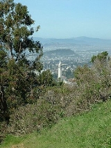
The steep path up to the ridge gives splendid views across the cities of Berkeley and Oakland, and beyond to San Francisco Bay
San Francisco Bay
San Francisco Bay is a shallow, productive estuary through which water draining from approximately forty percent of California, flowing in the Sacramento and San Joaquin rivers from the Sierra Nevada mountains, enters the Pacific Ocean...
, the Golden Gate Bridge
Golden Gate Bridge
The Golden Gate Bridge is a suspension bridge spanning the Golden Gate, the opening of the San Francisco Bay into the Pacific Ocean. As part of both U.S. Route 101 and California State Route 1, the structure links the city of San Francisco, on the northern tip of the San Francisco Peninsula, to...
and San Francisco
San Francisco, California
San Francisco , officially the City and County of San Francisco, is the financial, cultural, and transportation center of the San Francisco Bay Area, a region of 7.15 million people which includes San Jose and Oakland...
; on clear days, especially in winter, the Farallon Islands
Farallon Islands
The Farallon Islands, or Farallones , are a group of islands and sea stacks in the Gulf of the Farallones, off the coast of San Francisco, California, USA. They lie outside the Golden Gate and south of Point Reyes, and are visible from the mainland on clear days...
, about 44 miles (70 km) away, can be seen beyond the Golden Gate.
Within the Preserve is a side canyon called Gwin Canyon with a 2 miles (3.2 km) trail accessible from the end of Norfolk Road near Strathmoor Drive in the Oakland Hills.
While the upper reaches of Claremont Canyon are technically outside the Preserve, there are an additional 225 acre (0.9105435 km²) of open space contiguous to it owned and managed by the University of California
University of California
The University of California is a public university system in the U.S. state of California. Under the California Master Plan for Higher Education, the University of California is a part of the state's three-tier public higher education system, which also includes the California State University...
. A local non-profit citizens' organization, the Claremont Canyon Conservancy
Claremont Canyon Conservancy
The Claremont Canyon Conservancy provides stewardship and educational programs to its members and the public regarding the , mostly wildland, Claremont Canyon at the Oakland/Berkeley border in Northern California. The conservancy grew out of a citizen-based task force formed after the 1991...
, works with the public landowners offering stewardship services and educational programs.
37.8652037°N 122.2258013°W