Coal tax post
Encyclopedia


London
London is the capital city of :England and the :United Kingdom, the largest metropolitan area in the United Kingdom, and the largest urban zone in the European Union by most measures. Located on the River Thames, London has been a major settlement for two millennia, its history going back to its...
, England
England
England is a country that is part of the United Kingdom. It shares land borders with Scotland to the north and Wales to the west; the Irish Sea is to the north west, the Celtic Sea to the south west, with the North Sea to the east and the English Channel to the south separating it from continental...
, to mark the points where taxes on coal
Coal
Coal is a combustible black or brownish-black sedimentary rock usually occurring in rock strata in layers or veins called coal beds or coal seams. The harder forms, such as anthracite coal, can be regarded as metamorphic rock because of later exposure to elevated temperature and pressure...
and wine
Wine
Wine is an alcoholic beverage, made of fermented fruit juice, usually from grapes. The natural chemical balance of grapes lets them ferment without the addition of sugars, acids, enzymes, or other nutrients. Grape wine is produced by fermenting crushed grapes using various types of yeast. Yeast...
due to the Corporation of London had to be paid.
History
Coal sold in the City of LondonCity of London
The City of London is a small area within Greater London, England. It is the historic core of London around which the modern conurbation grew and has held city status since time immemorial. The City’s boundaries have remained almost unchanged since the Middle Ages, and it is now only a tiny part of...
had been taxed since mediaeval times and, as it was all brought in by sea to one or two riverside wharfs, the collection of the duty had been relatively easy. A similar duty was collected on all wine landed in London. By the nineteenth century, however, there was increasing trade by canal and rail, and various acts of parliament extended the catchment area to a radius of about twenty miles from London, From Colnbrook
Colnbrook
Colnbrook is a large village in the unitary authority of Slough, in Berkshire, England. It is situated southeast of central Slough, east of Windsor and west of central London....
in the west to Gravesend
Gravesend, Kent
Gravesend is a town in northwest Kent, England, on the south bank of the Thames, opposite Tilbury in Essex. It is the administrative town of the Borough of Gravesham and, because of its geographical position, has always had an important role to play in the history and communications of this part of...
and Crayford Ness, by the mouth of the Darent
River Darent
The River Darent or River Darenth is a Kentish tributary of the River Thames in England. Its name is believed to be from a Celtic word meaning 'river where oak-trees grow'...
, in the east. The City
City of London
The City of London is a small area within Greater London, England. It is the historic core of London around which the modern conurbation grew and has held city status since time immemorial. The City’s boundaries have remained almost unchanged since the Middle Ages, and it is now only a tiny part of...
is a small (one square mile) but influential part of London and in 1851 an Act was passed specifying the points, far beyond its boundaries, where the collections could be made. Marker posts, inscribed with this legal authority, were erected. About two hundred have survived. Following enlargement of the Metropolitan Police District
Metropolitan Police District
The Metropolitan Police District is the police area which is policed by London's Metropolitan Police Service. It currently consists of Greater London, excluding the City of London.-History:...
(which, paradoxically, did not include the City of London) in 1861 a further Act was passed and new marker posts were set to show the boundary inside which the duty was payable. Most of these later posts survive.
Not all of the points were staffed by tax collectors but on well-used routes with a heavy coal traffic, such as on the Grand Union Canal
Grand Union Canal
The Grand Union Canal in England is part of the British canal system. Its main line connects London and Birmingham, stretching for 137 miles with 166 locks...
at Grove Park, Hertfordshire, permanent toll houses were built. In other cases local coal merchants or, after the bulk of the traffic had passed to the railway, the railway companies calculated the sums due and passed the money to the Corporation. The railway companies were allowed to offset the coal they used for their engines, but only when employed on coal trains.
The erection of these posts was very much a last ditch attempt to retain the tax in the face of growing opposition. The tax had been running for at least two hundred years but within twenty years of the posts going up it was abolished. The Industrial Revolution was in full swing, London was expanding rapidly. The outer suburbs were becoming towns and their residents beginning to resent paying a tax which had very little direct benefit for them. One extreme case is Caterham
Caterham
Caterham is a town in the Tandridge District of Surrey, England. The town is geographically divided into two sections: Caterham on the Hill and Caterham Valley - the main town centre. The town lies close to the A22, a few miles south of Croydon, in a valley cut into the dip slope of the North Downs...
which lay (and still lies) outside the Metropolitan Police District (MPD) but if coals were to be brought there by rail they had to pass through the MPD and presumably were subject to the tax.
The powers to extract these taxes were abolished in 1889, notwithstanding the City had fought against the abolition moves with some underhand tactics: a parliamentary select committee sitting in 1887 found that signatures on a petition in support of keeping the tax had been forged.
Structure
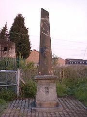
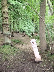
Most posts were made of cast iron and stood at four or five feet tall, but the railway posts were large and impressive obeliskObelisk
An obelisk is a tall, four-sided, narrow tapering monument which ends in a pyramid-like shape at the top, and is said to resemble a petrified ray of the sun-disk. A pair of obelisks usually stood in front of a pylon...
s of granite fourteen feet in height. All bore the City coat of arms. Most of those surviving are painted white, with the arms picked out in red, but the stone ones are often of a sombre black, still bearing the stains accumulated on the smoky trackside. There are five different forms of Coal Tax boundary markers in all. Most of the posts are Grade II listed buildings.
See also
- The London Stone in Staines is very much older but lies on the line of route of the posts
- Close-up image of the shield
- Two posts near Tattenham CornerTattenham CornerTattenham Corner is a small town in Surrey, UK, located inside the M25 motorway thus being part of the London commuter belt. It is home to the Epsom Downs Racecourse. The location is to the west of the A240, with the M25 approximately five miles to the south...

