
Cobbler Creek Recreation Park
Encyclopedia
Adelaide
Adelaide is the capital city of South Australia and the fifth-largest city in Australia. Adelaide has an estimated population of more than 1.2 million...
, South Australia
South Australia
South Australia is a state of Australia in the southern central part of the country. It covers some of the most arid parts of the continent; with a total land area of , it is the fourth largest of Australia's six states and two territories.South Australia shares borders with all of the mainland...
in the suburb of Gulfview Heights
Gulfview Heights, South Australia
Gulfview Heights is a small suburb of Adelaide, South Australia and is within the City of Salisbury and City of Tea Tree Gully local government area. It is adjacent to Wynn Vale, Salisbury East and Para Hills.-History:...
. Originally part of the lands of the Kaurna aboriginal people, it was farmed from European settlement of South Australia until the declaration of the park in 1989.
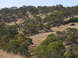
The park provides an open space barrier between Golden Grove and the suburbs of Salisbury, has dams to mitigate flooding and is a significant site for both public recreation and native flora and fauna conservation. It is bounded by main roads and bisected by a four-lane main connecting road.
Structure and climate
Tunnel
A tunnel is an underground passageway, completely enclosed except for openings for egress, commonly at each end.A tunnel may be for foot or vehicular road traffic, for rail traffic, or for a canal. Some tunnels are aqueducts to supply water for consumption or for hydroelectric stations or are sewers...
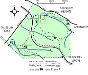
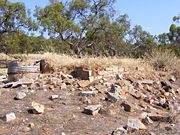
connecting the two park sections. The park is open to the public and includes three formed walking trails and two ruins
Ruins
Ruins are the remains of human-made architecture: structures that were once complete, as time went by, have fallen into a state of partial or complete disrepair, due to lack of maintenance or deliberate acts of destruction...
. The remains of William Pedler's home "Trevalsa" and another's called "Teakles House" lie next to one of the trails. There are no public facilities except for benches, signage and picnic tables. "Kelway House", originally belonging to the Kelway Park farm that occupied much of the park, remains as a National Parks and Wildlife Service
National Parks and Wildlife Service (South Australia)
The National Parks and Wildlife Service is part of the Department for Environment and Heritage - the main government conservation agency in South Australia, Australia....
work centre.
The park lies on the border between the dry northern Adelaide Plains
Adelaide Plains
The Adelaide Plains is the area in South Australia between the Mount Lofty Ranges on the east and Gulf St Vincent on the west. The plains are generally fertile with annual rainfall of about per year....
and the wetter Mount Lofty Ranges
Mount Lofty Ranges
The Mount Lofty Ranges are the range of mountains just to the east of Adelaide in South Australia.-Location and description:The Mount Lofty Ranges stretch from the southernmost point of the Fleurieu Peninsula at Cape Jervis northwards for over before petering out north of Peterborough...
. Based on climate measurements for nearby Parafield Airport
Parafield Airport
Parafield Airport is on the edge of the residential suburb of Parafield, South Australia, 18 kilometres north of the Adelaide Central business district and adjacent to the Mawson Lakes campus of the University of South Australia. It is Adelaide's second airport and the fifth busiest airport in...
, the park has an average rainfall of 465 millimetres (18 in), an average winter daily temperature range of 6.2—15.6 degrees Celsius
Celsius
Celsius is a scale and unit of measurement for temperature. It is named after the Swedish astronomer Anders Celsius , who developed a similar temperature scale two years before his death...
and a summer range of 16.5—29.7. Due to the risk of flooding after heavy rain, the park’s waterways have been dammed
Embankment dam
An embankment dam is a massive artificial water barrier. It is typically created by the emplacement and compaction of a complex semi-plastic mound of various compositions of soil, sand, clay and/or rock. It has a semi-permanent waterproof natural covering for its surface, and a dense, waterproof...
, though they are dry for much of the year. The park’s topography
Topography
Topography is the study of Earth's surface shape and features or those ofplanets, moons, and asteroids...
ranges from steadily sloping in the west, to hilly in the east. Its lowest point, on the western edge along Bridge road, is 70 metres (230 ft) above sea level
Above mean sea level
The term above mean sea level refers to the elevation or altitude of any object, relative to the average sea level datum. AMSL is used extensively in radio by engineers to determine the coverage area a station will be able to reach...
, rising to 215 metres (705 ft) at the Para Trigonometric Point
Benchmark (surveying)
The term bench mark, or benchmark, originates from the chiseled horizontal marks that surveyors made in stone structures, into which an angle-iron could be placed to form a "bench" for a leveling rod, thus ensuring that a leveling rod could be accurately repositioned in the same place in the future...
in the park's southeastern corner. Flat land on the western side has red-brown soil with the remainder having Terra Rosas
Terra rosa (soil)
Terra rossa is a type of red clay soil produced by the weathering of limestone. When limestone weathers, the clay contained in the rocks is left behind, along with any other non-soluble rock material. Under oxidizing conditions, when the soils are above the water table, iron oxide forms in the...
, Redzinas and fine-textured mallee soils.
Cobbler Creek itself begins in the hills to the west of Golden Grove
Golden Grove, South Australia
Golden Grove is an outer north-eastern suburb of Adelaide, South Australia and is within the City of Tea Tree Gully local government area. It is adjacent to Wynn Vale, Surrey Downs, Greenwith, Yatala Vale, Fairview Park, and Salisbury East.- History :...
and joins with Slate Creek prior to entering the park. It is used to collect stormwater
Stormwater
Stormwater is water that originates during precipitation events. It may also be used to apply to water that originates with snowmelt that enters the stormwater system...
from the Tea Tree Gully area as it passes through both farmland and suburbs. After leaving the park the creek passes through housing developments, into wetlands and eventually to the Barker Inlet
Barker Inlet
The Barker Inlet is a tidal inlet of the Gulf St Vincent in Adelaide, South Australia, named after Captain Collet Barker who first sighted it in 1831. It contains one of the southernmost mangrove forests in the world, a dolphin sanctuary, seagrass meadows and is an important fish and shellfish...
.
History
Cornwall
Cornwall is a unitary authority and ceremonial county of England, within the United Kingdom. It is bordered to the north and west by the Celtic Sea, to the south by the English Channel, and to the east by the county of Devon, over the River Tamar. Cornwall has a population of , and covers an area of...
in 1838. He was one of the first to farm the area and from his home made shoes
Shoemaking
Shoemaking is the process of making footwear. Originally, shoes were made one at a time by hand. Traditional handicraft shoemaking has now been largely superseded in volume of shoes produced by industrial mass production of footwear, but not necessarily in quality, attention to detail, or...
and boots for the colony's Governor
Governors of South Australia
The Governor of South Australia is the representative in the Australian state of South Australia of Elizabeth II, Queen of Australia. The Governor performs the same constitutional and ceremonial functions at the state level as does the Governor-General of Australia at the national level.In...
and for teamster
Teamster
A teamster, in modern American English, is a truck driver. The trade union named after them is the International Brotherhood of Teamsters , one of the largest unions in the United States....
s carting ore to Burra
Burra, South Australia
Burra is a pastoral centre and historic tourist town in the mid-north of South Australia. It lies east of the Clare Valley in the Bald Hills range, part of the northern Mount Lofty Ranges, and on Burra Creek. The town began as a single company mining township that, by 1851, was a set of townships ...
. Peddler received a land grant of 66 acres (27 ha) at Cobbler creek in early 1853, later passing the property onto his sons. His profession gave both the creek that passes through the northern part of the park, and the park their names. Pedler's farm occupied the flatter, western area of land near Bridge Road. Much of the park was a farm known as "Kelway Park"; a homestead of the same name remains in the park’s south-west. In the 19th century, Salisbury residents used this area for Sunday school picnic
Picnic
In contemporary usage, a picnic can be defined simply as a pleasure excursion at which a meal is eaten outdoors , ideally taking place in a beautiful landscape such as a park, beside a lake or with an interesting view and possibly at a public event such as before an open air theatre performance,...
s. Swings were temporarily built, water and food brought to the site and games and bands provided for entertainment.
Investigations have found no evidence of land use prior to European settlement, although the park forms part of the traditional lands of the Kaurna aboriginal people. It is likely that the Kaurna used the area during winter for food and shelter, moving to the coast to escape summer heat.
In a 1962 government report, the park’s area was identified for use as future open space. A golf course
Golf course
A golf course comprises a series of holes, each consisting of a teeing ground, fairway, rough and other hazards, and a green with a flagstick and cup, all designed for the game of golf. A standard round of golf consists of playing 18 holes, thus most golf courses have this number of holes...
was proposed, as were other sporting facilities. The course was re-proposed in 1981 and again in the 1990 management plan. The park was purchased by the Government of South Australia
Government of South Australia
The form of the Government of South Australia is prescribed in its constitution, which dates from 1856, although it has been amended many times since then...
in 1970, as part of a program preserving open space for recreation. The park's location was chosen to provide a development-free buffer between the existing suburbs of Salisbury
City of Salisbury
The City of Salisbury is a local government area located on the northern fringes of Adelaide, South Australia. It has an estimated population of 130,022 people and encompasses an area of 158km². The council's main offices are situated in the Salisbury central business district.-Suburbs:-External...
and the proposed Golden Grove
Golden Grove, South Australia
Golden Grove is an outer north-eastern suburb of Adelaide, South Australia and is within the City of Tea Tree Gully local government area. It is adjacent to Wynn Vale, Surrey Downs, Greenwith, Yatala Vale, Fairview Park, and Salisbury East.- History :...
development. It was owned and managed by the State Planning Authority until 1982 when control passed to the National Parks and Wildlife Service. Cobbler Creek was declared a recreation park in 1989, at which point some of the land remained leased for agriculture. The Golden Grove Indenture Act (1984) committed the government to build certain access roads to the new suburb of Golden Grove. Based on the provisions of section 7A-1 in the act, in June 1987 cabinet approved the building of Grove Way. The road is a 4-lane divided connecting road, begun in September 1988 and completed in 1990.
Cobbler Creek Recreation Park is administered and maintained jointly by the City of Salisbury, and the Department for Environment and Heritage. A volunteer group, Friends of Cobbler Creek, was formed in 1990 and works with rangers to improve and maintain the park.
Flora and fauna
Eucalyptus porosa
Eucalyptus porosa, known by the common name of Mallee Box, is a species of eucalypt or gum tree, native to southern Australia.Depending on location, E. porosa can develop into a multi-trunked mallee, or it may develop into a thick, straight, single-trunked tree over 10 metres tall.E. porosa is an...
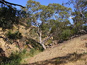
). The park contains some of the last remaining Mallee Box grassy woodland in Adelaide. Amongst the woodlands, plants like the blue-flowering Flax Lily
Dianella (genus)
Dianella is a monocot genus of flowering plants. They are commonly called flax lilies.In the APG II system of plant classification, Dianella was placed in the family Hemerocallidaceae...
are common.
Most of the lower, western parts of the park were cleared for pasture
Pasture
Pasture is land used for grazing. Pasture lands in the narrow sense are enclosed tracts of farmland, grazed by domesticated livestock, such as horses, cattle, sheep or swine. The vegetation of tended pasture, forage, consists mainly of grasses, with an interspersion of legumes and other forbs...
and cropping
Crop (agriculture)
A crop is a non-animal species or variety that is grown to be harvested as food, livestock fodder, fuel or for any other economic purpose. Major world crops include maize , wheat, rice, soybeans, hay, potatoes and cotton. While the term "crop" most commonly refers to plants, it can also include...
until the early 1970s. While there is remnant vegetation on higher ground, introduced pasture grasses and associated weeds dominate much of the understorey. Perennial native grasses, such as kangaroo grass (Themeda triandra
Themeda triandra
Themeda triandra is a perennial grass widespread in Africa, Australia, Asia and the Pacific. In Australia it is commonly known as kangaroo grass, in East and South Africa it is known as "red oat grass" or red grass, in Afrikaans, rooigras.The species has a tuffted habit and can reach up to 1.5 m...
), have been used as part of the park's revegetation. Many of the introduced grasses dry in summer and pose a greater fire hazard than the regrowth. To combat this hazard, and protect surrounding residential areas, annual burns are held particularly around the park's margins. These burns also serve to encourage native vegetation to dominate over introduced weeds.
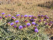
Quandong
Quandong, quandang or quondong, is a common name for the species Santalum acuminatum , especially its edible fruit, but may also refer to* Aceratium concinnum...
, Ruby Saltbush (Enchylaena tormentosa, Desert Cassia (Cassia eremophila), Weeping Pittosporum
Pittosporum
Pittosporum is a genus of about 200 species of flowering plants in the family Pittosporaceae. The genus is probably Gondwanan in origin; its present range extends from Australasia, Oceania, eastern Asia and some parts of Africa. Citriobatus is usually included here, but might be a distinct genus...
and Umbrella Wattle(Acacia ligulata).
Native fauna species have been greatly reduced by past agricultural practices and the introduced rabbit is now common. Eastern Bearded Dragon
Eastern Bearded Dragon
The Eastern bearded dragon is an agamid lizard found in wooded parts of Australia. It is one of a group of species known commonly as Bearded Dragons...
s, White's Skink, Eastern Brown Snake
Eastern brown snake
The eastern brown snake , often referred to as the common brown snake, is a species of genus Pseudonaja. This snake is considered the second most venomous land snake based on its value in mice. It is native to Australia, New Guinea and Indonesia.-Description:Adult eastern brown snakes are highly...
, and Sleepy Lizard reptile species are seen; a total of twenty species have been seen within the park. Black-shouldered Kite
Black-shouldered Kite
The Black-shouldered Kite or Australian Black-shouldered Kite is a small raptor found in open habitat throughout Australia and resembles similar species found in Eurasia and North America, which have in the past also been named as Black-shouldered Kites...
s and Nankeen Kestrel
Nankeen Kestrel
The Australian Kestrel or Nankeen Kestrel is one of the smallest falcons, and unlike many, does not rely on speed to catch its prey. Instead, it simply perches in an exposed position, but it also has a distinctive technique of hovering over crop and grasslands...
s hunt over the grasslands. Red-rumped Parrot
Red-rumped Parrot
The Red-rumped Parrot , also known as the Red-backed Parrot or Grass Parrot, is a common bird of south-eastern Australia, particularly in the Murray-Darling Basin.-Description:...
s and Crested Pigeon
Crested Pigeon
The Crested Pigeon is a bird found widely throughout mainland Australia except for far tropical north areas. It is the only member of the genus Ocyphaps.There are only two Australian pigeon species that possess an erect crest, being the Crested Pigeon and the Spinifex Pigeon...
s are seen feeding on the ground and Wattlebirds, Musk Lorikeet
Musk Lorikeet
The Musk Lorikeet is a lorikeet, one of the three species of the Glossopsitta genus. It inhabits south-central/eastern Australia. The Musk Lorikeet was first described by ornithologist George Shaw in 1790 as Psittacus concinnus, from a collection in the vicinity of Port Jackson in what is now...
s, Noisy Miner
Noisy Miner
The Noisy Miner is a bird common to the eastern and southern states of Australia. It ranges from northern Queensland along the eastern coast to South Australia and Tasmania. Its typical diet consists of nectar, fruit and insects, and occasionally it feeds on small reptiles or amphibians...
s and Honeyeaters in the flowering gums and along creeklines. The park is home to a small population of the worm-like and vulnerable Flinders Ranges Worm-lizard
Flinders Ranges Worm-lizard
The Flinders Ranges Worm-lizard is a species of lizard in the Pygopodidae family.It is endemic to Australia.-Refences:* Australasian Reptile & Amphibian Specialist Group 1996. . Downloaded on 28 July 2007....
(Aprasia pseudopulchella).
Recreation
RecreationRecreation
Recreation is an activity of leisure, leisure being discretionary time. The "need to do something for recreation" is an essential element of human biology and psychology. Recreational activities are often done for enjoyment, amusement, or pleasure and are considered to be "fun"...
al use of the park is encouraged. There are some picnic facilities
Picnic table
A picnic table is a modified table with attached benches, designed for eating a meal outdoors .-Uses:...
provided and dogs are allowed to be walked while on leads. The park includes three named walking trails—Mai Tappa, Babbler and Porosa— that largely follow formed management tracks. The trails pass by the park's ruins and both these and natural sights are highlighted by interpretive signs.
Though mountain bike
Mountain bike
A mountain bike or mountain bicycle is a bicycle created for off-road cycling. This activity includes traversing of rocks and washouts, and steep declines,...
riding is prohibited within the park, illegal trail bike riding is common.
External links
- Alphabetical species list in the park(pdf) (2004, Department for Environment and Heritage)

