
Cofre de Perote
Encyclopedia
Cofre de Perote, originally Naupa-Tecutépetl (from Nāuhpa-Tēuctēpetl in the Nahuatl
language), is known also as Nauhcampatépetl. Both Nahuatl names mean something like 'Place of Four Mountain' or 'Mountain of the Lord of Four Places'. This extinct volcano is located in the Mexican
state of Veracruz
, at the point where the Trans-Mexican volcanic belt
, home to all of Mexico's highest peaks, joins the Sierra Madre Oriental
.
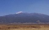
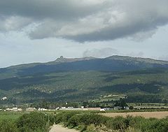
This volcano is shaped very differently from the strato-volcanic Pico de Orizaba
, which lies to the south of it, being broad and shield-shaped. A cofre is a 'coffer
', and the name alludes to a volcanic outcropping like a boss on the shield, which constitutes the peak of the mountain. It is outlined against the clouds in the information-box picture, and is easily visible in the picture below.
To the north of the Cofre is the town of Perote, after which the mountain is named.
Cofre de Perote is also the name of a Mexican national park where the volcano is located.
The Nauhcampatépetl is an excellent place for camping, hiking and other outdoor activities.
Nahuatl
Nahuatl is thought to mean "a good, clear sound" This language name has several spellings, among them náhuatl , Naoatl, Nauatl, Nahuatl, Nawatl. In a back formation from the name of the language, the ethnic group of Nahuatl speakers are called Nahua...
language), is known also as Nauhcampatépetl. Both Nahuatl names mean something like 'Place of Four Mountain' or 'Mountain of the Lord of Four Places'. This extinct volcano is located in the Mexican
Mexico
The United Mexican States , commonly known as Mexico , is a federal constitutional republic in North America. It is bordered on the north by the United States; on the south and west by the Pacific Ocean; on the southeast by Guatemala, Belize, and the Caribbean Sea; and on the east by the Gulf of...
state of Veracruz
Veracruz
Veracruz, formally Veracruz de Ignacio de la Llave officially Estado Libre y Soberano de Veracruz de Ignacio de la Llave , is one of the 31 states that, along with the Federal District, comprise the 32 federative entities of Mexico. It is divided in 212 municipalities and its capital city is...
, at the point where the Trans-Mexican volcanic belt
Trans-Mexican volcanic belt
The Trans-Mexican Volcanic Belt also known as the Transvolcanic Belt and locally as the Sierra Nevada , is a volcanic belt that extends 900 km from west to east across central-southern Mexico...
, home to all of Mexico's highest peaks, joins the Sierra Madre Oriental
Sierra Madre Oriental
The Sierra Madre Oriental is a mountain range in northeastern Mexico.-Setting:Spanning the Sierra Madre Oriental runs from Coahuila south through Nuevo León, southwest Tamaulipas, San Luis Potosí, Querétaro, and Hidalgo to northern Puebla, where it joins with the east-west running Eje Volcánico...
.
This volcano is shaped very differently from the strato-volcanic Pico de Orizaba
Pico de Orizaba
The Pico de Orizaba, or Citlaltépetl , is a stratovolcano, the highest mountain in Mexico and the third highest in North America. It rises above sea level in the eastern end of the Trans-Mexican Volcanic Belt, on the border between the states of Veracruz and Puebla...
, which lies to the south of it, being broad and shield-shaped. A cofre is a 'coffer
Coffer
A coffer in architecture, is a sunken panel in the shape of a square, rectangle, or octagon in a ceiling, soffit or vault...
', and the name alludes to a volcanic outcropping like a boss on the shield, which constitutes the peak of the mountain. It is outlined against the clouds in the information-box picture, and is easily visible in the picture below.
To the north of the Cofre is the town of Perote, after which the mountain is named.
Cofre de Perote is also the name of a Mexican national park where the volcano is located.
The Nauhcampatépetl is an excellent place for camping, hiking and other outdoor activities.
See also
- 4000 meter peaks of México
- 4000 meter peaks of North America
- List of volcanoes in Mexico
- Mountain peaks of MéxicoMountain peaks of MexicoThis article comprises three sortable tables of the major mountain peaks of Mexico.Topographic elevation is the vertical distance above the reference geoid, a precise mathematical model of the Earth's sea level as an equipotential gravitational surface. Topographic prominence is the elevation...
- Mountain peaks of North AmericaMountain peaks of North AmericaThis article comprises three sortable tables of major mountain peaks of greater North America.This article defines greater North America as the portion of the continental landmass of the Americas extending northward from Panama plus the islands surrounding that landmass...