

Columbia Plateau Trail
Encyclopedia
Spokane, Portland and Seattle Railway
The Spokane, Portland and Seattle Railway was a United States-based railroad incorporated in 1905. It was a joint venture by the Great Northern Railway and the Northern Pacific Railway to build a railroad along the north bank of the Columbia River....
. It runs between Cheney, Washington
Cheney, Washington
Cheney is a city in Spokane County, Washington, United States. The full time resident population was 10,590 as of 2010 census. Eastern Washington University is located in Cheney, and its population grows to approximately 17,600 people on a temporary basis when classes at Eastern Washington...
and Pasco
Pasco, Washington
Pasco is a city in and the county seat of Franklin County, Washington, United States.Pasco is one of three cities that make up the Tri-Cities region of the state of Washington...
at the confluence of the Snake River
Snake River
The Snake is a major river of the greater Pacific Northwest in the United States. At long, it is the largest tributary of the Columbia River, the largest North American river that empties into the Pacific Ocean...
and Columbia River
Columbia River
The Columbia River is the largest river in the Pacific Northwest region of North America. The river rises in the Rocky Mountains of British Columbia, Canada, flows northwest and then south into the U.S. state of Washington, then turns west to form most of the border between Washington and the state...
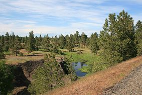
. It passes through parts of five counties in southeastern Washington. It is open to public for recreational use as part of the Washington State Park system. Uses include wildlife viewing, hiking, mountain bicycling, horseback riding and, in paved portions, in-line skating.
Wildlife
Ponderosa Pine
Pinus ponderosa, commonly known as the Ponderosa Pine, Bull Pine, Blackjack Pine, or Western Yellow Pine, is a widespread and variable pine native to western North America. It was first described by David Douglas in 1826, from eastern Washington near present-day Spokane...
/grassland mixed with exposed basalt
Basalt
Basalt is a common extrusive volcanic rock. It is usually grey to black and fine-grained due to rapid cooling of lava at the surface of a planet. It may be porphyritic containing larger crystals in a fine matrix, or vesicular, or frothy scoria. Unweathered basalt is black or grey...
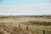
cliffs and areas of meadow and shrub-steppe
Shrub-steppe
Shrub-steppe is a type of low rainfall natural grassland. Shrub-steppes are distinguishable from deserts, which are too dry to support a noticeable cover of perennial grasses or other shrubs, while the shrub-steppe has sufficient moisture levels to support a cover of perennial grasses and/or...
. It bisects the Turnbull National Wildlife Refuge, which encompasses approximately 16000 acres (64.7 km²) of the channeled scablands
Channeled scablands
The Channeled Scablands are a unique geological erosion feature in the U.S. state of Washington. They were created by the cataclysmic Missoula Floods that swept periodically across eastern Washington and down the Columbia River Plateau during the Pleistocene epoch. Geologist J Harlen Bretz coined...
. The numerous erosion-created potholes have formed over 130 marshes, wetlands and lakes which attract a wide range of waterfowl; more than 200 different kinds of birds have been recorded in this area. The Turnbull National Wildlife Refuge was established in 1937 to provide productive breeding and nesting grounds for migratory birds. Other wildlife which inhabit the reserve include elk, mule deer, white-tailed deer, coyotes, badgers, porcupines, muskrats, and beavers.
Geological features
Columbia River Plateau
The Columbia Plateau is a geologic and geographic region that lies across parts of the U.S. states of Washington, Oregon, and Idaho. It is a wide flood basalt plateau between the Cascade Range and the Rocky Mountains, cut through by the Columbia River...
it passed through the unique geological erosion features of the channeled scablands created by the cataclysm
Cataclysm
The term cataclysm The term cataclysm The term cataclysm (from the Greek kataklysmos, to 'wash down' (kluzein "wash" + kata "down") may refer to:*Deluge (mythology)*a hypothetical Doomsday event*any catastrophic geological phenomenon**volcanic eruption**earthquake...
ic Missoula Floods
Missoula Floods
The Missoula Floods refer to the cataclysmic floods that swept periodically across eastern Washington and down the Columbia River Gorge at the end of the last ice age. The glacial flood events have been researched since the 1920s...
that swept periodically across this portion of eastern Washington as well as other parts of the Columbia River Plateau during the Pleistocene epoch
Pleistocene
The Pleistocene is the epoch from 2,588,000 to 11,700 years BP that spans the world's recent period of repeated glaciations. The name pleistocene is derived from the Greek and ....
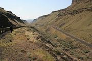
. The trail follows one of the many paths taken by the Missoula Floods as they cut through the Columbia River Basalt
Columbia River Basalt Group
The Columbia River Basalt Group is a large igneous province that lies across parts of the Western United States. It is found in the U.S. states of Washington, Oregon, Idaho, Nevada, and California...
. Notable geologic features which the trail passes include the Cow Creek scabland, the point at which the Palouse River
Palouse River
The Palouse River is a tributary of the Snake River located in the U.S. states of Washington and Idaho. It flows for southwestwards, primarily through the Palouse region of southeastern Washington...
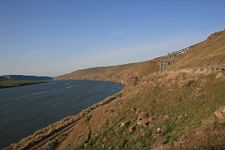
departs its former course (captured by ice-age flood erosion), Washtucna Coulee (the abandoned course of the Palouse River scoured wide by the floods), Devil’s Canyon (a dry straight 4 miles (6.4 km) long former flood channel which descends to the Snake River
Snake River
The Snake is a major river of the greater Pacific Northwest in the United States. At long, it is the largest tributary of the Columbia River, the largest North American river that empties into the Pacific Ocean...
), giant current-created ripples
Giant current ripples
Giant current ripples are active channel topographic forms up to 20 m high, which develop within near-talweg areas of the main outflow valleys crated by glacial lake outburst floods...
formed by the flood currents in the low lands along the Snake River, and the Walker Bar, created by the outflow of the floods.
Access points
- Fishlake trailhead - Milepost 365
- CheneyCheney, WashingtonCheney is a city in Spokane County, Washington, United States. The full time resident population was 10,590 as of 2010 census. Eastern Washington University is located in Cheney, and its population grows to approximately 17,600 people on a temporary basis when classes at Eastern Washington...
Trailhead - Milepost 361.25 - Amber Lake Trailhead - Milestone 349.25
- Martin Road Trailhead - Milestone 342
- LamontLamont, WashingtonLamont is a town in Whitman County, Washington, United States. The population was 70 at the 2010 census.-History:Lamont was named for former vice president of the Northern Pacific Railroad, Daniel Lamont. Lamont was officially incorporated on October 22, 1910.-Historical population:Population...
Trailhead - John Wayne Pioneer TrailJohn Wayne Pioneer TrailThe John Wayne Pioneer Trail follows the former roadbed of the Chicago, Milwaukee, St. Paul and Pacific Railroad for across two-thirds of Washington from the western slopes of the Cascade Mountains to the Idaho border. The Chicago, Milwaukee, St...
intersection (no trailhead) - BengeBenge, WashingtonBenge is an unincorporated community in Adams County, Washington, United States. Because it is not tracked by the U.S. Census, a Census population estimate is not available. Benge is assigned the ZIP code 99105...
Trailhead - WashtucnaWashtucna, WashingtonWashtucna is a town in Adams County, Washington, United States. The population was 208 at the 2010 census, a 20% decrease over the previous census...
Trailhead (Trail Administrative Area in downtown Washtucna) - KahlotusKahlotus, WashingtonKahlotus is a city in Franklin County, Washington, United States. The population was 193 at the 2010 census.-History:The first organized settlement of Kahlotus was by German immigrants, imported by the railroads, in around 1880. Among these settlers were several locally recognized pioneer...
Trailhead & Visitor Center 46°38′41.77"N 118°33′17.67"W - Snake River Junction Trailhood
- Ice Harbor Dam Trailhead 46°14′58"N 118°52′46"W
- Sacajawea State Park PascoPasco, WashingtonPasco is a city in and the county seat of Franklin County, Washington, United States.Pasco is one of three cities that make up the Tri-Cities region of the state of Washington...