Confederation Suburban Centre, Saskatoon
Encyclopedia
| City of Saskatoon Neighbourhoods | |
|---|---|
| Confederation Suburban Centre | |
| Confederation Suburban Development Area | |
 |
|
| Population: | 580 |
| Average Family Income: | $22,873 |
| Average Household Size: | 2.1 |
| Homeownership: | 18.5% |
| Average Home Selling Price: | $67,838 |
| Municipal Ward: | 3 |
| Statistics c2005 | |

Saskatoon
Saskatoon is a city in central Saskatchewan, Canada, on the South Saskatchewan River. Residents of the city of Saskatoon are called Saskatonians. The city is surrounded by the Rural Municipality of Corman Park No. 344....
, Saskatchewan
Saskatchewan
Saskatchewan is a prairie province in Canada, which has an area of . Saskatchewan is bordered on the west by Alberta, on the north by the Northwest Territories, on the east by Manitoba, and on the south by the U.S. states of Montana and North Dakota....
, which consists primarily of commercial development.
Demographics
Confederation Suburban Centre contains Confederation Park Mall, Cosmo Civic Centre, Plaza 22, Carlyle King Library, Fairhaven Bowl and The Real Canadian Superstore. Confederation Suburban Centre has a straight northern boundary that does not follow any roadway, but follows along the edge of the Massey Place Neighborhood around and about Milton Street and a southernmost tip at 11th Street East. It has an eastern boundary along Circle Drive. The western boundary is Diefenbaker Drive between 22nd Street and extends north from here to about Milton Street. The western boundary on the southern portion of 22nd Street encompasses Confederation Inn, and all retail sectors which are east of Fairmount Drive, and north of Fairlight Drive. The western boundary continues along the course of Circle DriveCircle Drive
Circle Drive is a major road constructed as a ring road in Saskatoon, Saskatchewan, Canada. The northeastern portion of the road is part of the Yellowhead Highway.-History:...
until 11th Street taking in the SGI complex, the Jehovah Witness Hall and the Baseball Diamonds and some of W.A. Reid Park.
History
Most of the amenities were constructed between 1970 and 1990. The area was designated a Suburban Centre in the 1980s; prior to this the portion north of 22nd Street was considered part of the Confederation Park community and the area to the south part of Fairhaven.Layout
This area comprises mainly non residential development between the neighboring communities. It makes use of land area on the west side of the major interchange between 22nd Street and Circle Drive.Shopping Malls
The Confederation Suburban Center contains 400 operating businesseswhich is 8% of Saskatoon's retail sector
Plaza 22
Plaza 22 Mall is a strip mallStrip mall
A strip mall is an open-area shopping center where the stores are arranged in a row, with a sidewalk in front. Strip malls are typically developed as a unit and have large parking lots in front...
consisting of a Blockbuster video store, Dollar Store, Fabricland, and a hair salon.
22nd Street Arterial Commercial District
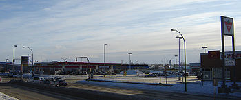
This is a neighborhood of shopping amenities. Several strip malls complement the area and nestle around Canadian TireCanadian Tire
Canadian Tire Corporation, Limited is one of Canada's 60 largest publicly traded companies. The firm operates an inter-related network of businesses engaged in retailing hardgoods, apparel and petroleum as well as financial and automotive services, employing more than 58,000 people across Canada...
, and The Real Canadian Superstore offering a wide variety of goods and services.

Cosmo Civic Centre
- Gymnasium
- RacquetballRacquetballFor other sports often called "paddleball", see Paddleball .Racquetball is a racquet sport played with a hollow rubber ball in an indoor or outdoor court...
and WallyballWallyballWallyball is a fast-paced sport that was created by Bill Dejonghe at The Calabasas Racquetball Club , in 1979 . The idea was an attempt to help bring more business into the club in the summer months The club pro Joe Garcia then took the idea mainstream. However, the sport roots go back to as early...
Court - Fitness Room
- Meeting Rooms
- Theatre
- Combatives Room
- Carlyle King Branch Library
Transportation
22nd Street (Highway 14Saskatchewan Highway 14
Highway 14 is a highway in the Canadian province of Saskatchewan. It runs from the intersection of Idylwyld Drive and 22nd Street in downtown Saskatoon, westward to the Albertan border where it becomes Highway 13. It is approximately 261 km long.Prior to the 1970's, Highway 14 ran the width...
) is a major thoroughfare through Saskatoon Highway 14
Saskatchewan Highway 14
Highway 14 is a highway in the Canadian province of Saskatchewan. It runs from the intersection of Idylwyld Drive and 22nd Street in downtown Saskatoon, westward to the Albertan border where it becomes Highway 13. It is approximately 261 km long.Prior to the 1970's, Highway 14 ran the width...
connects with Asquith
Asquith, Saskatchewan
-External links:*...
, Biggar
Biggar, Saskatchewan
Biggar is a town in central Saskatchewan, Canada. It is located on Highway #14, west of Saskatoon, the province’s most populous city. Biggar has become well known for its unusual town slogan, an Olympic athlete, and a world-record deer...
Wilkie
Wilkie, Saskatchewan
Wilkie is a town in Saskatchewan, Canada located at Section 5, Township 40, Range 19, west of the 3rd Meridian .On February 2, 1907, the first post office was established with the name Glenlogan at Section 4, Township 40, Range 19, west of the 3rd Meridian. The post office changed names on October...
, Unity
Unity, Saskatchewan
-Area statistics:*Lat 52°26′ N*Long 109°10′00″ W*Dominion Land Survey Section 18, Township 40, Range 22, West of the 3rd Meridian*Time zone UTC−6-Location:-See also:*List of towns in Saskatchewan...
, and Macklin en route to Alberta
Alberta
Alberta is a province of Canada. It had an estimated population of 3.7 million in 2010 making it the most populous of Canada's three prairie provinces...
.
City Transit
Saskatoon TransitSaskatoon Transit
Saskatoon Transit is the public transport arm of the City of Saskatoon, Saskatchewan, Canada. It operates a fleet of diesel buses. A total of 23 bus routes serve every area of the city, carrying approximately 11 million passengers in 2008...
Bus Terminal Mall located on the north side of the Confederation Park Parking Lot along Laurier Drive.
- Route 1 Westview/Wildwood
- Route 2 Meadowgreen/8th Street
- Route 3 Riversdale/College Park
- Route 4 Dundonald/Willowgrove
- Route 5 Fairhaven/Briarwood
- Route 22 McCormack Road/City Centre
- Route 23 Blairmore/Hampton Village
- Route 50 Pacific Heights/Lakeview (DART)
- Route 60 Confederation Park/Lakeridge (DART)
| North: Massey Place | ||
| West: Pacific Heights Parkridge Fairhaven | Confederation Suburban Centre | East: Mount Royal Meadowgreen |
| South: Montgomery Place |

