
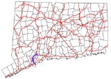
Connecticut Route 108
Encyclopedia
Route 108 in the U.S. state of Connecticut
, also called Huntington Turnpike and Nichols Avenue, is a two-lane state highway
that runs northerly from US 1
, Boston Post Road
in Stratford
, through Trumbull
, to Route 110 in downtown Shelton
. The portion of Nichols Avenue in Trumbull was laid out to the south side of Mischa Hill on December 7, 1696 and is considered, by some, to be the third oldest documented highway in Connecticut after the Mohegan Road (Route 32
) in Norwich
(1670) and the Boston Post Road
or US 1 (1673) .
Lanes and over the town line into Trumbull. Route 108 then makes the climb up Mischa Hill and into Nichols center where it defines the western boundary of the historic Nichols green and intersects with old cross highway Unity Road. Past Nichols center
, it continues northward over Mischa Hill and intersects at a sharp angle with Isinglass Road as it makes its way down into Shelton. It bisects the historic Huntington green separating the common from the old St. Paul's Episcopal Church and old burial ground http://www.stpaulsct.org/index.htm. Route 108 makes a turn eastward past the Huntington green on its way to its terminus at Route 110 in downtown Shelton at the western side of the Housatonic River
.
Route 108 is a two lane road that widens to four lanes with turning lanes and traffic lights at the intersections with Route 8
and Route 15
(Merritt Parkway
) in Trumbull.
Connecticut
Connecticut is a state in the New England region of the northeastern United States. It is bordered by Rhode Island to the east, Massachusetts to the north, and the state of New York to the west and the south .Connecticut is named for the Connecticut River, the major U.S. river that approximately...
, also called Huntington Turnpike and Nichols Avenue, is a two-lane state highway
State highway
State highway, state road or state route can refer to one of three related concepts, two of them related to a state or provincial government in a country that is divided into states or provinces :#A...
that runs northerly from US 1
U.S. Route 1 in Connecticut
In the U.S. state of Connecticut, U.S. Route 1 is a major east–west state highway along Long Island Sound. It has been replaced by Interstate 95 as a through route, which it closely parallels, and now primarily serves as a local business route...
, Boston Post Road
Boston Post Road
The Boston Post Road was a system of mail-delivery routes between New York City and Boston, Massachusetts that evolved into the first major highways in the United States.The three major alignments were the Lower Post Road The Boston Post Road was a system of mail-delivery routes between New York...
in Stratford
Stratford, Connecticut
Stratford is a town in Fairfield County, Connecticut, United States, located on Long Island Sound at the mouth of the Housatonic River. It was founded by Puritans in 1639....
, through Trumbull
Trumbull, Connecticut
Trumbull, a town in Fairfield County, Connecticut in the New England region of the United States, is bordered by the towns of Monroe, Shelton, Stratford, Bridgeport, Fairfield and Easton along Connecticut's Gold Coast. The population was 36,018 according to the 2010 census.Family Circle magazine...
, to Route 110 in downtown Shelton
Shelton, Connecticut
Shelton is a city in Fairfield County, Connecticut, United States. The population was 39,559 at the 2010 census.-Origins:Shelton was settled by the English as part of the town of Stratford, Connecticut, in 1639...
. The portion of Nichols Avenue in Trumbull was laid out to the south side of Mischa Hill on December 7, 1696 and is considered, by some, to be the third oldest documented highway in Connecticut after the Mohegan Road (Route 32
Route 32 (Connecticut)
Route 32 is a primary north–south state highway in the U.S. state of Connecticut, beginning in New London and continuing via Willimantic to the Massachusetts state line, where it continues as Route 32 in that state.-Route description:...
) in Norwich
Norwich, Connecticut
Regular steamship service between New York and Boston helped Norwich to prosper as a shipping center through the early part of the 20th century. During the Civil War, Norwich once again rallied and saw the growth of its textile, armaments, and specialty item manufacturing...
(1670) and the Boston Post Road
Boston Post Road
The Boston Post Road was a system of mail-delivery routes between New York City and Boston, Massachusetts that evolved into the first major highways in the United States.The three major alignments were the Lower Post Road The Boston Post Road was a system of mail-delivery routes between New York...
or US 1 (1673) .
Route description
Route 108 begins at Barnum Avenue or US Route 1 in Stratford. Route 108 proceeds north out of Stratford center intersecting with the old cross highways of North Avenue and Second Hill Lane. It continues northward over the Third Hill and down into a swampy low area intersecting with cross highways Silver and HawleyHawley
-People:* Alan Ramsay Hawley, early American aviator* Cameron Hawley, American fiction writer* Caroline Hawley, BBC war correspondent* David Hawley , Stratfield, Connecticut, captain and privateer during the American Revolution...
Lanes and over the town line into Trumbull. Route 108 then makes the climb up Mischa Hill and into Nichols center where it defines the western boundary of the historic Nichols green and intersects with old cross highway Unity Road. Past Nichols center
Nichols Farms Historic District
According to Stratford land records, Abraham Nichols purchased several old farms and large parcels of land in 1696. Nichols exchanged his land for of Lt. Joseph Judsons old farm which had a barn on it, or half the land owned by Jeremiah Judson, and of land from Benjamin Curtiss...
, it continues northward over Mischa Hill and intersects at a sharp angle with Isinglass Road as it makes its way down into Shelton. It bisects the historic Huntington green separating the common from the old St. Paul's Episcopal Church and old burial ground http://www.stpaulsct.org/index.htm. Route 108 makes a turn eastward past the Huntington green on its way to its terminus at Route 110 in downtown Shelton at the western side of the Housatonic River
Housatonic River
The Housatonic River is a river, approximately long, in western Massachusetts and western Connecticut in the United States. It flows south to southeast, and drains about of southwestern New England into Long Island Sound...
.
Route 108 is a two lane road that widens to four lanes with turning lanes and traffic lights at the intersections with Route 8
Route 8 (Connecticut)
Route 8 is the portion of the multistate New England Route 8 within the state of Connecticut. It is a state highway running north–south from Bridgeport, through Waterbury, all the way to the Massachusetts state line where it continues as Route 8...
and Route 15
Route 15 (Connecticut)
Route 15 is a state highway in the U.S. state of Connecticut that runs from a connection with New York's Hutchinson River Parkway in Greenwich, Connecticut to its northern terminus intersecting with Interstate 84 in East Hartford, Connecticut...
(Merritt Parkway
Merritt Parkway
The Merritt Parkway is a historic limited-access parkway in Fairfield County, Connecticut. The parkway is known for its scenic layout, its uniquely styled signage, and the architecturally elaborate overpasses along the route. It is designated as a National Scenic Byway and is also listed in the...
) in Trumbull.
History
- Originally called the Farm Highway, the portion of current Route 108 through Trumbull, called Nichols Avenue, was designated as a highwayHighwayA highway is any public road. In American English, the term is common and almost always designates major roads. In British English, the term designates any road open to the public. Any interconnected set of highways can be variously referred to as a "highway system", a "highway network", or a...
on December 7, 1696 by the Stratford selectmen . The selectmen recorded into the land records that there is a highway presently running out of the north end of the town, called the farm highway, running northerly into the woods being laid out by the town as far as the brook that runs on the south end of Mischa Hill, the present day intersection of Route 108 and the Merritt Parkway in Trumbull. At the time, the highway was a full 12 rods, or 198 feet (60.4 m) wide at the south side of Mischa Hill, at Zachariah CurtissZachariah Curtiss HouseThe Zachariah Curtiss Houses are located in New England, and are Colonial American wooden post-and-beam timber frame farm houses. The older house of the two was built by Zachariah I around 1686 and the second house was built by his son Zachariah II around 1721 in the Georgian architectural style...
, his land, and at Captain's Farm.
- The Stratford selectmen designed and built a rural highway system of main north–south highways one mile (1.6 km) apart and cross highways one mile (1.6 km) apart. The original north–south highways were Broadbridge Road, Nichols Avenue (now Route 108), Main Street (now Route 113) Huntington Road, Bear Swamp Road or present day Cutspring Road/East Main Street, and River Road (now Route 110). The cross highways were North Avenue, Second Hill Lane, Hawley and Silver Lanes, and Unity Road. On May 18, 1724, the Stratford selectmen voted to extend the highways six miles (10 km) north into the woods or ten miles (16 km) distant from the meeting house. They also voted to build cross highways at mile intervals creating a network of interconnecting highways and dividing the entire north end of the township.
- In October 1725, the General Assembly of the Connecticut ColonyConnecticut ColonyThe Connecticut Colony or Colony of Connecticut was an English colony located in British America that became the U.S. state of Connecticut. Originally known as the River Colony, it was organized on March 3, 1636 as a haven for Puritan noblemen. After early struggles with the Dutch, the English...
referred to the Farm Highway, in their approval of the new Parish of Unity, as Nichol's Farm's Road.
- The northern portion of current Route 108 was part of the Huntington Turnpike, a toll road built by the Huntington Turnpike Company, which was chartered in May 1828. The Huntington Turnpike went from BridgeportBridgeport, ConnecticutBridgeport is the most populous city in the U.S. state of Connecticut. Located in Fairfield County, the city had an estimated population of 144,229 at the 2010 United States Census and is the core of the Greater Bridgeport area...
, through the old town centers of NicholsNichols Farms Historic DistrictAccording to Stratford land records, Abraham Nichols purchased several old farms and large parcels of land in 1696. Nichols exchanged his land for of Lt. Joseph Judsons old farm which had a barn on it, or half the land owned by Jeremiah Judson, and of land from Benjamin Curtiss...
and Huntington (now known as Shelton), to the west bank of the Housatonic RiverHousatonic RiverThe Housatonic River is a river, approximately long, in western Massachusetts and western Connecticut in the United States. It flows south to southeast, and drains about of southwestern New England into Long Island Sound...
opposite Derby Landing (the current downtown area of Shelton). The company was dissolved in March 1886. The southern end of the Huntington Turnpike that did not become part of Route 108 is now an unsigned state road (SR) with designations SR 730 (East Main Street to Route 8) in Bridgeport and SR 711 (Route 8 to Route 108) in Trumbull.
- The modern Route 108 was designated in the 1932 state highway renumbering1932 state highway renumbering (Connecticut)In 1932, the Highway Department of the U.S. state of Connecticut , decided to completely renumber all its state highways. The only exceptions were the U.S. Highways and some of the New England Interstate Routes. Between 1922 and 1932, Connecticut used a state highway numbering system shared with...
, but only between downtown Shelton (the current northern end) and the Huntington green with a length of about 3.4 miles (5.5 km). The designation was extended another 4.4 miles (7.1 km) in 1951 along the Huntington Turnpike to the village of Nichols, ending at then Route 113. It was again extended another 3.2 miles (5.1 km) as a result of the 1962 Route Reclassification Act along Nichols Avenue (former Route 113) to its current southern end at US 1 in Stratford. In 1999, a slight realignment was done in downtown Shelton, gaining an additional 0.1 mile (0.160934 km).
Special designations
- The section of Nichols Avenue from the Stratford-Trumbull town line to the Huntington Turnpike is known as the Trooper Ernest Morse Memorial Highway, named in honor of a state trooperConnecticut State PoliceThe Connecticut State Police is a division of the Connecticut Department of Public Safety responsible for traffic regulation and law enforcement across the state of Connecticut, especially in areas not served by local police departments. The CSP currently has approximately 1,248 troopers, and is...
who was killed trying to apprehend a suspect in a car theft.
Junction list
| Town | Road names | Junction | Milepost | Notes |
|---|---|---|---|---|
| Stratford Stratford, Connecticut Stratford is a town in Fairfield County, Connecticut, United States, located on Long Island Sound at the mouth of the Housatonic River. It was founded by Puritans in 1639.... (2.51 miles) |
Nichols Avenue | 0.00 | ||
| Trumbull Trumbull, Connecticut Trumbull, a town in Fairfield County, Connecticut in the New England region of the United States, is bordered by the towns of Monroe, Shelton, Stratford, Bridgeport, Fairfield and Easton along Connecticut's Gold Coast. The population was 36,018 according to the 2010 census.Family Circle magazine... (2.84 miles) |
Nichols Avenue, Huntington Turnpike | 2.60-2.79 | Exit 8; also provides access to northbound Route 15. | |
| 3.12-3.20 | Partial interchange to southbound Route 15 at Exit 52. | |||
| Shelton Shelton, Connecticut Shelton is a city in Fairfield County, Connecticut, United States. The population was 39,559 at the 2010 census.-Origins:Shelton was settled by the English as part of the town of Stratford, Connecticut, in 1639... (5.70 miles) |
Nichols Ave, Huntington St., Shelton Ave., Wooster St., Coram Ave., Center St. |
11.05 |
On the National Register of Historic Places
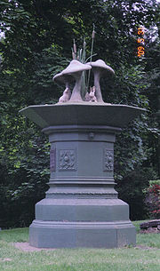
- The Bunny Fountain, as it is called today, is a water fountain donated by the Peet family and dedicated in 1895 for use by human, horse and other four-legged friends, is located on Route 108 at the intersection of Unity Road in the Nichols Farms Historic DistrictNichols Farms Historic DistrictAccording to Stratford land records, Abraham Nichols purchased several old farms and large parcels of land in 1696. Nichols exchanged his land for of Lt. Joseph Judsons old farm which had a barn on it, or half the land owned by Jeremiah Judson, and of land from Benjamin Curtiss...
. - The Curtiss Memorial Fountain, another historic water fountain from the 1800s, was donated by the Curtiss family for public use is located on Route 108 at the northeast end of the historic Huntington green in the Huntington Center Historic District.