
Connecticut Route 59
Encyclopedia
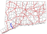
Route 59 is a north–south state highway
in Connecticut
, running from Bridgeport
to Monroe
. Between Bridgeport and Easton
, Route 59 used to be the Stratfield and Weston Turnpike, which operated from 1797 to 1886. Modern Route 59 was designated along the turnpike route in 1932 with a northward extension to the Upper Stepney section of Monroe
.
along Brooklawn Avenue. It runs in a northwest direction, briefly running along the Bridgeport-Fairfield
town line for about 0.3 mile (0.482802 km) before entering Fairfield proper. In Fairfield, the road is known as Stratfield Road and Easton Turnpike. Just south of the Fairfield-Easton
town line, Route 59 crosses over the Merritt Parkway
(at Exit 46). After crossing the Mill River bridge, Route 59 enters the town of Easton and the road name changes to Sport Hill Road. The road continues northwest towards Easton center then turns northeast along Stepney Road at the junction with Route 136. Route 59 ends at Main Street (Route 25
) in the Upper Stepney section of Monroe
near the Monroe Shopping Center.
, which was alternatively known as the Easton Turnpike, was in operation until 1886, when Fairfield County made all its turnpikes free.
By the beginning of the 20th century, the state took over maintenance of most of the major through routes. In 1922, Connecticut began marking its state highways with numbers. By this time, the village of Stratfield had been absorbed into the city of Bridgeport while Easton had become a separate town (since 1845). The Stratfield-Easton route was designated as State Highway 306. In 1932, the state overhauled its highway numbering system
. Most of old Highway 306 was renumbered as part of Route 59. Instead of turning west on Center Street in Easton center, Route 59 continued northwest to meet Westport Road (now Route 136). Westport Road and its continuation, Stepney Road, were both part of another old turnpike, the Branch Turnpike. Route 59 continued northeast along Stepney Road, ending at Route 25 in Upper Stepney. Route 136 was later relocated along the Westport Road section of the Branch Turnpike (in 1963).
State highway
State highway, state road or state route can refer to one of three related concepts, two of them related to a state or provincial government in a country that is divided into states or provinces :#A...
in Connecticut
Connecticut
Connecticut is a state in the New England region of the northeastern United States. It is bordered by Rhode Island to the east, Massachusetts to the north, and the state of New York to the west and the south .Connecticut is named for the Connecticut River, the major U.S. river that approximately...
, running from Bridgeport
Bridgeport, Connecticut
Bridgeport is the most populous city in the U.S. state of Connecticut. Located in Fairfield County, the city had an estimated population of 144,229 at the 2010 United States Census and is the core of the Greater Bridgeport area...
to Monroe
Monroe, Connecticut
Monroe is a town in Fairfield County, Connecticut, United States. The population was 19,479 at the 2010 census. The current first selectman is Steve Vavrek....
. Between Bridgeport and Easton
Easton, Connecticut
Easton is a town in Fairfield County, Connecticut, United States. The population was 7,490 at the 2010 census. Easton contains the historic district of Aspetuck....
, Route 59 used to be the Stratfield and Weston Turnpike, which operated from 1797 to 1886. Modern Route 59 was designated along the turnpike route in 1932 with a northward extension to the Upper Stepney section of Monroe
Monroe, Connecticut
Monroe is a town in Fairfield County, Connecticut, United States. The population was 19,479 at the 2010 census. The current first selectman is Steve Vavrek....
.
Route description
The route begins at North Avenue (US 1) in the Stratfield neighborhood of BridgeportBridgeport
Bridgeport is the most populous city in the U.S. state of Connecticut.Bridgeport may also refer to:-Places:In Canada:* Bridgeport, Nova ScotiaIn the United States:* Bridgeport, Alabama* Bridgeport, California, in Mono County...
along Brooklawn Avenue. It runs in a northwest direction, briefly running along the Bridgeport-Fairfield
Fairfield, Connecticut
Fairfield is a town located in Fairfield County, Connecticut, United States. It is bordered by the towns of Bridgeport, Trumbull, Easton, Redding and Westport along the Gold Coast of Connecticut. As of the 2010 census, the town had a population of 59,404...
town line for about 0.3 mile (0.482802 km) before entering Fairfield proper. In Fairfield, the road is known as Stratfield Road and Easton Turnpike. Just south of the Fairfield-Easton
Easton, Connecticut
Easton is a town in Fairfield County, Connecticut, United States. The population was 7,490 at the 2010 census. Easton contains the historic district of Aspetuck....
town line, Route 59 crosses over the Merritt Parkway
Merritt Parkway
The Merritt Parkway is a historic limited-access parkway in Fairfield County, Connecticut. The parkway is known for its scenic layout, its uniquely styled signage, and the architecturally elaborate overpasses along the route. It is designated as a National Scenic Byway and is also listed in the...
(at Exit 46). After crossing the Mill River bridge, Route 59 enters the town of Easton and the road name changes to Sport Hill Road. The road continues northwest towards Easton center then turns northeast along Stepney Road at the junction with Route 136. Route 59 ends at Main Street (Route 25
Route 25 (Connecticut)
Route 25 is a , primary state highway connecting the city of Bridgeport and the town of Brookfield in the U.S. state of Connecticut. Route 25 is a six-lane freeway from Bridgeport to northern Trumbull and a two-lane surface road the rest of the way to Brookfield.Route 25 was...
) in the Upper Stepney section of Monroe
Monroe, Connecticut
Monroe is a town in Fairfield County, Connecticut, United States. The population was 19,479 at the 2010 census. The current first selectman is Steve Vavrek....
near the Monroe Shopping Center.
History
By the late 18th century, the main road from the village of Stratfield (then in the town of Fairfield) to the village of Easton (then in the town of Weston) had become almost impassable and the repairs were deemed too costly for the towns to shoulder. In 1797, the Stratfield and Weston Turnpike company was chartered with the task of improving the said road and given the privilege of collecting tolls from travellers using the road. The toll road or turnpikeToll road
A toll road is a privately or publicly built road for which a driver pays a toll for use. Structures for which tolls are charged include toll bridges and toll tunnels. Non-toll roads are financed using other sources of revenue, most typically fuel tax or general tax funds...
, which was alternatively known as the Easton Turnpike, was in operation until 1886, when Fairfield County made all its turnpikes free.
By the beginning of the 20th century, the state took over maintenance of most of the major through routes. In 1922, Connecticut began marking its state highways with numbers. By this time, the village of Stratfield had been absorbed into the city of Bridgeport while Easton had become a separate town (since 1845). The Stratfield-Easton route was designated as State Highway 306. In 1932, the state overhauled its highway numbering system
1932 state highway renumbering (Connecticut)
In 1932, the Highway Department of the U.S. state of Connecticut , decided to completely renumber all its state highways. The only exceptions were the U.S. Highways and some of the New England Interstate Routes. Between 1922 and 1932, Connecticut used a state highway numbering system shared with...
. Most of old Highway 306 was renumbered as part of Route 59. Instead of turning west on Center Street in Easton center, Route 59 continued northwest to meet Westport Road (now Route 136). Westport Road and its continuation, Stepney Road, were both part of another old turnpike, the Branch Turnpike. Route 59 continued northeast along Stepney Road, ending at Route 25 in Upper Stepney. Route 136 was later relocated along the Westport Road section of the Branch Turnpike (in 1963).