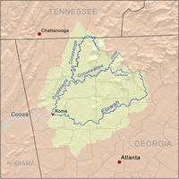
Coosawattee River
Encyclopedia

River
A river is a natural watercourse, usually freshwater, flowing towards an ocean, a lake, a sea, or another river. In a few cases, a river simply flows into the ground or dries up completely before reaching another body of water. Small rivers may also be called by several other names, including...
located in the northwest part of the U.S. state
U.S. state
A U.S. state is any one of the 50 federated states of the United States of America that share sovereignty with the federal government. Because of this shared sovereignty, an American is a citizen both of the federal entity and of his or her state of domicile. Four states use the official title of...
of Georgia
Georgia (U.S. state)
Georgia is a state located in the southeastern United States. It was established in 1732, the last of the original Thirteen Colonies. The state is named after King George II of Great Britain. Georgia was the fourth state to ratify the United States Constitution, on January 2, 1788...
.
The river begins at the confluence
Confluence
Confluence, in geography, describes the meeting of two or more bodies of water.Confluence may also refer to:* Confluence , a property of term rewriting systems...
of the Ellijay River
Ellijay River
The Ellijay River is a river in Georgia. It ends in the town of Ellijay at its confluence with the Cartecay River, forming the Coosawattee River.- References :*USGS Hydrologic Unit Map - State of Georgia...
and Cartecay River
Cartecay River
The Cartecay River is a river that runs through Ellijay, Georgia. It is the site of a class II whitewater run.The Cartecay and Ellijay rivers meet in Ellijay to form the Coosawattee River...
in the city of Ellijay
Ellijay, Georgia
Ellijay is a city in Gilmer County, Georgia, United States. The population was 1,584 at the 2000 census. The city is the county seat of Gilmer County.Ellijay lies where two rivers, the Ellijay and the Cartecay, come together to form the Coosawattee River...
in Gilmer County
Gilmer County, Georgia
Gilmer County is a county located in the U.S. state of Georgia. It was created on December 3, 1832 and was named for George Rockingham Gilmer. As of 2000, the population was 23,456. The 2007 Census Estimate shows a population of 28,389...
. The river flows west through the foothills of the north Georgia mountains
North Georgia mountains
The Georgia Mountains Region or North Georgia mountains or Northeast Georgia is an area that starts in the northeast corner of Georgia, United States, and spreads in a westerly direction. The mountains in this region are in the Blue Ridge mountain chain that ends in Georgia...
.
In Murray County
Murray County, Georgia
Murray County is a county located in the U.S. state of Georgia. As of 2000, the population was 36,506. The 2007 Census Estimate showed a population of 40,664. The county seat is Chatsworth.It is part of the Dalton, Georgia, Metropolitan Statistical Area....
, the river is impounded by Carters Dam
Carters Dam
Carters Dam is an earthen embankment dam located south of Chatsworth in Murray County and west of Ellijay in the U.S. state of Georgia. The dam is 445 ft tall and is situated above the mouth of the Coosawattee River. The drainage area is 376 square miles .The dam took 15 years to build...
, forming Carters Lake
Carters Lake
Carters Lake is classified as one of Georgia's great lakes. Carters Lake is the deepest lake in Georgia and one of the biggest lakes in the state of Georgia. This lake is located in the beautiful Blue Ridge Mountains in both Gilmer and Murray County. It was named after Farrish Carter who lived in...
. The river leaves the dam flowing west, briefly serving as the Murray-Gordon County
Gordon County, Georgia
Gordon County is a county located in the U.S. state of Georgia. As of 2000, the population was 44,104. The 2007 Census Estimate shows a population of 52,044. The county seat is Calhoun.- History :...
line before entering Gordon County. Near New Echota
New Echota
New Echota was the capital of the Cherokee Nation prior to their forced removal in the 1830s. New Echota is 3.68 miles north of present-day Calhoun, Georgia, and south of Resaca, Georgia. The site is a state park and an historic site....
, the Coosawattee meets the Conasauga River
Conasauga River
The Conasauga River is a river that runs through southeast Tennessee and northwest Georgia. The Conasauga River is long and is home to 90 species of fish and 25 species of freshwater mussels...
to form the Oostanaula River
Oostanaula River
The Oostanaula River is a principal tributary of the Coosa River, about long, in northwestern Georgia in the United States. Via the Coosa and Alabama rivers, it is part of the watershed of the Mobile River, which flows to the Gulf of Mexico. Its name is said to come from a Cherokee Indian term...
.
The Coosawattee River is the original river James Dickey
James Dickey
James Lafayette Dickey was an American poet and novelist. He was appointed the eighteenth Poet Laureate Consultant in Poetry to the Library of Congress in 1966.-Early years:...
used as the basis for the "Cahulawassee River" in the novel, Deliverance
Deliverance (novel)
Deliverance is a 1970 novel by James Dickey, his first. It was adapted into a 1972 film by director John Boorman. In 1998, the editors of the Modern Library selected Deliverance as #42 on their list of the 100 best 20th-Century novels...
.

