
.gif)
County Route 115 (Tompkins County, New York)
Encyclopedia
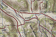
County Route 115 is a northwest–southeast county highway
located mostly within the town of Caroline
in Tompkins County, New York
, United States
. It extends for 12.8 miles (20.6 km) from the Tioga County
line south of the hamlet of Speedsville to an intersection with New York State Route 79 (NY 79) just north of the Caroline town line in the town of Dryden
. The highway continues into Tioga County as CR 33.
The portion of CR 115 north of the hamlet of Guide Board Corners
was originally designated as New York State Route 330 and maintained by the state of New York
. The route existed from the early 1930s to 1980, when ownership and maintenance of the highway was transferred to Tompkins County. Following the swap, the former routing of NY 330 became part of an extended CR 115.
line in the town of Caroline
, where it connects to Tioga County's CR 33. The county highway passes a mountain to the west and the Owego River's west branch to the east as it heads northward. It crosses Boyer Creek as 76 Road and enters the hamlet of Speedsville, a small community located on top of a mountain. Here, CR 115 turns to the northwest to run along the base of a valley surrounding Boyer Creek. The creek reaches its source at an intersection with Yaple Road; however, CR 115 continues northwestward to serve the hamlet of Caroline Center.
Outside of Caroline Center, CR 115 heads northwestward through a small valley to the community of Guide Board Corners
. In the center of the hamlet, CR 115 turns north off 76 Road to follow Central Chapel Road. The highway emerges from the valley 1 miles (1.6 km) north of Guide Board Corners, at which point it meets CR 114, a connector to NY 79
, and curves westward as Valley Road. CR 115 parallels the Sixmile Creek into the hamlet of Brooktondale, where it changes names once more to become Brooktondale Road. From Brooktondale, the route heads northwest alongside Sixmile Creek into the town of Dryden
, where it ends at an intersection with NY 79.
Routes in Tompkins County were initially unsigned; however, Tompkins County recently started posting their county roads with the MUTCD-standard blue pentagon shields.
 In the early 19th century, construction commenced on a highway connecting the Catskill Turnpike (modern NY 79
) to the hamlet of Speedsville near the Tioga County
line. It began at Boiceville (known today as West Slaterville) and passed through the communities of Guide Board Corners
and Caroline Center on its way to Speedsville. The roadway was built by community labor during the summers of 1804 through 1808 and was named "76 Road". According to the Bicentennial history of the Town of Caroline, the name refers to the Revolutionary War
:
 In the early 1910s, the state of New York
upgraded a local highway connecting the Catskill Turnpike near the hamlet of Besemer to Brookton (now Brooktondale). It was added to the state highway system on November 4, 1914. The state also intended on improving an extension of the roadway east to 76 Road and 76 Road itself from the modern junction of Boiceville, Valley, and Central Chapel Roads south to Speedsville; however, construction advanced no farther southeastward than Guide Board Corners. The Brookton – Guide Board Corners highway was added to the state highway system sometime after 1920.
on April 1, 1980, as part of a highway maintenance swap between the two levels of government. As a result, CR 115 was extended northward to NY 79 along NY 330's former routing.
In late June 2006, the Tompkins County Highway Division closed off 76 Road (CR 115) from Central Chapel Road to Caroline Center due to underground damage caused by heavy rains. Vehicular traffic weighing more than 5 short tons (4,535.9 kg) was detoured at Speedsville to follow West Creek Road to NY 79 while traffic weighing less than 5 tons was directed onto Buffalo Hill Road at Caroline Center. The road later reopened.
of CR 115 in the vicinity of Speedsville. It is named Mill Road and connects CR 115 in Speedsville to the Tioga County
line, where it becomes CR 33 and changes names to West Creek Road.
County highway
A county highway is a road in the United States and in the Canadian province of Ontario that is designated and/or maintained by the county highway department...
located mostly within the town of Caroline
Caroline, New York
Caroline is a town in Tompkins County, New York, USA. The population was 2,910 at the 2000 census.The Town of Caroline is on the county's southeast border and is southeast of Ithaca, New York.- History :...
in Tompkins County, New York
Tompkins County, New York
Tompkins County is a county located in the U.S. state of New York, and comprises the whole of the Ithaca metropolitan area. As of the 2010 census, the population was 101,564. The county seat is Ithaca, and the county is home to Cornell University, Ithaca College and Tompkins Cortland Community...
, United States
United States
The United States of America is a federal constitutional republic comprising fifty states and a federal district...
. It extends for 12.8 miles (20.6 km) from the Tioga County
Tioga County, New York
As of the census of 2010, there were 51,125 people residing in the county, with 22,203 housing units, of these 20,350 occupied, 1,853 vacant. The population density was 98 people per square mile...
line south of the hamlet of Speedsville to an intersection with New York State Route 79 (NY 79) just north of the Caroline town line in the town of Dryden
Dryden (town), New York
Dryden is a town in Tompkins County, New York, USA. The population was 13,532 at the 2000 census. The town contains two villages: one also named Dryden and one named Freeville...
. The highway continues into Tioga County as CR 33.
The portion of CR 115 north of the hamlet of Guide Board Corners
Guide Board Corners, New York
Guide Board Corners is a hamlet in the town of Caroline, New York in the United States. The location is situated at the intersection of Central Chapel Road, Grove School Road, and Seventy-Six Road...
was originally designated as New York State Route 330 and maintained by the state of New York
New York
New York is a state in the Northeastern region of the United States. It is the nation's third most populous state. New York is bordered by New Jersey and Pennsylvania to the south, and by Connecticut, Massachusetts and Vermont to the east...
. The route existed from the early 1930s to 1980, when ownership and maintenance of the highway was transferred to Tompkins County. Following the swap, the former routing of NY 330 became part of an extended CR 115.
Route description
CR 115 begins at the Tioga CountyTioga County, New York
As of the census of 2010, there were 51,125 people residing in the county, with 22,203 housing units, of these 20,350 occupied, 1,853 vacant. The population density was 98 people per square mile...
line in the town of Caroline
Caroline, New York
Caroline is a town in Tompkins County, New York, USA. The population was 2,910 at the 2000 census.The Town of Caroline is on the county's southeast border and is southeast of Ithaca, New York.- History :...
, where it connects to Tioga County's CR 33. The county highway passes a mountain to the west and the Owego River's west branch to the east as it heads northward. It crosses Boyer Creek as 76 Road and enters the hamlet of Speedsville, a small community located on top of a mountain. Here, CR 115 turns to the northwest to run along the base of a valley surrounding Boyer Creek. The creek reaches its source at an intersection with Yaple Road; however, CR 115 continues northwestward to serve the hamlet of Caroline Center.
Outside of Caroline Center, CR 115 heads northwestward through a small valley to the community of Guide Board Corners
Guide Board Corners, New York
Guide Board Corners is a hamlet in the town of Caroline, New York in the United States. The location is situated at the intersection of Central Chapel Road, Grove School Road, and Seventy-Six Road...
. In the center of the hamlet, CR 115 turns north off 76 Road to follow Central Chapel Road. The highway emerges from the valley 1 miles (1.6 km) north of Guide Board Corners, at which point it meets CR 114, a connector to NY 79
New York State Route 79
New York State Route 79 is an east–west state highway in the Southern Tier of New York, United States. The western terminus of the route is at the intersection with NY 414 near the southern end of Seneca Lake east of Watkins Glen...
, and curves westward as Valley Road. CR 115 parallels the Sixmile Creek into the hamlet of Brooktondale, where it changes names once more to become Brooktondale Road. From Brooktondale, the route heads northwest alongside Sixmile Creek into the town of Dryden
Dryden (town), New York
Dryden is a town in Tompkins County, New York, USA. The population was 13,532 at the 2000 census. The town contains two villages: one also named Dryden and one named Freeville...
, where it ends at an intersection with NY 79.
Routes in Tompkins County were initially unsigned; however, Tompkins County recently started posting their county roads with the MUTCD-standard blue pentagon shields.
Origins
New York State Route 79
New York State Route 79 is an east–west state highway in the Southern Tier of New York, United States. The western terminus of the route is at the intersection with NY 414 near the southern end of Seneca Lake east of Watkins Glen...
) to the hamlet of Speedsville near the Tioga County
Tioga County, New York
As of the census of 2010, there were 51,125 people residing in the county, with 22,203 housing units, of these 20,350 occupied, 1,853 vacant. The population density was 98 people per square mile...
line. It began at Boiceville (known today as West Slaterville) and passed through the communities of Guide Board Corners
Guide Board Corners, New York
Guide Board Corners is a hamlet in the town of Caroline, New York in the United States. The location is situated at the intersection of Central Chapel Road, Grove School Road, and Seventy-Six Road...
and Caroline Center on its way to Speedsville. The roadway was built by community labor during the summers of 1804 through 1808 and was named "76 Road". According to the Bicentennial history of the Town of Caroline, the name refers to the Revolutionary War
American Revolutionary War
The American Revolutionary War , the American War of Independence, or simply the Revolutionary War, began as a war between the Kingdom of Great Britain and thirteen British colonies in North America, and ended in a global war between several European great powers.The war was the result of the...
:
New York
New York is a state in the Northeastern region of the United States. It is the nation's third most populous state. New York is bordered by New Jersey and Pennsylvania to the south, and by Connecticut, Massachusetts and Vermont to the east...
upgraded a local highway connecting the Catskill Turnpike near the hamlet of Besemer to Brookton (now Brooktondale). It was added to the state highway system on November 4, 1914. The state also intended on improving an extension of the roadway east to 76 Road and 76 Road itself from the modern junction of Boiceville, Valley, and Central Chapel Roads south to Speedsville; however, construction advanced no farther southeastward than Guide Board Corners. The Brookton – Guide Board Corners highway was added to the state highway system sometime after 1920.
Designations and developments
The Besemer – Guide Board Corners state highway was designated as NY 330 ca. 1931. Around the same time, the portion of 76 Road from Speedsville to Guide Board Corners was designated as CR 115. The NY 330 designation was removed on January 24, 1980, and ownership and maintenance of its former routing was transferred from the state of New York to Tompkins CountyTompkins County, New York
Tompkins County is a county located in the U.S. state of New York, and comprises the whole of the Ithaca metropolitan area. As of the 2010 census, the population was 101,564. The county seat is Ithaca, and the county is home to Cornell University, Ithaca College and Tompkins Cortland Community...
on April 1, 1980, as part of a highway maintenance swap between the two levels of government. As a result, CR 115 was extended northward to NY 79 along NY 330's former routing.
In late June 2006, the Tompkins County Highway Division closed off 76 Road (CR 115) from Central Chapel Road to Caroline Center due to underground damage caused by heavy rains. Vehicular traffic weighing more than 5 short tons (4,535.9 kg) was detoured at Speedsville to follow West Creek Road to NY 79 while traffic weighing less than 5 tons was directed onto Buffalo Hill Road at Caroline Center. The road later reopened.
CR 115M
CR 115M is a spur routeSpur route
A spur route is a short road forming a branch from a longer, more important route . A bypass or beltway is never considered a true spur route as it typically reconnects with the major road...
of CR 115 in the vicinity of Speedsville. It is named Mill Road and connects CR 115 in Speedsville to the Tioga County
Tioga County, New York
As of the census of 2010, there were 51,125 people residing in the county, with 22,203 housing units, of these 20,350 occupied, 1,853 vacant. The population density was 98 people per square mile...
line, where it becomes CR 33 and changes names to West Creek Road.