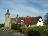
Croxton, Norfolk
Encyclopedia
Croxton is a village and civil parish
in the English county of Norfolk
, north of Thetford
.
It covers an area of 18.96 km² (7.3 sq mi) and had a population of 416 in 176 households as of the 2001 census
. For the purposes of local government, it falls within the district
of Breckland
.
es in Norfolk
. The main structure of the church is estimated to have been built in late AD 1200, most likely by Normans . The first recorded Parish Priest was Simon Peche, in 1316.
Civil parish
In England, a civil parish is a territorial designation and, where they are found, the lowest tier of local government below districts and counties...
in the English county of Norfolk
Norfolk
Norfolk is a low-lying county in the East of England. It has borders with Lincolnshire to the west, Cambridgeshire to the west and southwest and Suffolk to the south. Its northern and eastern boundaries are the North Sea coast and to the north-west the county is bordered by The Wash. The county...
, north of Thetford
Thetford
Thetford is a market town and civil parish in the Breckland district of Norfolk, England. It is on the A11 road between Norwich and London, just south of Thetford Forest. The civil parish, covering an area of , has a population of 21,588.-History:...
.
It covers an area of 18.96 km² (7.3 sq mi) and had a population of 416 in 176 households as of the 2001 census
United Kingdom Census 2001
A nationwide census, known as Census 2001, was conducted in the United Kingdom on Sunday, 29 April 2001. This was the 20th UK Census and recorded a resident population of 58,789,194....
. For the purposes of local government, it falls within the district
Non-metropolitan district
Non-metropolitan districts, or colloquially shire districts, are a type of local government district in England. As created, they are sub-divisions of non-metropolitan counties in a so-called "two-tier" arrangement...
of Breckland
Breckland (district)
Breckland District is a local government district in Norfolk, England. Its council is based in East Dereham.Breckland District derives its name from the Breckland landscape region, a gorse covered sandy heath of south Norfolk and north Suffolk...
.
All Saints Church
The village church, All Saints, is one of 124 existing round-tower churchRound-tower church
Round-tower churches are a type of church found mainly in England, almost solely in East Anglia; of about 185 surviving examples in the country, 124 are in Norfolk, 38 in Suffolk, 6 in Essex, 3 in Sussex and 2 each in Cambridgeshire and Berkshire. There is evidence of about twenty round-tower...
es in Norfolk
Norfolk
Norfolk is a low-lying county in the East of England. It has borders with Lincolnshire to the west, Cambridgeshire to the west and southwest and Suffolk to the south. Its northern and eastern boundaries are the North Sea coast and to the north-west the county is bordered by The Wash. The county...
. The main structure of the church is estimated to have been built in late AD 1200, most likely by Normans . The first recorded Parish Priest was Simon Peche, in 1316.
External links
- Website with photos of Croxton All Saints, a round-tower churchRound-tower churchRound-tower churches are a type of church found mainly in England, almost solely in East Anglia; of about 185 surviving examples in the country, 124 are in Norfolk, 38 in Suffolk, 6 in Essex, 3 in Sussex and 2 each in Cambridgeshire and Berkshire. There is evidence of about twenty round-tower...

