

Cumberland County, New Jersey
Encyclopedia
Cumberland County is a county located in the U.S. state
of New Jersey
. As of the 2010 Census, the population is 156,898. Its county seat
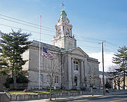
is Bridgeton
. Cumberland County is named for Prince William, Duke of Cumberland.
This county is part of the Delaware Valley
area as well as the Vineland
-Millville
-Bridgeton
Primary Metropolitan Statistical Area.
, the county has a total area of 677 square miles (1,753.4 km²), of which 489 square miles (1,266.5 km²) is land and 187 square miles (484.3 km²) (27.68%) is water.
Cumberland is a low-lying, generally featureless coastal county, with many salt marshes near the Delaware Bay. The highest elevation is at one of 12 areas in Upper Deerfield Township that exceed 140 feet (42.6 m) above sea level; the lowest elevation is sea level.
1across Delaware Bay
; no land border
of 2000, there were 146,438 people, 49,143 households, and 35,186 families residing in the county. The population density
was 299 people per square mile (116/km²). There were 52,863 housing units at an average density of 108 per square mile (42/km²). The racial makeup of the county was 65.88% White
, 20.20% Black
or African American
, 0.97% Native American
, 0.95% Asian
, 0.06% Pacific Islander
, 9.08% from other races
, and 2.85% from two or more races. 19.00% of the population were Hispanic
or Latino
of any race. 17.4% were of Italian
, 9.9% German, 7.9% Irish
and 6.7% English
ancestry according to Census 2000.
There were 49,143 households out of which 34.10% had children under the age of 18 living with them, 48.70% were married couples
living together, 17.30% had a female householder with no husband present, and 28.40% were non-families. 23.60% of all households were made up of individuals and 11.10% had someone living alone who was 65 years of age or older. The average household size was 2.73 and the average family size was 3.19.
In the county the population was spread out with 25.40% under the age of 18, 8.50% from 18 to 24, 31.20% from 25 to 44, 21.90% from 45 to 64, and 13.00% who were 65 years of age or older. The median age was 36 years. For every 100 females there were 104.20 males. For every 100 females age 18 and over, there were 103.50 males.
The median income for a household in the county was $39,150, and the median income for a family was $45,403. Males had a median income of $35,387 versus $25,393 for females. The per capita income
for the county was $17,376. About 11.30% of families and 15.00% of the population were below the poverty line, including 20.10% of those under age 18 and 12.90% of those age 65 or over.
The 2005 demography includes the population as 139,968 people, a slight decrease from 2000. The races were 70.1% White, 16.1% Black or African American, 3.3% Native American/Alaska Native, 1.1% Asian, no Pacific Islanders, 8.0% Other races, 1.1% multiracial and 22.7% Hispanic. Cumberland County has the largest percentage of Native Americans in New Jersey as of the 2005 census.
http://factfinder.census.gov/servlet/ACSSAFFFacts?_event=&geo_id=05000US34011&_geoContext=01000US%7C04000US34%7C05000US34011%7C06000US3401122350&_street=&_county=fairfield+township&_cityTown=fairfield+township&_state=04000US34&_zip=&_lang=en&_sse=on&ActiveGeoDiv=geoSelect&_useEV=&pctxt=fph&pgsl=050&_submenuId=factsheet_1&ds_name=DEC_2000_SAFF&_ci_nbr=null&qr_name=null®=null%3Anull&_keyword=&_industry=]
Asof 2010 the racial makeup of the county was 50.31% Non-Hispanic whites, 20.23% blacks, 1.11% Native Americans, 1.22% Asians, 0.04% Pacific Islanders, 0.14% Non-Hispanics of some other race, 1.87% Non-Hispanics reporting two or more races and 27.06% Hispanic or Latino.
 Cumberland County is governed by a Board of Chosen Freeholders
consisting of seven members. Each Freeholder is assigned responsibility for one of the County's departments. These individuals are elected at large by the citizens of Cumberland County in partisan elections and serve staggered three-year terms in office, with two or three seats coming up for election each year.
, members of the Burlington County Board of Chosen Freeholders (with their term end dates and committee chairmanships listed in parentheses) are Freeholder Director William Whelan (2011; Finance), Deputy Freeholder Director James A. Dunkins (2011; Health), Samuel L. Fiocchi, Sr. (2013; Public Works), Jane Jannarone (2011; Public Affairs, Cultural & History), Carl W. Kirstein (2013; Public Property & Personnel) and Thomas Sheppard (2012; Agriculture).
Freeholder Louis N. Magazzu, whose term was to expire in 2012, announced his resignation on August 2, 2011, after a series of explicit pictures that he had sent to a woman he had known were leaked to a website and published on the Internet. Magazzu apologized to the public and to his family, and announced his resignation immediately.
operates three correctional facilities in the county. They are Bayside State Prison
, South Woods State Prison
, and Southern State Correctional Facility
. In 2007, while the state was preparing to close Riverfront State Prison
in Camden
, it considered establishing a fourth state prison in Cumberland County.
, John Kerry
carried the county by a 6.6% margin over George W. Bush
, with Kerry carrying the state by 6.7% over Bush.
 The following municipalities are located in Cumberland County. The municipality type is listed in parentheses after the name, except where the type is included as part of the name. Census-designated place
s and other unincorporated
communities are listed under their municipalities.
U.S. state
A U.S. state is any one of the 50 federated states of the United States of America that share sovereignty with the federal government. Because of this shared sovereignty, an American is a citizen both of the federal entity and of his or her state of domicile. Four states use the official title of...
of New Jersey
New Jersey
New Jersey is a state in the Northeastern and Middle Atlantic regions of the United States. , its population was 8,791,894. It is bordered on the north and east by the state of New York, on the southeast and south by the Atlantic Ocean, on the west by Pennsylvania and on the southwest by Delaware...
. As of the 2010 Census, the population is 156,898. Its county seat
County seat
A county seat is an administrative center, or seat of government, for a county or civil parish. The term is primarily used in the United States....
is Bridgeton
Bridgeton, New Jersey
Bridgeton is a city in Cumberland County, New Jersey, United States, in the south part of the state, on the Cohansey River, near Delaware Bay. As of the 2010 United States Census, the city population was 25,349. It is the county seat of Cumberland County...
. Cumberland County is named for Prince William, Duke of Cumberland.
This county is part of the Delaware Valley
Delaware Valley
The Delaware Valley is a term used to refer to the valley where the Delaware River flows, along with the surrounding communities. This includes the metropolitan area centered on the city of Philadelphia. Such educational institutions as Delaware Valley Regional High School in Alexandria Township...
area as well as the Vineland
Vineland, New Jersey
Vineland is a city in Cumberland County, New Jersey, United States. As of the 2010 United States Census, the city had a total population of 60,724...
-Millville
Millville, New Jersey
Millville is a city in Cumberland County, New Jersey, United States. As of the 2000 United States Census, the city population was 26,847. Millville, Bridgeton and Vineland are the three principal New Jersey cities of the Vineland-Millville-Bridgeton Primary Metropolitan Statistical Area which...
-Bridgeton
Bridgeton, New Jersey
Bridgeton is a city in Cumberland County, New Jersey, United States, in the south part of the state, on the Cohansey River, near Delaware Bay. As of the 2010 United States Census, the city population was 25,349. It is the county seat of Cumberland County...
Primary Metropolitan Statistical Area.
Geography
According to the U.S. Census BureauUnited States Census Bureau
The United States Census Bureau is the government agency that is responsible for the United States Census. It also gathers other national demographic and economic data...
, the county has a total area of 677 square miles (1,753.4 km²), of which 489 square miles (1,266.5 km²) is land and 187 square miles (484.3 km²) (27.68%) is water.
Cumberland is a low-lying, generally featureless coastal county, with many salt marshes near the Delaware Bay. The highest elevation is at one of 12 areas in Upper Deerfield Township that exceed 140 feet (42.6 m) above sea level; the lowest elevation is sea level.
Adjacent counties
- Gloucester County, New JerseyGloucester County, New JerseyGloucester County is a county located in the U.S. state of New Jersey. As of the 2010 Census, the population was 288,288. Its county seat is Woodbury....
– north - Atlantic County, New JerseyAtlantic County, New Jersey-National protected areas:* Edwin B. Forsythe National Wildlife Refuge * Great Egg Harbor Scenic and Recreational River -Demographics:...
– northeast - Cape May County, New JerseyCape May County, New Jersey-Climate:Being the southernmost point in New Jersey, Cape May has fairly mild wintertime temperatures. Contrary to that, the summertime has lower temperatures than most places in the state, making the county a popular place to escape the heat. It is in zone 7a/7b, which is the same as parts of...
– southeast - Kent County, DelawareKent County, DelawareKent County is a county located in the central part of the U.S. state of Delaware. It is coextensive with the Dover, Delaware, Metropolitan Statistical Area. As of 2010 the population was 162,310, a 28.1% increase over the previous decade. The county seat is Dover, the state capital...
– west1 - Salem County, New JerseySalem County, New Jersey-Demographics:As of the census of 2000, there were 64,285 people, 24,295 households, and 17,370 families residing in the county. The population density was 190 people per square mile . There were 26,158 housing units at an average density of 77 per square mile...
– northwest
1across Delaware Bay
Delaware Bay
Delaware Bay is a major estuary outlet of the Delaware River on the Northeast seaboard of the United States whose fresh water mixes for many miles with the waters of the Atlantic Ocean. It is in area. The bay is bordered by the State of New Jersey and the State of Delaware...
; no land border
Demographics
As of the censusCensus
A census is the procedure of systematically acquiring and recording information about the members of a given population. It is a regularly occurring and official count of a particular population. The term is used mostly in connection with national population and housing censuses; other common...
of 2000, there were 146,438 people, 49,143 households, and 35,186 families residing in the county. The population density
Population density
Population density is a measurement of population per unit area or unit volume. It is frequently applied to living organisms, and particularly to humans...
was 299 people per square mile (116/km²). There were 52,863 housing units at an average density of 108 per square mile (42/km²). The racial makeup of the county was 65.88% White
Race (United States Census)
Race and ethnicity in the United States Census, as defined by the Federal Office of Management and Budget and the United States Census Bureau, are self-identification data items in which residents choose the race or races with which they most closely identify, and indicate whether or not they are...
, 20.20% Black
Race (United States Census)
Race and ethnicity in the United States Census, as defined by the Federal Office of Management and Budget and the United States Census Bureau, are self-identification data items in which residents choose the race or races with which they most closely identify, and indicate whether or not they are...
or African American
Race (United States Census)
Race and ethnicity in the United States Census, as defined by the Federal Office of Management and Budget and the United States Census Bureau, are self-identification data items in which residents choose the race or races with which they most closely identify, and indicate whether or not they are...
, 0.97% Native American
Race (United States Census)
Race and ethnicity in the United States Census, as defined by the Federal Office of Management and Budget and the United States Census Bureau, are self-identification data items in which residents choose the race or races with which they most closely identify, and indicate whether or not they are...
, 0.95% Asian
Race (United States Census)
Race and ethnicity in the United States Census, as defined by the Federal Office of Management and Budget and the United States Census Bureau, are self-identification data items in which residents choose the race or races with which they most closely identify, and indicate whether or not they are...
, 0.06% Pacific Islander
Race (United States Census)
Race and ethnicity in the United States Census, as defined by the Federal Office of Management and Budget and the United States Census Bureau, are self-identification data items in which residents choose the race or races with which they most closely identify, and indicate whether or not they are...
, 9.08% from other races
Race (United States Census)
Race and ethnicity in the United States Census, as defined by the Federal Office of Management and Budget and the United States Census Bureau, are self-identification data items in which residents choose the race or races with which they most closely identify, and indicate whether or not they are...
, and 2.85% from two or more races. 19.00% of the population were Hispanic
Race (United States Census)
Race and ethnicity in the United States Census, as defined by the Federal Office of Management and Budget and the United States Census Bureau, are self-identification data items in which residents choose the race or races with which they most closely identify, and indicate whether or not they are...
or Latino
Race (United States Census)
Race and ethnicity in the United States Census, as defined by the Federal Office of Management and Budget and the United States Census Bureau, are self-identification data items in which residents choose the race or races with which they most closely identify, and indicate whether or not they are...
of any race. 17.4% were of Italian
Italian people
The Italian people are an ethnic group that share a common Italian culture, ancestry and speak the Italian language as a mother tongue. Within Italy, Italians are defined by citizenship, regardless of ancestry or country of residence , and are distinguished from people...
, 9.9% German, 7.9% Irish
Irish people
The Irish people are an ethnic group who originate in Ireland, an island in northwestern Europe. Ireland has been populated for around 9,000 years , with the Irish people's earliest ancestors recorded having legends of being descended from groups such as the Nemedians, Fomorians, Fir Bolg, Tuatha...
and 6.7% English
English people
The English are a nation and ethnic group native to England, who speak English. The English identity is of early mediaeval origin, when they were known in Old English as the Anglecynn. England is now a country of the United Kingdom, and the majority of English people in England are British Citizens...
ancestry according to Census 2000.
There were 49,143 households out of which 34.10% had children under the age of 18 living with them, 48.70% were married couples
Marriage
Marriage is a social union or legal contract between people that creates kinship. It is an institution in which interpersonal relationships, usually intimate and sexual, are acknowledged in a variety of ways, depending on the culture or subculture in which it is found...
living together, 17.30% had a female householder with no husband present, and 28.40% were non-families. 23.60% of all households were made up of individuals and 11.10% had someone living alone who was 65 years of age or older. The average household size was 2.73 and the average family size was 3.19.
In the county the population was spread out with 25.40% under the age of 18, 8.50% from 18 to 24, 31.20% from 25 to 44, 21.90% from 45 to 64, and 13.00% who were 65 years of age or older. The median age was 36 years. For every 100 females there were 104.20 males. For every 100 females age 18 and over, there were 103.50 males.
The median income for a household in the county was $39,150, and the median income for a family was $45,403. Males had a median income of $35,387 versus $25,393 for females. The per capita income
Per capita income
Per capita income or income per person is a measure of mean income within an economic aggregate, such as a country or city. It is calculated by taking a measure of all sources of income in the aggregate and dividing it by the total population...
for the county was $17,376. About 11.30% of families and 15.00% of the population were below the poverty line, including 20.10% of those under age 18 and 12.90% of those age 65 or over.
The 2005 demography includes the population as 139,968 people, a slight decrease from 2000. The races were 70.1% White, 16.1% Black or African American, 3.3% Native American/Alaska Native, 1.1% Asian, no Pacific Islanders, 8.0% Other races, 1.1% multiracial and 22.7% Hispanic. Cumberland County has the largest percentage of Native Americans in New Jersey as of the 2005 census.
http://factfinder.census.gov/servlet/ACSSAFFFacts?_event=&geo_id=05000US34011&_geoContext=01000US%7C04000US34%7C05000US34011%7C06000US3401122350&_street=&_county=fairfield+township&_cityTown=fairfield+township&_state=04000US34&_zip=&_lang=en&_sse=on&ActiveGeoDiv=geoSelect&_useEV=&pctxt=fph&pgsl=050&_submenuId=factsheet_1&ds_name=DEC_2000_SAFF&_ci_nbr=null&qr_name=null®=null%3Anull&_keyword=&_industry=]
Asof 2010 the racial makeup of the county was 50.31% Non-Hispanic whites, 20.23% blacks, 1.11% Native Americans, 1.22% Asians, 0.04% Pacific Islanders, 0.14% Non-Hispanics of some other race, 1.87% Non-Hispanics reporting two or more races and 27.06% Hispanic or Latino.
County government
Board of Chosen Freeholders
In New Jersey, the Boards of Chosen Freeholders are the county legislatures in each of that state's 21 counties.- Origin :New Jersey's system of naming county legislators "freeholders" is unique in the United States...
consisting of seven members. Each Freeholder is assigned responsibility for one of the County's departments. These individuals are elected at large by the citizens of Cumberland County in partisan elections and serve staggered three-year terms in office, with two or three seats coming up for election each year.
, members of the Burlington County Board of Chosen Freeholders (with their term end dates and committee chairmanships listed in parentheses) are Freeholder Director William Whelan (2011; Finance), Deputy Freeholder Director James A. Dunkins (2011; Health), Samuel L. Fiocchi, Sr. (2013; Public Works), Jane Jannarone (2011; Public Affairs, Cultural & History), Carl W. Kirstein (2013; Public Property & Personnel) and Thomas Sheppard (2012; Agriculture).
Freeholder Louis N. Magazzu, whose term was to expire in 2012, announced his resignation on August 2, 2011, after a series of explicit pictures that he had sent to a woman he had known were leaked to a website and published on the Internet. Magazzu apologized to the public and to his family, and announced his resignation immediately.
State representation
The New Jersey Department of CorrectionsNew Jersey Department of Corrections
The New Jersey Department of Corrections is responsible for operations and management of prison facilities in the U.S. state of New Jersey...
operates three correctional facilities in the county. They are Bayside State Prison
Bayside State Prison
Bayside State Prison is a state prison for men located in Leesburg, Maurice River Township, New Jersey. It is of the New Jersey Department of Corrections. It is adjacent to Southern State Correctional Facility....
, South Woods State Prison
South Woods State Prison
South Woods State Prison is a state prison located in Bridgeton, New Jersey for male offenders. It is operated by the New Jersey Department of Corrections.-History:...
, and Southern State Correctional Facility
Southern State Correctional Facility (New Jersey)
Southern State Correctional Facility is a prison for men located in Delmont, Maurice River Township, New Jersey. It is a part of the New Jersey Department of Corrections. It is adjacent to Bayside State Prison....
. In 2007, while the state was preparing to close Riverfront State Prison
Riverfront State Prison
Riverfront State Prison is a former prison in Camden, New Jersey that was operated by the New Jersey Department of Corrections from August 12, 1985 to 2009...
in Camden
Camden, New Jersey
The city of Camden is the county seat of Camden County, New Jersey. It is located across the Delaware River from Philadelphia, Pennsylvania. As of the 2010 United States Census, the city had a total population of 77,344...
, it considered establishing a fourth state prison in Cumberland County.
Politics
In the 2004 U.S. Presidential electionUnited States presidential election, 2004
The United States presidential election of 2004 was the United States' 55th quadrennial presidential election. It was held on Tuesday, November 2, 2004. Republican Party candidate and incumbent President George W. Bush defeated Democratic Party candidate John Kerry, the then-junior U.S. Senator...
, John Kerry
John Kerry
John Forbes Kerry is the senior United States Senator from Massachusetts, the 10th most senior U.S. Senator and chairman of the Senate Foreign Relations Committee. He was the presidential nominee of the Democratic Party in the 2004 presidential election, but lost to former President George W...
carried the county by a 6.6% margin over George W. Bush
George W. Bush
George Walker Bush is an American politician who served as the 43rd President of the United States, from 2001 to 2009. Before that, he was the 46th Governor of Texas, having served from 1995 to 2000....
, with Kerry carrying the state by 6.7% over Bush.
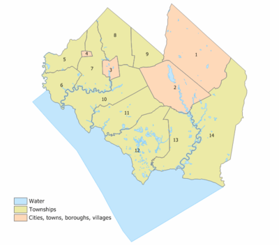
Municipalities
Census-designated place
A census-designated place is a concentration of population identified by the United States Census Bureau for statistical purposes. CDPs are delineated for each decennial census as the statistical counterparts of incorporated places such as cities, towns and villages...
s and other unincorporated
Unincorporated area
In law, an unincorporated area is a region of land that is not a part of any municipality.To "incorporate" in this context means to form a municipal corporation, a city, town, or village with its own government. An unincorporated community is usually not subject to or taxed by a municipal government...
communities are listed under their municipalities.
- BridgetonBridgeton, New JerseyBridgeton is a city in Cumberland County, New Jersey, United States, in the south part of the state, on the Cohansey River, near Delaware Bay. As of the 2010 United States Census, the city population was 25,349. It is the county seat of Cumberland County...
(city) - Commercial TownshipCommercial Township, New JerseyCommercial Township is a township in Cumberland County, New Jersey, United States. It is part of the Vineland-Millville- Bridgeton Primary Metropolitan Statistical Area for statistical purposes...
- Laurel LakeLaurel Lake, New JerseyLaurel Lake is a census-designated place and unincorporated area located within Commercial Township, in Cumberland County, New Jersey. It is part of the Vineland-Millville- Bridgeton Primary Metropolitan Statistical Area for statistical purposes...
- Port NorrisPort Norris, New JerseyPort Norris is a census-designated place and unincorporated area located within Commercial Township, in Cumberland County, New Jersey. It is part of the Vineland-Millville- Bridgeton Primary Metropolitan Statistical Area for statistical purposes...
- Laurel Lake
- Deerfield TownshipDeerfield Township, New JerseyDeerfield Township is a township in Cumberland County, New Jersey, United States. It is part of the Vineland-Milleville-Bridgeton Primary Metropolitan Statistical Area for statistical purposes...
- RosenhaynRosenhayn, New JerseyRosenhayn is a census-designated place and unincorporated area located within Deerfield Township, in Cumberland County, New Jersey. It is part of the Vineland-Milleville- Bridgeton Primary Metropolitan Statistical Area for statistical purposes...
- Rosenhayn
- Downe TownshipDowne Township, New JerseyDowne Township is a township in Cumberland County, New Jersey, United States. It is part of the Vineland-Millville-Bridgeton Primary Metropolitan Statistical Area for statistical purposes...
- Fairfield TownshipFairfield Township, Cumberland County, New JerseyFairfield Township is a township in Cumberland County, New Jersey, United States. It is part of the Vineland-Millville- Bridgeton Primary Metropolitan Statistical Area for statistical purposes...
- FairtonFairton, New JerseyFairton is a census-designated place and unincorporated area located within Fairfield Township, in Cumberland County, New Jersey. It is part of the Vineland-Milleville- Bridgeton Primary Metropolitan Statistical Area for statistical purposes...
- Fairton
- Greenwich TownshipGreenwich Township, Cumberland County, New JerseyGreenwich Township is a township in Cumberland County, New Jersey, United States. It is part of the Vineland-Millville- Bridgeton Primary Metropolitan Statistical Area for statistical purposes...
- Hopewell TownshipHopewell Township, Cumberland County, New JerseyHopewell Township is a township in Cumberland County, New Jersey, in the United States. It is part of the Vineland-Millville- Bridgeton Primary Metropolitan Statistical Area for statistical purposes...
- Lawrence TownshipLawrence Township, Cumberland County, New JerseyLawrence Township is a township in Cumberland County, New Jersey, United States. It is part of the Vineland-Millville-Bridgeton Primary Metropolitan Statistical Area for statistical purposes...
- CedarvilleCedarville, New JerseyCedarville is a census-designated place and unincorporated area located within Lawrence Township, in Cumberland County, New Jersey. It is part of the Vineland-Milleville-Bridgeton Primary Metropolitan Statistical Area for statistical purposes...
- Cedarville
- Maurice River TownshipMaurice River Township, New JerseyMaurice River Township is a township in Cumberland County, New Jersey, United States. It is part of the Vineland-Millville- Bridgeton Primary Metropolitan Statistical Area for statistical purposes...
- MillvilleMillville, New JerseyMillville is a city in Cumberland County, New Jersey, United States. As of the 2000 United States Census, the city population was 26,847. Millville, Bridgeton and Vineland are the three principal New Jersey cities of the Vineland-Millville-Bridgeton Primary Metropolitan Statistical Area which...
(city) - ShilohShiloh, Cumberland County, New JerseyShiloh is a borough in Cumberland County, New Jersey, United States. It is part of the Vineland-Millville- Bridgeton Primary Metropolitan Statistical Area for statistical purposes...
(borough) - Stow Creek TownshipStow Creek Township, New JerseyStow Creek Township is a township in Cumberland County, New Jersey, United States. It is part of the Vineland-Millville-Bridgeton Primary Metropolitan Statistical Area for statistical purposes...
- Upper Deerfield TownshipUpper Deerfield Township, New JerseyUpper Deerfield Township is a township in Cumberland County, New Jersey, United States. It is part of the Vineland-Millville-Bridgeton Primary Metropolitan Statistical Area for statistical purposes...
- Seabrook FarmsSeabrook Farms, New JerseySeabrook Farms is a census-designated place and unincorporated area located within Upper Deerfield Township, in Cumberland County, New Jersey. It is part of the Vineland-Millville- Bridgeton Primary Metropolitan Statistical Area for statistical purposes...
- Seabrook Farms
- VinelandVineland, New JerseyVineland is a city in Cumberland County, New Jersey, United States. As of the 2010 United States Census, the city had a total population of 60,724...
(city)
Airports
The following public-use airports are located in Cumberland County:- Bucks AirportBucks AirportBucks Airport is a privately owned, public-use airport located three nautical miles northeast of the central business district of Bridgeton, a city in Cumberland County, New Jersey, United States.- Facilities and aircraft :...
(00N) in BridgetonBridgeton, New JerseyBridgeton is a city in Cumberland County, New Jersey, United States, in the south part of the state, on the Cohansey River, near Delaware Bay. As of the 2010 United States Census, the city population was 25,349. It is the county seat of Cumberland County... - Li Calzi AirportLi Calzi AirportLi Calzi Airport is a privately owned, public-use airport located two nautical miles south of the central business district of Bridgeton, a city in Cumberland County, New Jersey, United States.- Facilities and aircraft :...
(N50) in BridgetonBridgeton, New JerseyBridgeton is a city in Cumberland County, New Jersey, United States, in the south part of the state, on the Cohansey River, near Delaware Bay. As of the 2010 United States Census, the city population was 25,349. It is the county seat of Cumberland County... - Millville Municipal AirportMillville Municipal AirportMillville Municipal Airport is a public-use airport located three nautical miles southwest of the central business district of Millville, a city in Cumberland County, New Jersey, United States...
(MIV) in MillvilleMillville, New JerseyMillville is a city in Cumberland County, New Jersey, United States. As of the 2000 United States Census, the city population was 26,847. Millville, Bridgeton and Vineland are the three principal New Jersey cities of the Vineland-Millville-Bridgeton Primary Metropolitan Statistical Area which... - Kroelinger AirportKroelinger AirportKroelinger Airport is a privately owned, public-use airport in Cumberland County, New Jersey, United States. It is located three nautical miles north of the central business district of Vineland.- Facilities and aircraft :...
(29N) in VinelandVineland, New JerseyVineland is a city in Cumberland County, New Jersey, United States. As of the 2010 United States Census, the city had a total population of 60,724...