
Curecanti Needle
Encyclopedia
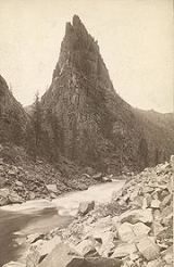
The Curecanti Needle is a distinct granite
rock formation near Curicante, Colorado
. Rising approximately 215 m or 700 ft from the canyon floor, with its pointy shape and being situated on the shore of the former Gunnison River
it is one of the landmarks of the Colorado Rocky Mountains.
Until 1882, its location remained remote to most human beings but the arrival of the Denver & Rio Grande Western Railroad mainlines through the canyon significantly changed this. The train ride along the Gunnison River greatly contributed to the railway earning a reputation as one of many scenic views. The Curecanti Needle in particular featured as an example of the beautiful surroundings of the railroads lines during 1887 to 1926 as it appeared in drawn logos of the railroad company.
Today the rock does not appear quite as prominent as before since the Gunnison River water level has risen and converted into Morrow Point Lake. The lake is in effect the dam reservoir after the completion of the Crystal Dam
about 10 kilometres (6.2 mi) down stream in 1976.
Granite
Granite is a common and widely occurring type of intrusive, felsic, igneous rock. Granite usually has a medium- to coarse-grained texture. Occasionally some individual crystals are larger than the groundmass, in which case the texture is known as porphyritic. A granitic rock with a porphyritic...
rock formation near Curicante, Colorado
Colorado
Colorado is a U.S. state that encompasses much of the Rocky Mountains as well as the northeastern portion of the Colorado Plateau and the western edge of the Great Plains...
. Rising approximately 215 m or 700 ft from the canyon floor, with its pointy shape and being situated on the shore of the former Gunnison River
Gunnison River
The Gunnison River is a tributary of the Colorado River, long, in the Southwest state of Colorado. It is the fifth largest tributary of the Colorado River, with a mean flow of 4320 ft³/s .-Description:...
it is one of the landmarks of the Colorado Rocky Mountains.
Until 1882, its location remained remote to most human beings but the arrival of the Denver & Rio Grande Western Railroad mainlines through the canyon significantly changed this. The train ride along the Gunnison River greatly contributed to the railway earning a reputation as one of many scenic views. The Curecanti Needle in particular featured as an example of the beautiful surroundings of the railroads lines during 1887 to 1926 as it appeared in drawn logos of the railroad company.
Today the rock does not appear quite as prominent as before since the Gunnison River water level has risen and converted into Morrow Point Lake. The lake is in effect the dam reservoir after the completion of the Crystal Dam
Crystal Dam
Crystal Dam is a double curvature, concrete thin arch dam located six miles downstream from Morrow Point Dam on the Gunnison River in Colorado, USA. Crystal Dam is the newest of the three dams in Curecanti National Recreation Area; construction on the dam was finished in 1976. The dam impounds...
about 10 kilometres (6.2 mi) down stream in 1976.
External links
- Curecanti National Recreation Area - National Parks Service