
Cyclone Daman
Encyclopedia
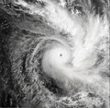
Severe Tropical Cyclone Daman (RSMC Nadi designation 04F, JTWC designation 05P) was the strongest cyclone of the 2007–08 South Pacific cyclone season
. Cyclone Daman was the fourth tropical depression and the first severe tropical cyclone to form west of longitude
160°E
during the 2007–08 South Pacific cyclone season
. Due to the severity of the storm, the name Daman was retired and replaced with Denia.
On December 3, the Regional Specialized Meteorological Centre
(RSMC) in Nadi, Fiji, upgraded a tropical disturbance, located to the west of the Solomon Islands
, to Tropical Depression 04F. On December 5, as the depression moved towards the west into the Fijian archipelago
, both the Joint Typhoon Warning Center
(JTWC) and RSMC Nadi upgraded it to Cyclone Daman. On December 7 the cyclone reached its peak intensity with winds of 185 km/h, (115 mph 10-minute sustained) which made Daman a Category 4 cyclone on the Australian Tropical Cyclone Intensity Scale. Later that day Daman also reached its peak intensity by 1-minute means with winds of 205 km/h (125 mph) which made it a Category 3 tropical cyclone on the Saffir-Simpson Hurricane Scale
. Early on December 8, Cyclone Daman brushed by the Fijian island of Cikobia, causing damage to housing, crops and vegetation. Daman then weakened the next day into a tropical depression and dissipated on December 10.
 Late on December 2, the Joint Typhoon Warning Center
(JTWC) started to monitor an area of disturbed weather that was located within the South Pacific convergence zone
to the northwest of Apia, Samoa
. Located beneath an anticyclone, the system maintained deep convection near its elongated but well-defined circulation center. Early the next day, the Regional Specialized Meteorological Center
in Nadi, Fiji, (RSMC Nadi), started to monitor the area of disturbed weather as Tropical Depression 04F. Over the next two days, the depression moved towards the west, conditions surrounding the depression barely changed and as a result the depression steadily intensified. Early on December 5, the system had convective bands spiraling into and wrapping tightly around the low level circulation center. As a result of this, the JTWC started advisories on Tropical Cyclone 05P, with winds equivalent to a tropical storm. At 0200 UTC, RSMC Nadi reported that the tropical depression had intensified into a category one tropical cyclone on the Australian tropical cyclone intensity scale and named it as Daman. During that day Daman passed over Rotuma island while gradually intensifying further.
At 0600 UTC, on December 6, the JTWC reported that Daman had intensified into a category one tropical cyclone on the Saffir-Simpson Hurricane scale
. Shortly after this, the cyclone made an abrupt turn and started to move towards the east instead of moving towards the south. Later that day at 1200 UTC, RSMC Nadi reported that Daman had intensified into a category three severe tropical cyclone as it was now sporting a cloud filled eye
. The cyclone continued to intensify over the next 12 hours becoming a category four severe tropical cyclone at 0000 UTC on December 7. At that time RSMC Nadi forecasted, that there was a possibility that Daman could become a category five severe tropical cyclone, with windspeeds of 215 km/h, (130 mph), within 12 hours. However six hours later as the general organization of the eye had weakened, RSMC Nadi reported that the cyclone had peaked as a category four severe tropical cyclone with ten minute winds of 195 km/h, (120 mph) and a peak pressure of 925 hPa (27.3 inHg). The JTWC also reported that Cyclone Daman had peaked with one minute winds of 195 km/h, (120 mph). In their post storm analysis, both RSMC Nadi and the JTWC revised their estimated peak windspeeds, with RSMC Nadi lowering their estimated windspeeds to 185 km/h, (115 mph), while the JTWC elevated their estimates to 205 km/h, (125 mph). As the Cyclone peaked in intensity, it started to accelerate towards the southeast and passed over or close to Thikombia island, before becoming under the influence of a mid-level ridge of high pressure
. As it came under the influence of the mid-level ridge of high pressure, Daman turned once more and started to move slowly towards the southeast, into an area of strengthening vertical windshear and cooler sea surface temperatures. As a result Daman rapidly weakened during December 8, before both the next day as the system moved through the Lau Islands
, both the JTWC and RSMC Nadi reported that it had weakened into a tropical depression. The final advisories on the system were issued the next day as Daman merged with a frontal system.
had been issued for the Fijian dependency of Rotuma
. Later that morning, as the Cyclone moved over Rotuma, RSMC Nadi issued a tropical cyclone alert for the rest of Fiji. During that afternoon, RSMC Nadi canceled the tropical cyclone gale warning for Rotuma and then upgraded the cyclone alerts for the northwest of Fiji to a tropical cyclone gale warning later that day. Early the next day, as the storm was intensifying, they upgraded the gale warnings for parts of northwest of Fiji to storm warning
s while expanding the warnings to the western and central sides of Viti Levu
and the western side of Vanua Levu
. During that afternoon RSMC Nadi further revised the warnings as Cyclone Daman had become a severe tropical cyclone.
A hurricane warning was then declared at this time for the Yasawa Group, northern Viti Levu
, Vanua Levu
as well as smaller islands located nearby. Later that day, as Daman reached its peak, all areas of Fiji were under a gale warning. Early on December 7 RSMC Nadi canceled some of the warnings for Fiji, including the gale force warning for southwestern Viti Levu, and then later that day downgraded all the warnings that were still in effect for Fiji to gale force as Daman was weakening. Early the next day RSMC Nadi declared a tropical cyclone alert for the central and southern islands of Tonga
, however, as new observations had become available which indicated that the cyclone was weakening at a faster rate then originally thought and was no longer a threat to Tonga
. The next day RSMC Nadi canceled all tropical cyclone warnings and alerts
as they issued their last special weather bulletin on the cyclone as Daman had weakened into a tropical depression.
Cyclone Daman brought heavy rain which caused floods and landslides within Fiji's northern division. This led to several international and domestic flights being canceled on December 7. The Fijian island of Cikobia received a direct hit whilst Daman passed directly over Rotuma
. The total cost to Fiji
from Cyclone Daman was
F$
500,000 (2007) ($330,000 US$ 2007) with no damage being reported in Tonga from the storm.
Daman did most of its damages on Cikobia island, which has a population of around 120. Damage on Cikobia included extensive damages to houses, school buildings, crops, fruitbearing trees and foliage. Water pipes were damaged by fallen trees as a result of high winds from the storm. Despite initial fears of there being some fatalities on Cikobia, no loss of life was recorded due to the storm. This was because the islands 120 residents had evacuated to caves on Cikobia. The Fijian Dependency of Rotuma experienced a significant amount of rainfall from December 5 until December 7, when Cyclone Daman was located near Rotuma.
Because there were no deaths and only 65 people had been directly affected by Cyclone Daman, the Fiji
an government, with the help of the Red Cross, decided not to request any International Aid or any external assistance. The Fijian Government, on January 15, 2008, allocated $530,000 2008 FJD for the relief and rehabilitation programme of Cikobia. By August 2008, all work rebuilding Cikobia after Cyclone Daman had been completed.
(mbar), was the strongest storm within the 2007–08 South Pacific season, as well as the most intense storm during 2007 that RSMC Nadi had monitored in the south Pacific that season.
This was the third time that the name Daman had been used to name a cyclone in the south Pacific, having last been used in the 1991-1992 season. After this season the name Daman was retired and replaced with the name Denia, after a request from the representative of Fiji, at the World Meteorological Organization's RA V Tropical Cyclone Committee.
2007–08 South Pacific cyclone season
The 2007–08 South Pacific cyclone season was one of the least active tropical cyclone seasons on record, with only four tropical cyclones occurring within the South Pacific Ocean to the east of 160°E. The season officially ran from November 1, 2007 until April 30, 2008, although the first cyclone,...
. Cyclone Daman was the fourth tropical depression and the first severe tropical cyclone to form west of longitude
Longitude
Longitude is a geographic coordinate that specifies the east-west position of a point on the Earth's surface. It is an angular measurement, usually expressed in degrees, minutes and seconds, and denoted by the Greek letter lambda ....
160°E
160th meridian east
The meridian 160° east of Greenwich is a line of longitude that extends from the North Pole across the Arctic Ocean, Asia, the Pacific Ocean, the Southern Ocean, and Antarctica to the South Pole....
during the 2007–08 South Pacific cyclone season
2007–08 South Pacific cyclone season
The 2007–08 South Pacific cyclone season was one of the least active tropical cyclone seasons on record, with only four tropical cyclones occurring within the South Pacific Ocean to the east of 160°E. The season officially ran from November 1, 2007 until April 30, 2008, although the first cyclone,...
. Due to the severity of the storm, the name Daman was retired and replaced with Denia.
On December 3, the Regional Specialized Meteorological Centre
Regional Specialized Meteorological Centre
A Regional Specialized Meteorological Centre is responsible for the distribution of information, advisories, and warnings regarding the specific program they have a part of, agreed by consensus at the World Meteorological Organization as part of the World Weather Watch.-Tropical...
(RSMC) in Nadi, Fiji, upgraded a tropical disturbance, located to the west of the Solomon Islands
Solomon Islands
Solomon Islands is a sovereign state in Oceania, east of Papua New Guinea, consisting of nearly one thousand islands. It covers a land mass of . The capital, Honiara, is located on the island of Guadalcanal...
, to Tropical Depression 04F. On December 5, as the depression moved towards the west into the Fijian archipelago
Fiji
Fiji , officially the Republic of Fiji , is an island nation in Melanesia in the South Pacific Ocean about northeast of New Zealand's North Island...
, both the Joint Typhoon Warning Center
Joint Typhoon Warning Center
The Joint Typhoon Warning Center is a joint United States Navy – United States Air Force task force located at the Naval Maritime Forecast Center in Pearl Harbor, Hawaii...
(JTWC) and RSMC Nadi upgraded it to Cyclone Daman. On December 7 the cyclone reached its peak intensity with winds of 185 km/h, (115 mph 10-minute sustained) which made Daman a Category 4 cyclone on the Australian Tropical Cyclone Intensity Scale. Later that day Daman also reached its peak intensity by 1-minute means with winds of 205 km/h (125 mph) which made it a Category 3 tropical cyclone on the Saffir-Simpson Hurricane Scale
Saffir-Simpson Hurricane Scale
The Saffir–Simpson Hurricane Scale , or the Saffir–Simpson Hurricane Wind Scale , classifies hurricanes — Western Hemisphere tropical cyclones that exceed the intensities of tropical depressions and tropical storms — into five categories distinguished by the intensities of their sustained winds...
. Early on December 8, Cyclone Daman brushed by the Fijian island of Cikobia, causing damage to housing, crops and vegetation. Daman then weakened the next day into a tropical depression and dissipated on December 10.
Meteorological history
Joint Typhoon Warning Center
The Joint Typhoon Warning Center is a joint United States Navy – United States Air Force task force located at the Naval Maritime Forecast Center in Pearl Harbor, Hawaii...
(JTWC) started to monitor an area of disturbed weather that was located within the South Pacific convergence zone
South Pacific convergence zone
The South Pacific Convergence Zone , a reverse-oriented monsoon trough, is a band of low-level convergence, cloudiness and precipitation extending from the west Pacific warm pool south-eastwards towards French Polynesia...
to the northwest of Apia, Samoa
Apia, Samoa
-Administration:Apia is part of the Tuamasaga political district and of election district Vaimauga West and Faleata East. There is no city administration for Apia. Apia consists of some 45 individual, independent villages...
. Located beneath an anticyclone, the system maintained deep convection near its elongated but well-defined circulation center. Early the next day, the Regional Specialized Meteorological Center
Regional Specialized Meteorological Center
A Regional Specialized Meteorological Centre is responsible for the distribution of information, advisories, and warnings regarding the specific program they have a part of, agreed by consensus at the World Meteorological Organization as part of the World Weather Watch.-Tropical...
in Nadi, Fiji, (RSMC Nadi), started to monitor the area of disturbed weather as Tropical Depression 04F. Over the next two days, the depression moved towards the west, conditions surrounding the depression barely changed and as a result the depression steadily intensified. Early on December 5, the system had convective bands spiraling into and wrapping tightly around the low level circulation center. As a result of this, the JTWC started advisories on Tropical Cyclone 05P, with winds equivalent to a tropical storm. At 0200 UTC, RSMC Nadi reported that the tropical depression had intensified into a category one tropical cyclone on the Australian tropical cyclone intensity scale and named it as Daman. During that day Daman passed over Rotuma island while gradually intensifying further.
At 0600 UTC, on December 6, the JTWC reported that Daman had intensified into a category one tropical cyclone on the Saffir-Simpson Hurricane scale
Saffir-Simpson Hurricane Scale
The Saffir–Simpson Hurricane Scale , or the Saffir–Simpson Hurricane Wind Scale , classifies hurricanes — Western Hemisphere tropical cyclones that exceed the intensities of tropical depressions and tropical storms — into five categories distinguished by the intensities of their sustained winds...
. Shortly after this, the cyclone made an abrupt turn and started to move towards the east instead of moving towards the south. Later that day at 1200 UTC, RSMC Nadi reported that Daman had intensified into a category three severe tropical cyclone as it was now sporting a cloud filled eye
Eye (cyclone)
The eye is a region of mostly calm weather found at the center of strong tropical cyclones. The eye of a storm is a roughly circular area and typically 30–65 km in diameter. It is surrounded by the eyewall, a ring of towering thunderstorms where the second most severe weather of a cyclone...
. The cyclone continued to intensify over the next 12 hours becoming a category four severe tropical cyclone at 0000 UTC on December 7. At that time RSMC Nadi forecasted, that there was a possibility that Daman could become a category five severe tropical cyclone, with windspeeds of 215 km/h, (130 mph), within 12 hours. However six hours later as the general organization of the eye had weakened, RSMC Nadi reported that the cyclone had peaked as a category four severe tropical cyclone with ten minute winds of 195 km/h, (120 mph) and a peak pressure of 925 hPa (27.3 inHg). The JTWC also reported that Cyclone Daman had peaked with one minute winds of 195 km/h, (120 mph). In their post storm analysis, both RSMC Nadi and the JTWC revised their estimated peak windspeeds, with RSMC Nadi lowering their estimated windspeeds to 185 km/h, (115 mph), while the JTWC elevated their estimates to 205 km/h, (125 mph). As the Cyclone peaked in intensity, it started to accelerate towards the southeast and passed over or close to Thikombia island, before becoming under the influence of a mid-level ridge of high pressure
High pressure
High pressure in science and engineering is studying the effects of high pressure on materials and the design and construction of devices, such as a diamond anvil cell, which can create high pressure...
. As it came under the influence of the mid-level ridge of high pressure, Daman turned once more and started to move slowly towards the southeast, into an area of strengthening vertical windshear and cooler sea surface temperatures. As a result Daman rapidly weakened during December 8, before both the next day as the system moved through the Lau Islands
Lau Islands
The Lau Islands of Fiji are situated in the southern Pacific Ocean, just east of the Koro Sea. Of this chain of about one hundred islands and islets, about thirty are inhabited...
, both the JTWC and RSMC Nadi reported that it had weakened into a tropical depression. The final advisories on the system were issued the next day as Daman merged with a frontal system.
Preparations
Early on December 5, RSMC Nadi started to issue special weather bulletins on Cyclone Daman as a tropical cyclone gale warningGale warning
A gale warning is a warning issued by weather services in maritime locations about the existence of winds of gale force or above or the imminent occurrence of gales at sea...
had been issued for the Fijian dependency of Rotuma
Rotuma
Rotuma is a Fijian dependency, consisting of Rotuma Island and nearby islets. The island group is home to a small but unique indigenous ethnic group which constitutes a recognizable minority within the population of Fiji, known as "Rotumans"...
. Later that morning, as the Cyclone moved over Rotuma, RSMC Nadi issued a tropical cyclone alert for the rest of Fiji. During that afternoon, RSMC Nadi canceled the tropical cyclone gale warning for Rotuma and then upgraded the cyclone alerts for the northwest of Fiji to a tropical cyclone gale warning later that day. Early the next day, as the storm was intensifying, they upgraded the gale warnings for parts of northwest of Fiji to storm warning
Storm warning
At sea, a storm warning is a warning issued by the National Weather Service of the United States when winds between 48 knots and 63 knots are occurring or predicted to occur soon. The winds must not be associated with a tropical cyclone...
s while expanding the warnings to the western and central sides of Viti Levu
Viti Levu
Viti Levu is the largest island in the Republic of Fiji, the site of the nation's capital, Suva, and home to a large majority of Fiji's population.- Geography and economy :...
and the western side of Vanua Levu
Vanua Levu
Vanua Levu , formerly known as Sandalwood Island, is the second largest island of Fiji. Located 64 kilometres to the north of the larger Viti Levu, the island has an area of 5,587.1 km² and a population of some 130,000.- Geography :...
. During that afternoon RSMC Nadi further revised the warnings as Cyclone Daman had become a severe tropical cyclone.
A hurricane warning was then declared at this time for the Yasawa Group, northern Viti Levu
Viti Levu
Viti Levu is the largest island in the Republic of Fiji, the site of the nation's capital, Suva, and home to a large majority of Fiji's population.- Geography and economy :...
, Vanua Levu
Vanua Levu
Vanua Levu , formerly known as Sandalwood Island, is the second largest island of Fiji. Located 64 kilometres to the north of the larger Viti Levu, the island has an area of 5,587.1 km² and a population of some 130,000.- Geography :...
as well as smaller islands located nearby. Later that day, as Daman reached its peak, all areas of Fiji were under a gale warning. Early on December 7 RSMC Nadi canceled some of the warnings for Fiji, including the gale force warning for southwestern Viti Levu, and then later that day downgraded all the warnings that were still in effect for Fiji to gale force as Daman was weakening. Early the next day RSMC Nadi declared a tropical cyclone alert for the central and southern islands of Tonga
Tonga
Tonga, officially the Kingdom of Tonga , is a state and an archipelago in the South Pacific Ocean, comprising 176 islands scattered over of ocean in the South Pacific...
, however, as new observations had become available which indicated that the cyclone was weakening at a faster rate then originally thought and was no longer a threat to Tonga
Tonga
Tonga, officially the Kingdom of Tonga , is a state and an archipelago in the South Pacific Ocean, comprising 176 islands scattered over of ocean in the South Pacific...
. The next day RSMC Nadi canceled all tropical cyclone warnings and alerts
Tropical cyclone warnings and watches
Warnings and watches are two levels of alert issued by national weather forecasting bodies to coastal areas threatened by the imminent approach of a tropical cyclone of tropical storm or hurricane intensity. They are notices to the local population and civil authorities to make appropriate...
as they issued their last special weather bulletin on the cyclone as Daman had weakened into a tropical depression.
Impact and aftermath
| Cyclone Name | Minimum Pressure | |
|---|---|---|
| 1 | Daman | 925 hPa HPA -Organizations:*Halifax Port Authority, a port authority in Canada*Hamburg Port Authority, the port authority for the Port of Hamburg, Germany*Health Protection Agency, a health organization in the United Kingdom... /mbar |
| 2 | Funa | 930 hPa HPA -Organizations:*Halifax Port Authority, a port authority in Canada*Hamburg Port Authority, the port authority for the Port of Hamburg, Germany*Health Protection Agency, a health organization in the United Kingdom... /mbar |
| 3 | Gene Cyclone Gene Severe Tropical Cyclone Gene was the deadliest storm as well as the most damaging tropical cyclone of the 2007–08 South Pacific cyclone season east of 160ºE... |
945 hPa HPA -Organizations:*Halifax Port Authority, a port authority in Canada*Hamburg Port Authority, the port authority for the Port of Hamburg, Germany*Health Protection Agency, a health organization in the United Kingdom... /mbar |
| 4 | Elisa | 980 hPa HPA -Organizations:*Halifax Port Authority, a port authority in Canada*Hamburg Port Authority, the port authority for the Port of Hamburg, Germany*Health Protection Agency, a health organization in the United Kingdom... /mbar |
Cyclone Daman brought heavy rain which caused floods and landslides within Fiji's northern division. This led to several international and domestic flights being canceled on December 7. The Fijian island of Cikobia received a direct hit whilst Daman passed directly over Rotuma
Rotuma
Rotuma is a Fijian dependency, consisting of Rotuma Island and nearby islets. The island group is home to a small but unique indigenous ethnic group which constitutes a recognizable minority within the population of Fiji, known as "Rotumans"...
. The total cost to Fiji
Fiji
Fiji , officially the Republic of Fiji , is an island nation in Melanesia in the South Pacific Ocean about northeast of New Zealand's North Island...
from Cyclone Daman was
F$
Fijian dollar
The dollar has been the currency of Fiji since 1969 and was also the currency between 1867 and 1873. It is normally abbreviated with the dollar sign $, or alternatively FJ$ to distinguish it from other dollar-denominated currencies...
500,000 (2007) ($330,000 US$ 2007) with no damage being reported in Tonga from the storm.
Daman did most of its damages on Cikobia island, which has a population of around 120. Damage on Cikobia included extensive damages to houses, school buildings, crops, fruitbearing trees and foliage. Water pipes were damaged by fallen trees as a result of high winds from the storm. Despite initial fears of there being some fatalities on Cikobia, no loss of life was recorded due to the storm. This was because the islands 120 residents had evacuated to caves on Cikobia. The Fijian Dependency of Rotuma experienced a significant amount of rainfall from December 5 until December 7, when Cyclone Daman was located near Rotuma.
Because there were no deaths and only 65 people had been directly affected by Cyclone Daman, the Fiji
Fiji
Fiji , officially the Republic of Fiji , is an island nation in Melanesia in the South Pacific Ocean about northeast of New Zealand's North Island...
an government, with the help of the Red Cross, decided not to request any International Aid or any external assistance. The Fijian Government, on January 15, 2008, allocated $530,000 2008 FJD for the relief and rehabilitation programme of Cikobia. By August 2008, all work rebuilding Cikobia after Cyclone Daman had been completed.
Records and naming
Severe Tropical Cyclone Daman, with a pressure of 925 hPaHPA
-Organizations:*Halifax Port Authority, a port authority in Canada*Hamburg Port Authority, the port authority for the Port of Hamburg, Germany*Health Protection Agency, a health organization in the United Kingdom...
(mbar), was the strongest storm within the 2007–08 South Pacific season, as well as the most intense storm during 2007 that RSMC Nadi had monitored in the south Pacific that season.
This was the third time that the name Daman had been used to name a cyclone in the south Pacific, having last been used in the 1991-1992 season. After this season the name Daman was retired and replaced with the name Denia, after a request from the representative of Fiji, at the World Meteorological Organization's RA V Tropical Cyclone Committee.
See also
- List of Southern Hemisphere tropical cyclone seasons
- 2007–08 South Pacific cyclone season2007–08 South Pacific cyclone seasonThe 2007–08 South Pacific cyclone season was one of the least active tropical cyclone seasons on record, with only four tropical cyclones occurring within the South Pacific Ocean to the east of 160°E. The season officially ran from November 1, 2007 until April 30, 2008, although the first cyclone,...
- Cyclone GubaCyclone GubaCyclone Guba was a tropical cyclone that resulted in 149 fatalities and severe damage across southeastern Papua New Guinea...
- Timeline of the 2007–08 South Pacific cyclone seasonTimeline of the 2007–08 South Pacific cyclone seasonThe 2007–08 South Pacific cyclone season was a below-average season with only four tropical cyclones, forming within the South Pacific to the east of 160°E.An average season has nine tropical cyclones, about half of which become severe tropical cyclones...