

Cyclone Xavier (2006)
Encyclopedia
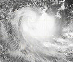
Severe Tropical Cyclone Xavier (RSMC Nadi Designation: 01F, JTWC Designation: 01P) was a strong pre-season cyclone, that formed on October 20 to the north of the Santa Cruz Islands
. During the next day it rapidly developed and was designated as Tropical Depression 01F later that day, before being designated as Tropical Cyclone Xavier while over Santa Cruz early on October 22. Later on October 22, Xavier intensified into a category 3 severe tropical cyclone on the Australian Tropical Cyclone Intensity Scale, before passing over Tikopia
early the next day. Xavier then reached its peak wind speeds of 175 km/h (110 mph 10-min), which made it a Category 4 cyclone early on October 24. Xavier stayed at its peak wind speeds until early the next day when it started to rapidly weaken, becoming a depression early on October 26. The remnants of Xavier persisted until October 28 before dissipating. There were no casualties reported as a result of the storm and little impact reported in the Solomon Islands
and Vanuatu
.
in Nadi, Fiji (RSMC Nadi) and the Joint Typhoon Warning Center
(JTWC) reported that a tropical disturbance had formed to the north of the Santa Cruz Islands
. The disturbance at this time contained a developing low level circulation center
with convective banding over the eastern side of the disturbance. The centre of the disturbance was located within an active South Pacific Convergence Zone
which had a favorable environment for the disturbance to develop with good outflow
and low vertical wind shear
.
During the next day the disturbance gradually developed with it being designated as Tropical Depression 01F by RSMC Nadi at 2100 UTC, with a Tropical Cyclone Formation Alert
issued an hour later by the JTWC as the low level circulation center had become well defined with flaring convection wrapping into the center. At 0000 UTC on October 22, RSMC Nadi declared that Tropical Depression 01F had intensified into Tropical Cyclone Xavier and was a Category 1 tropical cyclone on the Australian tropical cyclone intensity scale while it was located over Santa Cruz. However it was discovered during post-season analysis that Xavier a Category 1 cyclone six hours earlier than operationally reported. Later that morning the JTWC initiated warnings on Xavier designating it as Cyclone 01P.
During October 22, Xavier moved slowly over Santa Cruz and became more organized with an eye
developing before later that day being upgraded to a Category 3 severe tropical cyclone as a clear eye feature had developed in a tightly-wrapped central core. During the next day Xavier passed over Tikopia
as a severe tropical cyclone. After passing through Tikopia it was predicted that Xavier would start moving towards the west or southwest, which would have taken it through the main islands of Vanuatu
. Early on October 24 it was reported by both RSMC Nadi and the JTWC that Cyclone Xavier had reached its peak intensity with wind speeds of 175 km/h (110 mph 10-min) and 215 km/h (130 mph 1-min) respectively, classifying it a Category 4 cyclone on both the Australian tropical cyclone intensity scale and the Saffir Simpson Hurricane Scale.
The cyclone remained at its peak intensity throughout much of October 24, though by 1800 UTC, Xavier had started to show signs of rapid weakening. As a result, Xavier was downgraded to a Category 2 tropical cyclone early the next morning. Xavier then rapidly weakened further to Category 1 tropical cyclone status in response to increasing vertical wind shear. Early on October 26 the cyclone was downgraded to a tropical depression, and had attained characteristics of an extratropical cyclone
. Later that morning both the JTWC and RSMC Nadi issued their final advisories on the depression as the low level circulation center became separated from the area of convection. A high pressure system caused the storm's remnants back to the northwest at a rapid pace, and they fully dissipated on October 28.
in Nadi, Fiji and the Tropical Cyclone Warning Center
in Brisbane
use the Australian Tropical Cyclone Intensity Scale which is based on 10-minute sustained winds and three second gusts for its tropical cyclone tracking information, while the Joint Typhoon Warning Center
uses 1-minute sustained winds. The conversion factor between the two is 1.14. RSMC Nadi's peak intensity for Xavier was 175 km/h (110 mph) 10-minute sustained, or 205 km/h (125 mph) 1-minute sustained. The JTWC's peak intensity for Xavier was 215 km/h (130 mph) 1-minute sustained, or 185 km/h (115 mph) 10-minute sustained.
 Early on October 22, both RSMC Nadi and TCWC Brisbane started to issue special advisories to support the meteorological services of Vanuatu and the Solomon Islands in tracking the cyclone. As Xavier was over the islands of Santa Cruz the whole of Temotu Province
was placed under a tropical cyclone gale warning, while cyclone watches were declared for Rennel, Bellona
, and Vanuatu
. During the next 24 hours, the Torres and Banks Islands, as well as Espirito Santo, Maewo, Ambae, were placed under a cyclone warning. The warnings for the Solomon Islands were then cancelled early the next day, while the warnings for Vanuatu were maintained until late on October 25, when RSMC Nadi discontinued them.
There were no casualties as a result of Xavier. In the Solomon Islands, communications to the Temotu province were lost. When communications were restored on October 24, it was reported that there was only minor tree damage on the islands of Utupua and Vanikolo. On Tikopia, crops sustained damage, though the effects were considered light given the circumstances. As Cyclone Xavier passed the eastern islands of Vanuatu, it produced rough seas with moderate to heavy swells, beach erosion, and strong gusty wind; however, no serious damage was reported.
Santa Cruz Islands
The Santa Cruz Islands are a group of islands in the Pacific Ocean, part of Temotu Province of the Solomon Islands. They lie approximately 250 miles to the southeast of the Solomon Islands Chain...
. During the next day it rapidly developed and was designated as Tropical Depression 01F later that day, before being designated as Tropical Cyclone Xavier while over Santa Cruz early on October 22. Later on October 22, Xavier intensified into a category 3 severe tropical cyclone on the Australian Tropical Cyclone Intensity Scale, before passing over Tikopia
Tikopia
Tikopia is a small and high island in the southwestern Pacific Ocean. Covering an area of 5 km² , the island is the remnant of an extinct volcano. Its highest point, Mt. Reani, reaches an elevation of 380 m above sea level. Lake Te Roto covers an old volcanic crater which is 80 m...
early the next day. Xavier then reached its peak wind speeds of 175 km/h (110 mph 10-min), which made it a Category 4 cyclone early on October 24. Xavier stayed at its peak wind speeds until early the next day when it started to rapidly weaken, becoming a depression early on October 26. The remnants of Xavier persisted until October 28 before dissipating. There were no casualties reported as a result of the storm and little impact reported in the Solomon Islands
Solomon Islands
Solomon Islands is a sovereign state in Oceania, east of Papua New Guinea, consisting of nearly one thousand islands. It covers a land mass of . The capital, Honiara, is located on the island of Guadalcanal...
and Vanuatu
Vanuatu
Vanuatu , officially the Republic of Vanuatu , is an island nation located in the South Pacific Ocean. The archipelago, which is of volcanic origin, is some east of northern Australia, northeast of New Caledonia, west of Fiji, and southeast of the Solomon Islands, near New Guinea.Vanuatu was...
.
Meteorological history
On October 20, 2006, both the Regional Specialized Meteorological CenterRegional Specialized Meteorological Center
A Regional Specialized Meteorological Centre is responsible for the distribution of information, advisories, and warnings regarding the specific program they have a part of, agreed by consensus at the World Meteorological Organization as part of the World Weather Watch.-Tropical...
in Nadi, Fiji (RSMC Nadi) and the Joint Typhoon Warning Center
Joint Typhoon Warning Center
The Joint Typhoon Warning Center is a joint United States Navy – United States Air Force task force located at the Naval Maritime Forecast Center in Pearl Harbor, Hawaii...
(JTWC) reported that a tropical disturbance had formed to the north of the Santa Cruz Islands
Santa Cruz Islands
The Santa Cruz Islands are a group of islands in the Pacific Ocean, part of Temotu Province of the Solomon Islands. They lie approximately 250 miles to the southeast of the Solomon Islands Chain...
. The disturbance at this time contained a developing low level circulation center
Eye (cyclone)
The eye is a region of mostly calm weather found at the center of strong tropical cyclones. The eye of a storm is a roughly circular area and typically 30–65 km in diameter. It is surrounded by the eyewall, a ring of towering thunderstorms where the second most severe weather of a cyclone...
with convective banding over the eastern side of the disturbance. The centre of the disturbance was located within an active South Pacific Convergence Zone
South Pacific convergence zone
The South Pacific Convergence Zone , a reverse-oriented monsoon trough, is a band of low-level convergence, cloudiness and precipitation extending from the west Pacific warm pool south-eastwards towards French Polynesia...
which had a favorable environment for the disturbance to develop with good outflow
Outflow (meteorology)
Outflow, in meteorology, is air that flows outwards from a storm system. It is associated with ridging, or anticyclonic flow. In the low levels of the troposphere, outflow radiates from thunderstorms in the form of a wedge of rain-cooled air, which is visible as a thin rope-like cloud on weather...
and low vertical wind shear
Wind shear
Wind shear, sometimes referred to as windshear or wind gradient, is a difference in wind speed and direction over a relatively short distance in the atmosphere...
.
During the next day the disturbance gradually developed with it being designated as Tropical Depression 01F by RSMC Nadi at 2100 UTC, with a Tropical Cyclone Formation Alert
Tropical Cyclone Formation Alert
A Tropical Cyclone Formation Alert is a bulletin released by the U.S. Navy-operated Joint Typhoon Warning Center in Honolulu, Hawaii or the Naval Maritime Forecast Center in Norfolk, Virginia, warning of the possibility of a tropical cyclone forming from a tropical disturbance that has been...
issued an hour later by the JTWC as the low level circulation center had become well defined with flaring convection wrapping into the center. At 0000 UTC on October 22, RSMC Nadi declared that Tropical Depression 01F had intensified into Tropical Cyclone Xavier and was a Category 1 tropical cyclone on the Australian tropical cyclone intensity scale while it was located over Santa Cruz. However it was discovered during post-season analysis that Xavier a Category 1 cyclone six hours earlier than operationally reported. Later that morning the JTWC initiated warnings on Xavier designating it as Cyclone 01P.
During October 22, Xavier moved slowly over Santa Cruz and became more organized with an eye
Eye (cyclone)
The eye is a region of mostly calm weather found at the center of strong tropical cyclones. The eye of a storm is a roughly circular area and typically 30–65 km in diameter. It is surrounded by the eyewall, a ring of towering thunderstorms where the second most severe weather of a cyclone...
developing before later that day being upgraded to a Category 3 severe tropical cyclone as a clear eye feature had developed in a tightly-wrapped central core. During the next day Xavier passed over Tikopia
Tikopia
Tikopia is a small and high island in the southwestern Pacific Ocean. Covering an area of 5 km² , the island is the remnant of an extinct volcano. Its highest point, Mt. Reani, reaches an elevation of 380 m above sea level. Lake Te Roto covers an old volcanic crater which is 80 m...
as a severe tropical cyclone. After passing through Tikopia it was predicted that Xavier would start moving towards the west or southwest, which would have taken it through the main islands of Vanuatu
Vanuatu
Vanuatu , officially the Republic of Vanuatu , is an island nation located in the South Pacific Ocean. The archipelago, which is of volcanic origin, is some east of northern Australia, northeast of New Caledonia, west of Fiji, and southeast of the Solomon Islands, near New Guinea.Vanuatu was...
. Early on October 24 it was reported by both RSMC Nadi and the JTWC that Cyclone Xavier had reached its peak intensity with wind speeds of 175 km/h (110 mph 10-min) and 215 km/h (130 mph 1-min) respectively, classifying it a Category 4 cyclone on both the Australian tropical cyclone intensity scale and the Saffir Simpson Hurricane Scale.
The cyclone remained at its peak intensity throughout much of October 24, though by 1800 UTC, Xavier had started to show signs of rapid weakening. As a result, Xavier was downgraded to a Category 2 tropical cyclone early the next morning. Xavier then rapidly weakened further to Category 1 tropical cyclone status in response to increasing vertical wind shear. Early on October 26 the cyclone was downgraded to a tropical depression, and had attained characteristics of an extratropical cyclone
Extratropical cyclone
Extratropical cyclones, sometimes called mid-latitude cyclones or wave cyclones, are a group of cyclones defined as synoptic scale low pressure weather systems that occur in the middle latitudes of the Earth having neither tropical nor polar characteristics, and are connected with fronts and...
. Later that morning both the JTWC and RSMC Nadi issued their final advisories on the depression as the low level circulation center became separated from the area of convection. A high pressure system caused the storm's remnants back to the northwest at a rapid pace, and they fully dissipated on October 28.
Differences among warning centers
The Regional Specialized Meteorological CenterRegional Specialized Meteorological Center
A Regional Specialized Meteorological Centre is responsible for the distribution of information, advisories, and warnings regarding the specific program they have a part of, agreed by consensus at the World Meteorological Organization as part of the World Weather Watch.-Tropical...
in Nadi, Fiji and the Tropical Cyclone Warning Center
Regional Specialized Meteorological Center
A Regional Specialized Meteorological Centre is responsible for the distribution of information, advisories, and warnings regarding the specific program they have a part of, agreed by consensus at the World Meteorological Organization as part of the World Weather Watch.-Tropical...
in Brisbane
Brisbane
Brisbane is the capital and most populous city in the Australian state of Queensland and the third most populous city in Australia. Brisbane's metropolitan area has a population of over 2 million, and the South East Queensland urban conurbation, centred around Brisbane, encompasses a population of...
use the Australian Tropical Cyclone Intensity Scale which is based on 10-minute sustained winds and three second gusts for its tropical cyclone tracking information, while the Joint Typhoon Warning Center
Joint Typhoon Warning Center
The Joint Typhoon Warning Center is a joint United States Navy – United States Air Force task force located at the Naval Maritime Forecast Center in Pearl Harbor, Hawaii...
uses 1-minute sustained winds. The conversion factor between the two is 1.14. RSMC Nadi's peak intensity for Xavier was 175 km/h (110 mph) 10-minute sustained, or 205 km/h (125 mph) 1-minute sustained. The JTWC's peak intensity for Xavier was 215 km/h (130 mph) 1-minute sustained, or 185 km/h (115 mph) 10-minute sustained.
Preparations and impact
Temotu Province
Temotu is the easternmost province of the Solomon Islands. The province was formerly known as Santa Cruz Islands Province. It consists, essentially, of two chains of islands which run parallel to each other from the northwest to the southeast.- Islands :...
was placed under a tropical cyclone gale warning, while cyclone watches were declared for Rennel, Bellona
Bellona
-Places:United States of America*Bellona Foundry and adjacent Bellona Arsenal, 19th century United States Army and Confederate munitions factory and depot in VirginiaItaly*Bellona, Campania, a comune in the Province of CasertaSolomon Islands...
, and Vanuatu
Vanuatu
Vanuatu , officially the Republic of Vanuatu , is an island nation located in the South Pacific Ocean. The archipelago, which is of volcanic origin, is some east of northern Australia, northeast of New Caledonia, west of Fiji, and southeast of the Solomon Islands, near New Guinea.Vanuatu was...
. During the next 24 hours, the Torres and Banks Islands, as well as Espirito Santo, Maewo, Ambae, were placed under a cyclone warning. The warnings for the Solomon Islands were then cancelled early the next day, while the warnings for Vanuatu were maintained until late on October 25, when RSMC Nadi discontinued them.
There were no casualties as a result of Xavier. In the Solomon Islands, communications to the Temotu province were lost. When communications were restored on October 24, it was reported that there was only minor tree damage on the islands of Utupua and Vanikolo. On Tikopia, crops sustained damage, though the effects were considered light given the circumstances. As Cyclone Xavier passed the eastern islands of Vanuatu, it produced rough seas with moderate to heavy swells, beach erosion, and strong gusty wind; however, no serious damage was reported.