
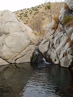
Deep Creek Hot Springs
Encyclopedia
Hot spring
A hot spring is a spring that is produced by the emergence of geothermally heated groundwater from the Earth's crust. There are geothermal hot springs in many locations all over the crust of the earth.-Definitions:...
s located in the northern Mojave Desert
Mojave Desert
The Mojave Desert occupies a significant portion of southeastern California and smaller parts of central California, southern Nevada, southwestern Utah and northwestern Arizona, in the United States...
section of the San Bernardino National Forest
San Bernardino National Forest
San Bernardino National Forest is a federally-managed forest covering more than 800,000 acres . There are two main divisions which are the San Bernardino Mountains on the easternmost of the Transverse Range, and the San Jacinto and Santa Rosa Mountains on the northernmost of the Peninsular...
, near Hesperia
Hesperia, California
Hesperia is a city in San Bernardino County, California, United States. It is located in the Mojave Desert north of San Bernardino. The locals refer to the surrounding area as the High Desert...
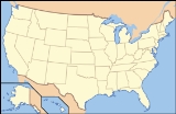
in San Bernardino County
San Bernardino County, California
San Bernardino County is a county in the U.S. state of California. As of the 2010 census, the population was 2,035,210, up from 1,709,434 as of the 2000 census...
, Southern California
California
California is a state located on the West Coast of the United States. It is by far the most populous U.S. state, and the third-largest by land area...
.
Geography
The springSpring (hydrosphere)
A spring—also known as a rising or resurgence—is a component of the hydrosphere. Specifically, it is any natural situation where water flows to the surface of the earth from underground...
s are in the rain shadow
Rain shadow
A rain shadow is a dry area on the lee side of a mountainous area. The mountains block the passage of rain-producing weather systems, casting a "shadow" of dryness behind them. As shown by the diagram to the right, the warm moist air is "pulled" by the prevailing winds over a mountain...
ed desert foothills of the San Bernardino Mountains
San Bernardino Mountains
The San Bernardino Mountains are a short transverse mountain range north and east of San Bernardino in Southern California in the United States. The mountains run for approximately 60 miles east-west on the southern edge of the Mojave Desert in southwestern San Bernardino County, north of the...
on the Deep Creek fork of the Mojave River
Mojave River
The Mojave River is an intermittent river in the eastern San Bernardino Mountains and Mojave Desert in San Bernardino County, California. The river is notable as most of its flow is underground, while its surface channels remain dry most of the time, with the exception of the headwaters and several...
. They are in a large bouldered riparian zone
Riparian zone
A riparian zone or riparian area is the interface between land and a river or stream. Riparian is also the proper nomenclature for one of the fifteen terrestrial biomes of the earth. Plant habitats and communities along the river margins and banks are called riparian vegetation, characterized by...
, surrounded by an rich habitat
Habitat
* Habitat , a place where a species lives and grows*Human habitat, a place where humans live, work or play** Space habitat, a space station intended as a permanent settlement...
ecotone
Ecotone
An ecotone is a transition area between two biomes but different patches of the landscape, such as forest and grassland. It may be narrow or wide, and it may be local or regional...
of the xeric shrublands
Deserts and xeric shrublands
Deserts and xeric shrublands is a biome characterized by, relating to, or requiring only a small amount of moisture.-Definition and occurrence:...
—desert chaparral, montane chaparral and woodlands
California montane chaparral and woodlands
The California montane chaparral and woodlands ecoregion covers , including the mountains of the Transverse, Peninsular, and Santa Lucia Ranges of California. It is part of the Mediterranean forests, woodlands, and scrub biome, with cool, wet winters and hot, dry summers...
, and conifer forest plant communities.
The Southwestern Arroyo Toad—Bufo Californicus
Arroyo toad
The Arroyo toad, Anaxyrus californicus , is a stocky, blunt-nosed, warty-skinned species of toad, between 5 and 7.5 cm long. It has horizontal pupils, and is greenish, grey or salmon on the dorsum with a light-colored stripe across the head and eyelids...
, an endangered species
Endangered species
An endangered species is a population of organisms which is at risk of becoming extinct because it is either few in numbers, or threatened by changing environmental or predation parameters...
, lives along Deep Creek.
Recreation
Deep Creek Hot Springs, being located next to Deep Creek, provides both hot and cold water locations for clothing optional bathing. The site is managed by the San Bernardino National Forest. Water from the creek or pools is not advised for consumption without treatment or filtering, and bringing sufficient drinking waterDrinking water
Drinking water or potable water is water pure enough to be consumed or used with low risk of immediate or long term harm. In most developed countries, the water supplied to households, commerce and industry is all of drinking water standard, even though only a very small proportion is actually...
is advised. The Pacific Crest Trail
Pacific Crest Trail
The Pacific Crest Trail is a long-distance mountain hiking and equestrian trail on the Western Seaboard of the United States. The southern terminus is at the California border with Mexico...
along the creek crosses the area.
Directions
- Interstate 15Interstate 15 in CaliforniaIn the U.S. state of California, Interstate 15 is a major north–south route through the San Bernardino, Riverside, and San Diego Counties, and it has a length of in the state. It is a major thoroughfare for traffic between Southern California and Las Vegas, Nevada, as well as points beyond...
to the Bear Valley exit in VictorvilleVictorville, CaliforniaVictorville is a city located in the Victor Valley of southwestern San Bernardino County, California. According to the U.S. Census Bureau's 2010 census, the city had a population of 115,903, up from 64,030 at the 2000 census.-Geography and climate:...
. - Bear Valley (east) proceeding ten miles (16 km) to Central.
- Right on Central (south) proceeding three miles (past railroad tracks and over a steep hill) to Ocotillo.
- Left (east) on Ocotillo proceeding 2.2 miles (3.5 km) to Bowen Ranch Road (after it becomes dirt surfaced).
- Right (south) on Bowen Ranch Road, proceeding approximately six miles to Bowen Ranch (fee) parking and trailhead.
- The hike, approximately two miles, drops over 900 feet (274.3 m) in altitude. Some parts of the trail are rough, with sturdy hiking bootHiking bootHiking boots are footwear specifically designed for the sport of hiking. They are considered the most important hiking gear since their quality and durability can determine a hiker's ability to move farther, faster, and more safely...
s advised.
- or
- Pacific Crest Trail (free), a six mile hike east from the trailhead at Arrowhead Lake Road.
Regulations
The Deep Creek Hot Springs regulations include:- Closed to the public from sundown to sunrise
- Public nudityPublic nudityPublic nudity or nude in public refers to nudity not in an entirely private context. It refers to a person appearing nude in a public place or to be seen from a public place. It also includes nudity in a semi-public place, where the general public is free to enter, such as a shopping mall...
is not permitted within 1/4 mile of 'T-6 crossing.' - No camping is permitted within 1 miles (1.6 km) of Deep Creek.
- No fire, campfireCampfireA campfire is a fire lit at a campsite, to serve the following functions: light, warmth, a beacon, a bug and/or apex predator deterrent, to cook, and for a psychological sense of security. In established campgrounds they are usually in a fire ring for safety. Campfires are a popular feature of...
s or stoves allowed in the Deep Creek drainage basinDrainage basinA drainage basin is an extent or an area of land where surface water from rain and melting snow or ice converges to a single point, usually the exit of the basin, where the waters join another waterbody, such as a river, lake, reservoir, estuary, wetland, sea, or ocean...
. - No glass containers permitted within 1 miles (1.6 km) of Deep Creek
- Pack out all refuse.
- State designation Wild Trout Stream, the Deep Creek Wild TroutTroutTrout is the name for a number of species of freshwater and saltwater fish belonging to the Salmoninae subfamily of the family Salmonidae. Salmon belong to the same family as trout. Most salmon species spend almost all their lives in salt water...
Area- Limit two fish. Must be eight inches (203 mm) or larger
- Artificial LuresFishing lureA fishing lure is an object attached to the end of a fishing line which is designed to resemble and move like the prey of a fish. The purpose of the lure is to use movement, vibration, and colour to catch the fish's attention so it bites the hook...
or FliesArtificial flyAn artificial fly or fly lure is a type of fishing lure, usually used in the sport of fly fishing . In general, artificial flies are the bait which fly fishers present to their target species of fish while fly fishing...
with barbless hooks only.
External links
- http://www.fs.usda.gov/wps/portal/fsinternet/!ut/p/c4/04_SB8K8xLLM9MSSzPy8xBz9CP0os3gDfxMDT8MwRydLA1cj72BTJw8jAwjQL8h2VAQAzHJMsQ!!/?ss=110512&navtype=BROWSEBYSUBJECT&cid=FSE_003714&navid=110160000000000&pnavid=110000000000000&position=BROWSEBYSUBJECT&recid=34152&actid=50&ttype=recarea&pname=San%20Bernardino%20National%20Forest%20-%20Deep%20Creek%20Hot%20SpringsSan Bernardino National Forest: official Deep Creek Hot Springs website]
- Deep Creek Hot Springs Forum
- Deep Creek Volunteers
- Deep Creek Hot Springs: location photo gallery
- Los Angeles Times: "No swimsuit? No problem at Deep Creek Hot Springs"