
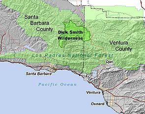
Dick Smith Wilderness
Encyclopedia
California
California is a state located on the West Coast of the United States. It is by far the most populous U.S. state, and the third-largest by land area...
, USA, with a portion in Ventura County
Ventura County, California
Ventura County is a county in the southern part of the U.S. state of California. It is located on California's Pacific coast. It is often referred to as the Gold Coast, and has a reputation of being one of the safest populated places and one of the most affluent places in the country...
. It is completely contained within the Los Padres National Forest
Los Padres National Forest
Los Padres National Forest is a forest located in southern and central California, which includes most of the mountainous land along the California coast from Ventura to Monterey, extending inland...
, and is northeast of the city of Santa Barbara
Santa Barbara, California
Santa Barbara is the county seat of Santa Barbara County, California, United States. Situated on an east-west trending section of coastline, the longest such section on the West Coast of the United States, the city lies between the steeply-rising Santa Ynez Mountains and the Pacific Ocean...
and north of the city of Ojai
Ojai, California
Ojai is a city in Ventura County, California, USA. It is situated in the Ojai Valley , surrounded by hills and mountains. The population was 7,461 at the 2010 census, down from 7,862 at the 2000 census.-History:Chumash Indians were the early inhabitants of the valley...
. It is most easily accessible from two trailheads off State Route 33, which runs north from Ojai. It is adjacent to the large San Rafael Wilderness
San Rafael Wilderness
The San Rafael Wilderness is a wilderness area in the mountains of north central Santa Barbara County, California, USA. It is completely contained within the Los Padres National Forest, and is north of the city of Santa Barbara and east of Santa Maria...
on the west and the Matilija Wilderness on the south. Across Highway 33 to the east, and also in the Los Padres National Forest, is the large Sespe Wilderness.
The wilderness is named after Santa Barbaran Dick Smith, who was a reporter, photographer, historian and pioneer in environmental journalism for the Santa Barbara News-Press
Santa Barbara News-Press
The Santa Barbara News-Press is a broadsheet newspaper based in Santa Barbara, California.-History:The News-Press asserts it is the oldest daily newspaper in Southern California, publishing since 1855...
. Smith spent more times in these remote regions of Santa Barbara County than anyone, covering the area on horseback and accompanied by his dog. In recognition of Dick's personal pursuit to preserve the wild back country the area was named in his honor, and the U.S. Congress created the wilderness in 1984 as part of the California Wilderness Act
California Wilderness Act of 1984
The California Wilderness Act of 1984 is a federal law , passed by the United States Congress on September 28, 1984, that authorized the addition of over within the state of California to the National Wilderness Preservation System....
.
Geography
The wilderness is in the Transverse RangesTransverse Ranges
The Transverse Ranges are a group of mountain ranges of southern California, in the Pacific Coast Ranges physiographic region that runs along the Pacific coast from Alaska to Mexico in North America. The Transverse Ranges begin at the southern end of the California Coast Ranges and lie between...
, east of the junction of the San Rafael Mountains
San Rafael Mountains
The San Rafael Mountains are a mountain range in central Santa Barbara County, California, U.S.. They are part of the Transverse Ranges system of Southern California which in turn are part of the Pacific Coast Ranges system of western North America....
and Sierra Madre Mountains
Sierra Madre Mountains (California)
The Sierra Madre Mountains are a mountain range in northern Santa Barbara County, California, USA. They are a portion of the Inner South Coast Ranges, representing the southernmost part, which are themselves part of the Pacific Coast Ranges of western North America. The Sierra Madre Mountains...
at Big Pine Mountain
Big Pine Mountain
Big Pine Mountain is a mountain located in the San Rafael Mountains of the Transverse Ranges in California. High enough to receive snowfall during the winter,...
. Madulce Peak, at 6,541 feet, is the highest mountain completely within the wilderness, and the lowest point is 3,700 feet where Santa Barbara Creek exits to the north. The wilderness contains the divide between two watersheds: the Cuyama River
Cuyama River
The Cuyama River is a river in southern San Luis Obispo County, northern Santa Barbara County, and northern Ventura County, in the U.S. state of California. It joins the Sisquoc River forming the Santa Maria River...
to the north, and the Santa Ynez River
Santa Ynez River
The Santa Ynez River is one of the largest rivers on the Central Coast of California. It is long, flowing from east to west through the Santa Ynez Valley, reaching the Pacific Ocean at Surf, near Vandenberg Air Force Base and the city of Lompoc....
to the south. The major streams carrying runoff to those two rivers are Santa Barbara Creek and Mono Creek, respectively.
The Big Pine Fault cuts through the wilderness from west to east, trending northeast after exiting the wilderness, in the direction of the nearby San Andreas Fault
San Andreas Fault
The San Andreas Fault is a continental strike-slip fault that runs a length of roughly through California in the United States. The fault's motion is right-lateral strike-slip...
, which is only about 12 miles from the wilderness boundary. The Pine Mountain Fault splits off from the Big Pine; it is visible along the southern slope of nearby Reyes Peak. Most rocks in the wilderness are Eocene
Eocene
The Eocene Epoch, lasting from about 56 to 34 million years ago , is a major division of the geologic timescale and the second epoch of the Paleogene Period in the Cenozoic Era. The Eocene spans the time from the end of the Palaeocene Epoch to the beginning of the Oligocene Epoch. The start of the...
marine sediments
Sedimentary rock
Sedimentary rock are types of rock that are formed by the deposition of material at the Earth's surface and within bodies of water. Sedimentation is the collective name for processes that cause mineral and/or organic particles to settle and accumulate or minerals to precipitate from a solution....
, with some scattered outcrops of Pliocene
Pliocene
The Pliocene Epoch is the period in the geologic timescale that extends from 5.332 million to 2.588 million years before present. It is the second and youngest epoch of the Neogene Period in the Cenozoic Era. The Pliocene follows the Miocene Epoch and is followed by the Pleistocene Epoch...
, Miocene
Miocene
The Miocene is a geological epoch of the Neogene Period and extends from about . The Miocene was named by Sir Charles Lyell. Its name comes from the Greek words and and means "less recent" because it has 18% fewer modern sea invertebrates than the Pliocene. The Miocene follows the Oligocene...
, and Oligocene
Oligocene
The Oligocene is a geologic epoch of the Paleogene Period and extends from about 34 million to 23 million years before the present . As with other older geologic periods, the rock beds that define the period are well identified but the exact dates of the start and end of the period are slightly...
sediments, especially immediately to the south of the Pine Mountain Fault (the contact between these rock units and the Eocene sediments defines the Big Pine Fault).
Climate
The climate of the wilderness is MediterraneanMediterranean climate
A Mediterranean climate is the climate typical of most of the lands in the Mediterranean Basin, and is a particular variety of subtropical climate...
, but modified by distance from the ocean. Since much of the wilderness is separated from the ocean by a mountain divide, and is at fairly high altitude, freezes are common in the winter, as is occasional snow. Summers at lower elevations are hot and dry; rain is extremely rare between April and October, and dry lightning from the occasional thunderstorms can start fires.
Vegetation and wildlife
Vegetation in the wilderness is predominantly chaparral, although there are regions of conifers, including big cone Douglas fir, especially on north-facing slopes, such as the northern exposure of Madulce Peak. Streams contain riparian vegetation, and there are some stands of oak trees. A relictRelict
A relict is a surviving remnant of a natural phenomenon.* In biology a relict is an organism that at an earlier time was abundant in a large area but now occurs at only one or a few small areas....
population of great basin sagebrush (Artemisia tridentata
Artemisia tridentata
Artemisia tridentata is a shrub or small tree from the family Asteraceae. Some botanists treat it in the segregate genus Seriphidium, as S. tridentatum W. A. Weber, but this is not widely followed...
) is visible along Highway 33 at the Bear Canyon trailhead; several populations of this species are left over from the last glacial epoch, when it was more widespread due to the cooler climate then.
Wildlife that may be encountered in the wilderness includes coyote
Coyote
The coyote , also known as the American jackal or the prairie wolf, is a species of canine found throughout North and Central America, ranging from Panama in the south, north through Mexico, the United States and Canada...
s, black bear
American black bear
The American black bear is a medium-sized bear native to North America. It is the continent's smallest and most common bear species. Black bears are omnivores, with their diets varying greatly depending on season and location. They typically live in largely forested areas, but do leave forests in...
s, and mountain lions. The California Condor
California Condor
The California Condor is a New World vulture, the largest North American land bird. Currently, this condor inhabits only the Grand Canyon area, Zion National Park, and coastal mountains of central and southern California and northern Baja California...
can occasionally be seen, since the endangered bird was released back into the wild in 1992, and the wilderness is positioned between the two major Southern California condor sanctuaries, the Sisquoc (in the San Rafael Wilderness to the northwest) and the Sespe (in the Sespe wilderness to the southeast).
History
The region has been continuously inhabited by humans for over 10,000 years. Rock art by the resident Chumash Indians is scattered across the region; locations of rock paintings are generally not made public for fear of vandalism.Almost all of the wilderness was burned in 2007 by the Zaca Fire
Zaca Fire
The Zaca Fire was a wildfire which began burning northeast of Buellton, California, in Santa Barbara County, California. The fire started on July 4, 2007 and by August 31, it had burned over , making it California's second largest fire in recorded history after the Cedar Fire of 2003. The fire was...
.