Dolgiy Island
Encyclopedia


Pechora Sea
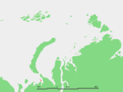
Pechora Sea , is a sea at the northwest of Russia, the southeastern part of the Barents Sea. The western border of the sea is off Kolguyev Island, while the eastern border is the western coasts of Vaygach Island and the Yugorsky Peninsula, and the northern border the southern end of Novaya...
, east of the Khaypudyr Bay
Khaypudyr Bay
Khaypudyr Bay or Khaypudyrskaya Bay is a gulf in Russia, located in the Pechora Sea between the coastline of the Yugorsky Peninsula and the lowlands and marshy areas in the mainland south of Dolgiy Island. Its latitude is 68° 30' N and the longitude 59° 30' E.The Khaypudyr Bay has a smaller bay...
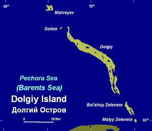
. Long and narrow, this island is 38 kilometres (23.6 mi) in length, with an average width of 2.8 kilometres (1.7 mi). It stretches roughly from north-west to south-east and there are smaller islands at both of its ends, Matveyev Island in the north and Bolshoy Zelenets and Maly Zelenets in the south, which are a prolongation of the same submarine structure.
Dolgy Island's southern tip is only 12 kilometres (7.5 mi) from the mainland. This island is administratively a part of Nenets Autonomous Okrug
Nenets Autonomous Okrug
Nenets Autonomous Okrug is a federal subject of Russia .It has an area of 176,700 km2 and population of 42,628 as of the preliminary results of the 2010 Census , 21,296 of whom live in Naryan-Mar, the administrative center.-Geography and ecology:The arctic ecology of this...
, an autonomous okrug
Okrug
Okrug is an administrative division of some Slavic states. The word "okrug" is a loanword in English, but it is nevertheless often translated as "area", "district", or "region"....
of Arkhangelsk Oblast
Arkhangelsk Oblast
Arkhangelsk Oblast is a federal subject of Russia . It includes the Arctic archipelagos of Franz Josef Land and Novaya Zemlya, as well as the Solovetsky Islands in the White Sea....
.
This island should not be confused with other islands called "Dolgy", one of which is located in the Barents Sea itself in the bay southeast of Khodovarikha
Khodovarikha
Khodovarikha is a point in the coast of the Pechora Sea located on a landspit projecting eastwards over the bay. Latitude: 68° 57' Longitude: 53° 45'...
and the other in Karelia
Karelia
Karelia , the land of the Karelian peoples, is an area in Northern Europe of historical significance for Finland, Russia, and Sweden...
. Dikson Island was also formerly called "Dolgy".
History
Stepan MalyginStepan Malygin
Stepan Gavrilovich Malygin was a Russian Arctic explorer.In 1711–1717, Stepan Malygin was a student at the Moscow School of Mathematical and Navigational Sciences. After his graduation, Malygin began his career as a naval cadet and was then promoted to the rank of lieutenant four years later...
undertook a voyage starting from Dolgy Island in 1736-1737. There were two ships in this early expedition, the Pervy, under Malygin and the Vtoroy under the command of captain A. Skuratov. After entering the little-explored Kara Sea
Kara Sea
The Kara Sea is part of the Arctic Ocean north of Siberia. It is separated from the Barents Sea to the west by the Kara Strait and Novaya Zemlya, and the Laptev Sea to the east by the Severnaya Zemlya....
, they sailed to the mouth of the Ob River
Gulf of Ob
The Gulf of Ob is a gigantic bay of the Arctic Ocean, located in Northern Russia at the head the mouth of the Ob River....
.
Malygin took careful observations of these hitherto almost unknown areas of the Russian Arctic coastline. With this knowledge he was able to draw the first somewhat accurate map of the Arctic shores between the Pechora River
Pechora River
The Pechora River is a river in northwest Russia which flows north into the Arctic Ocean on the west side of the Ural Mountains. It lies mostly in the Komi Republic but the northernmost part crosses the Nenets Autonomous Okrug. It is 1,809 km long and its basin is 322,000 square kilometers...
and the Ob River
Ob River
The Ob River , also Obi, is a major river in western Siberia, Russia and is the world's seventh longest river. It is the westernmost of the three great Siberian rivers that flow into the Arctic Ocean .The Gulf of Ob is the world's longest estuary.-Names:The Ob is known to the Khanty people as the...
.

