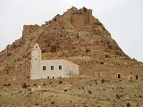
Douiret
Encyclopedia
Douiret is a ruined Berber
village in the Tataouine
district in southern Tunisia
. Located on a hilltop near a modern village of the same name, Douiret was a fortified granary
, or ksar
(plural ksour.) Like other ksour created by North African Berber communities, Douiret was built on a hilltop to help protect it from raiding parties. Douiret is a regular stop on southern Tunisia's ksar
trail, along with the villages of Chenini
, Ksar Ouled Soltane
and Ksar Hadada
.
The old village of Douiret is located 22 Km southwest of Tataouine in a rugged mountainous region. The old village transformed into ruins is surmounted by its citadel or ksar overlooking troglodyte houses dug in the mountain and aligned in a meandering fashion along its cliff. A path of about 3 Km is lined up with abandoned dwellings mostly in ruins with the exception of the eye-catching white mosque (known as 'the palm tree mosque' or Jamaa ennakhla) at midway and a couple of renovated dwellings serving as a showcase and/or an atypical motel to host visitors and tourists.
In the 20th century, Douiret had seen its population progressively decrease as many of its inhabitants migrated mainly to the Tunisian capitol Tunis. By the close of the 20th century and the beginning of the 21st century, the old village of Douiret has virtually transformed into a gost town in ruins as the few remaining families opted to move to the new village of Douiret built at the mountain foothills not far from their ancestors' historic site.
Source: Douiret.net
Berber people
Berbers are the indigenous peoples of North Africa west of the Nile Valley. They are continuously distributed from the Atlantic to the Siwa oasis, in Egypt, and from the Mediterranean to the Niger River. Historically they spoke the Berber language or varieties of it, which together form a branch...
village in the Tataouine
Tataouine
Tataouine , also transliterated as Tatooine, Tatahouine, Tatahouïne, Tatawin, Fum Taţāwīn, Fumm Tattauin, Foum Tatahouine, Fum Tatawin, or Foum Tataouine, from the Berber Tittawin, literally meaning Eyes, with the figurative meaning of Water springs , is a city located in southern Tunisia...
district in southern Tunisia
Tunisia
Tunisia , officially the Tunisian RepublicThe long name of Tunisia in other languages used in the country is: , is the northernmost country in Africa. It is a Maghreb country and is bordered by Algeria to the west, Libya to the southeast, and the Mediterranean Sea to the north and east. Its area...
. Located on a hilltop near a modern village of the same name, Douiret was a fortified granary
Granary
A granary is a storehouse for threshed grain or animal feed. In ancient or primitive granaries, pottery is the most common use of storage in these buildings. Granaries are often built above the ground to keep the stored food away from mice and other animals.-Early origins:From ancient times grain...
, or ksar
Ksar
Ksar is the Arabic term for "castle", loaned from Latin castrum.The Berber equivalent is aghrem or ighrman ....
(plural ksour.) Like other ksour created by North African Berber communities, Douiret was built on a hilltop to help protect it from raiding parties. Douiret is a regular stop on southern Tunisia's ksar
Ksar
Ksar is the Arabic term for "castle", loaned from Latin castrum.The Berber equivalent is aghrem or ighrman ....
trail, along with the villages of Chenini
Chenini
Chenini is a ruined Berber village in the Tataouine district in southern Tunisia. Located on a hilltop near a modern village of the same name, Chenini was a fortified granary, or ksar Like other ksour created by North African Berber communities, Chenini was built on a hilltop - in this instance,...
, Ksar Ouled Soltane
Ksar Ouled Soltane
Ksar Ouled Soltane is a fortified granary, or ksar, located in the Tataouine district in southern Tunisia. The ksar is spread out over two courtyards, each of which has a perimeter of multi-story vaulted granary cellars, or ghorfas...
and Ksar Hadada
Ksar Hadada
Ksar Hadada is a ksar in southeastern Tunisia. Star Wars: The Phantom Menace was filmed here.- External links :*...
.
The old village of Douiret is located 22 Km southwest of Tataouine in a rugged mountainous region. The old village transformed into ruins is surmounted by its citadel or ksar overlooking troglodyte houses dug in the mountain and aligned in a meandering fashion along its cliff. A path of about 3 Km is lined up with abandoned dwellings mostly in ruins with the exception of the eye-catching white mosque (known as 'the palm tree mosque' or Jamaa ennakhla) at midway and a couple of renovated dwellings serving as a showcase and/or an atypical motel to host visitors and tourists.
History
The ancestry of Douiret is believed to be traced back to a founding father with the name of Ghazi Ben Douaieb Bou Kenana, who migrated to the region more than 600 years ago – possibly coming from the Moroccan region of Tafilalet (Louis, A. 1975. Douiret: Étrange Cité Berbère. Societé Tunisienne de Diffusion, Tunis). In 1850, Douiret population was around 3500 inhabitants. It has been an important caravan stop between Gabès to the north and the Libyan city of Ghdamès to the south. In 1882, Douiret was chosen temporarily by colonial France as the center for its military administrative authority in the southern part of Tunisia before abandoning it in favor of Tataouine soon after that.In the 20th century, Douiret had seen its population progressively decrease as many of its inhabitants migrated mainly to the Tunisian capitol Tunis. By the close of the 20th century and the beginning of the 21st century, the old village of Douiret has virtually transformed into a gost town in ruins as the few remaining families opted to move to the new village of Douiret built at the mountain foothills not far from their ancestors' historic site.
Source: Douiret.net

