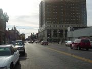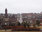
Downtown Duluth
Encyclopedia

Duluth, Minnesota
Duluth is a port city in the U.S. state of Minnesota and is the county seat of Saint Louis County. The fourth largest city in Minnesota, Duluth had a total population of 86,265 in the 2010 census. Duluth is also the second largest city that is located on Lake Superior after Thunder Bay, Ontario,...
, Minnesota
Minnesota
Minnesota is a U.S. state located in the Midwestern United States. The twelfth largest state of the U.S., it is the twenty-first most populous, with 5.3 million residents. Minnesota was carved out of the eastern half of the Minnesota Territory and admitted to the Union as the thirty-second state...
, United States
United States
The United States of America is a federal constitutional republic comprising fifty states and a federal district...
; is situated between Mesaba Avenue (Highway 194
Minnesota State Highway 194
Minnesota State Highway 194 is a highway in northeast Minnesota, which runs from its intersection with U.S. Highway 2 in Solway Township and continues east to its eastern terminus at its Mesaba Avenue interchange with Interstate Highway 35 in downtown Duluth. For part of its route, it runs...
) and 4th Avenue East; and located on Michigan, Superior, First, Second, and Third Streets.
The downtown area is easily accessible from Interstate Highway 35
Interstate 35 in Minnesota
In the U.S. state of Minnesota, Interstate 35 is a highway in southeast, east-central, and northeast Minnesota. The route runs north–south from the Iowa state line through the twin cities of Minneapolis and Saint Paul; where it splits into Interstates 35E and 35W; and ends in the city of...
.
As in most cities, the downtown area is home to a number of the city's cultural and social attractions, as well as government offices and business centers. Duluth's main library is located in downtown, as is the city's foremost museum, the courthouse, city hall, several local restaurants and bars with live music venues, and many of the larger business offices. Stores and places to eat and drink tend to be locally or regionally owned and operated, with most chain and franchise establishments having located (or re-located) themselves in the "Miller Hill area" around the U.S. Highway 53 corridor
Miller Trunk Corridor
The Highway 53 or Miller Trunk Corridor refers to a large agglomeration of retail development in Duluth, Minnesota on and around U.S. Highway 53, and by extension, State Highway 194 , and parts of the Arrowhead, Haines, and Maple Grove Roads...
.
Most of the downtown is within walking distance of the touristy Canal Park
Canal Park (Duluth)
Canal Park is a tourist and recreation-oriented district of Duluth, Minnesota, United States. Situated across the Interstate 35 freeway from Downtown Duluth, it is connected by the famous Aerial Lift Bridge to the Park Point sandbar and neighborhood...
district.
A large portion of the eastern section of downtown is oriented around Essentia Health–St. Mary's Medical Center and Miller-Dwan Medical Center.
Buildings
The downtown area contains a number of historical buildings, many of them dating to the city's peak days in the late 19th century and early 20th. These include the Romanesque RevivalRomanesque Revival architecture
Romanesque Revival is a style of building employed beginning in the mid 19th century inspired by the 11th and 12th century Romanesque architecture...
(Old) Central High School
Central High School (Duluth, Minnesota)
Central High School was a secondary school located in Duluth, Minnesota which educated students in grades nine through twelve. The school first opened in 1893. The mascot of the school was the Trojan...
building (now the administrative offices of Duluth's school district
School district
School districts are a form of special-purpose district which serves to operate the local public primary and secondary schools.-United States:...
), the Duluth Opera House, and the Union Depot (now a museum), among many others. Newly constructed ones are less common than older edifices, although some large newer buildings such as the Tech Village are present.
Streets

Neighborhoods of Duluth, Minnesota
The city of Duluth, overlooking Lake Superior in the U.S. state of Minnesota has several distinct neighborhoods.- Central :*Canal Park*Central Hillside*Downtown Duluth*East Hillside*Park Point- Eastern Duluth :*Chester Park / UMD*Congdon Park...
due to 800 feet (240 m) elevation difference between the shore and the hilltop.
As a part of a beautification project during Duluth's economic crisis of the 1980s, several blacktop streets were converted to brick. Along with this change came the introduction of "old-fashioned" ornamental
Ornament
An ornament is something used for decoration.Ornament may also refer to:*Christmas ornaments, an ornament hung from a Christmas tree*Ornament , purely decorative elements in architecture and the decorative arts*Ornament *Ornamental plant...
streetlamps.
Skywalk
Due to the city's cold winter temperatures (at times falling well below -20°F / -29°C), a network of skywalks was constructed to provide indoor connectivity between most major buildings. The skywalkSkyway
In an urban setting, a skyway, catwalk, sky bridge, or skywalk is a type of pedway consisting of an enclosed or covered bridge between two buildings. This protects pedestrians from the weather. These skyways are usually owned by businesses, and are therefore not public spaces...
system is augmented by an over-the-freeway enclosed walkway leading to the Duluth Entertainment Convention Center
Duluth Entertainment Convention Center
Duluth Entertainment Convention Center , is a multi-purpose arena and convention center complex located in Duluth, Minnesota. It has been home to the University of Minnesota Duluth Bulldog hockey team since 1966...
(DECC) in the Canal Park
Canal Park (Duluth)
Canal Park is a tourist and recreation-oriented district of Duluth, Minnesota, United States. Situated across the Interstate 35 freeway from Downtown Duluth, it is connected by the famous Aerial Lift Bridge to the Park Point sandbar and neighborhood...
district.
See also
- Interstate Highway 35Interstate 35 in MinnesotaIn the U.S. state of Minnesota, Interstate 35 is a highway in southeast, east-central, and northeast Minnesota. The route runs north–south from the Iowa state line through the twin cities of Minneapolis and Saint Paul; where it splits into Interstates 35E and 35W; and ends in the city of...
- Duluth, MinnesotaDuluth, MinnesotaDuluth is a port city in the U.S. state of Minnesota and is the county seat of Saint Louis County. The fourth largest city in Minnesota, Duluth had a total population of 86,265 in the 2010 census. Duluth is also the second largest city that is located on Lake Superior after Thunder Bay, Ontario,...
- Canal ParkCanal Park (Duluth)Canal Park is a tourist and recreation-oriented district of Duluth, Minnesota, United States. Situated across the Interstate 35 freeway from Downtown Duluth, it is connected by the famous Aerial Lift Bridge to the Park Point sandbar and neighborhood...
(south; also considered part of the Central Business District–CBDCentral business districtA central business district is the commercial and often geographic heart of a city. In North America this part of a city is commonly referred to as "downtown" or "city center"...
) - Central HillsideCentral Hillside (Duluth)Central Hillside is a neighborhood in Duluth, Minnesota, United States; located directly uphill from the city's downtown. The neighborhood offers an excellent view of the city and lake....
(north and west) - East HillsideEast Hillside (Duluth)East Hillside is a neighborhood in Duluth, Minnesota, United States.East 4th Street serves as one of the main thoroughfares in the community, as well as a small business corridor...
(east) - Lincoln ParkLincoln Park (Duluth)Lincoln Park is one of the larger neighborhoods in the city of Duluth, Minnesota, United States.Lincoln Park is situated between Garfield Avenue to the ore docks at Carlton Street / 34th Avenue West. The neighborhood stretches up the hill to Skyline Parkway...
(west)

