Drumlin field
Encyclopedia

Drumlin
A drumlin, from the Irish word droimnín , first recorded in 1833, is an elongated whale-shaped hill formed by glacial ice acting on underlying unconsolidated till or ground moraine.-Drumlin formation:...
s, also called a drumlin swarm. Drumlins are one type of landform
Landform
A landform or physical feature in the earth sciences and geology sub-fields, comprises a geomorphological unit, and is largely defined by its surface form and location in the landscape, as part of the terrain, and as such, is typically an element of topography...
that indicate continental ice sheet
Ice age
An ice age or, more precisely, glacial age, is a generic geological period of long-term reduction in the temperature of the Earth's surface and atmosphere, resulting in the presence or expansion of continental ice sheets, polar ice sheets and alpine glaciers...
glaciation. The total depth of glacial deposits may be hundreds of feet deep.
Lake Ontario Example
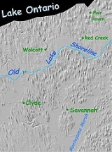
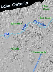
The shaded relief map depicts a large drumlin field that exists in New YorkNew York
New York is a state in the Northeastern region of the United States. It is the nation's third most populous state. New York is bordered by New Jersey and Pennsylvania to the south, and by Connecticut, Massachusetts and Vermont to the east...
between the south shore of Lake Ontario
Lake Ontario
Lake Ontario is one of the five Great Lakes of North America. It is bounded on the north and southwest by the Canadian province of Ontario, and on the south by the American state of New York. Ontario, Canada's most populous province, was named for the lake. In the Wyandot language, ontarío means...
and Cayuga Lake
Cayuga Lake
Cayuga Lake is the longest of central New York's glacial Finger Lakes, and is the second largest in surface area and second largest in volume. It is just under 40 miles long. Its average width is 1.7 miles , and it is at its widest point near Aurora...
, which is just south of Montezuma Marsh
Montezuma Marsh
Montezuma Marsh is a marsh at the northern end of Cayuga Lake in the Finger Lakes region of New York. Much of the marsh is part of the Montezuma National Wildlife Refuge, which is a major point on the route of many migratory birds, such as Canada geese and mallard ducks.The Cayuga valley is an old...
. The old Cayuga valley north of Montezuma Marsh is almost entirely buried under the drumlin field. Possibly the bay at Fair Haven
Fair Haven, New York
Fair Haven is a village in Cayuga County, New York, United States. The population was 884 at the 2000 census.The Village of Fair Haven is within the Town of Sterling and is northwest of Syracuse, New York...
is a remnant of the old valley.
This drumlin field is unique, in that it was greatly modified after it formed. Apparently, as the glacier retreated, it blocked the Lake Ontario outlet through the present St. Lawrence River for a long period, holding the lake at a higher level. A clearly marked shoreline resulted as shown by the light blue line. Drumlins north of that line were islands in the old, larger lake. Near the shore, wave action eroded and entirely removed the drumlins. Farther north, where the water was deeper, the waves eroded the top from each drumlin leaving them with an unusual flat top, instead of the normal elongated dome shape.
There is evidence that the glacier did not advance in a straight line, but rather in the fashion of a tongue or lobe of ice. In the lower right of this image, the orientation of the drumlins show that the ice was moving east of south. As one looks at drumlins farther west, in the Rochester, New York area, it is seen that the drumlins show a turn to the west of south, and as one approaches the Niagara River
Niagara River
The Niagara River flows north from Lake Erie to Lake Ontario. It forms part of the border between the Province of Ontario in Canada and New York State in the United States. There are differing theories as to the origin of the name of the river...
, the drumlins align almost westward.

